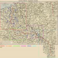
This is the second version of my airfield mapping for Wings: Over Flanders Fields. Credit goes to Rabu for his Flanders map that he has allowed me to use to map airfields on. The Paris map was created entirely by myself. The others were public domain and the airfield data came from WOFF itself. Please do not repost or change and distribute without crediting rabu and myself.
Here is a quick sheet I compiled showing all the default keyboard and joystick controls in Wings: Over Flanders Fields
Here are the Flanders amps with the aerodrome names right on the map. The sidebar is irrelevant material right now.
Here is a map for the Verdun/Meuse-Argonne region with aerodromes marked
Here is the aerodrome map for the Aisne/Marne region.
Here are Rabu's maps of the Somme area with the aerodromes mapped on them.
Here is a map of the Verdun area from late 1916 with all the aerodromes added.
Here is rabu's maps with all the aerodorme locations mapped out as they were in early 1916. there is also a legend on each map with the name of each aerodrome. I just have a generic 3 way tricolor as the emblem for the allies as we have not fully distinguished which aerodromes were used by which country of the Entente. Please be aware that things are not exact... in some places the locations of certain things in game varies when compared to the map. The location of the city of Ypres is one that comes to mind.
Skin for C923 Bristol F2b nightfighter
Skin for the bristol F2.b Fighter. This is a historically accurate skin of Serial number C4879 which was photographed at No.33 TDS Witney apparently after the armistice.
Here is a skin of A7194, which was stationed in Egypt.


