Olham
-
Posts
14,636 -
Joined
-
Last visited
-
Days Won
3
Content Type
Profiles
Forums
Gallery
Downloads
Store
Everything posted by Olham
-

Map 14: Aircraft [von Richtofen's 80 Victories}
Olham replied to Hauksbee's topic in WOFF UE/PE - General Discussion
The beginning of a sentence is always with a capital letter, like in English. "Von" would be correct there. -
Baxter, Australia added All maps are in post 1 of this thread
-
You'll find a psalm for EVERY occasion when you search the bible long enough - even for killing each other. You see, I'm not a religious man, but it is touching to see the devotion of the stone carver.
-
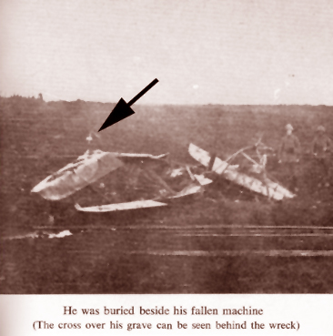
Yes, sure, he was badly wounded. I had that several times in RoF. But you could still try to land the craft, BEFORE you faint.
-
Fighting in the Albatros D.V or D.Va in RoF is not easy online, vs human flyers. The Alb is outdated and even undermodelled - the top speed is at least 10 km/h too slow, and it breaks to easily. Your only chance against a good Camel jockey is: hit him first - and hard. When you are shot up like this feller, you should find a landing area and then shut of the engine. The oil spraying will stop and give you better vision. He could have managed to land the craft, but he spoiled it IMHO.
-
That must have been the right adventure for a kid! Wow, what a location to sneak in to. I hope these Yuppies will not change any of the wall inscriptions and art works done by soldiers. Cause then it could perhaps one day be changed back into a memorial site.
-
Touching, and a bit spooky. Saw it on German TV too. There were some real good art works down there, which still existed.
-
Glubber, California added All maps are in post 1 of this thread
-
Tinmann, Australia added All maps are in post 1 of this thread
-
Russkly, Spain added All maps are in post 1 of this thread
-
JJJ65, Czech Republic added Smosh - New Zealand added CaNy_Ace88, New York, resettled All maps are in post 1 of this thread
-
Great diagram you found there, Hauksbee - that illustrates it all nicely.
-
Only recently I heard or read a funny side-story about the Emden. The natives on some Polynesian island(s) have the name "Emden" implemented into their language. It stand for an action or operation that went perfectly well. They would then say: "That went emden!" (in their own language of course). The reason for that: they saw the "Emden" leaving the anchor place, to engage a (British ?) ship. She returned not long after that, having sunk the enemy vessel. "Emden" by the way is the name of one of the biggest German harbour towns by the North Sea.
-
Holy Schnicky (as Lou would say) - in Germany it wouldn't be allowed! Our insurance companies are kind of almighty.
-
The Goetzen and "The African Queen"
Olham replied to Hauksbee's topic in WOFF UE/PE - General Discussion
Don't think so - it looks too equally IMHO. In German WIKI it doesn't read "...sealed the engine with grease", but "...sealed the most important parts/spots with grease." It looks so regularly equal, that I'd say it is human-made. Might as well be they had added new primer around rivets, and what we see is the state before painting the whole ship again? -
Haha, yeah, that must be true, Hauksbee! Geeze, the next thing would be a motorbike with the tracks of a Sherman! Or with the jet engines of an F-16 fighter...
-
Craaa-zeee!!! I had always thought nothing is bigger than a Münch Mammut (which had a car engine). But in America everything is possible.
-
The Goetzen and "The African Queen"
Olham replied to Hauksbee's topic in WOFF UE/PE - General Discussion
Well, you wrote that the Goetzen was greased and then deliberately sunken. Maybe they had to grease more than just the engines? Another explanation would be small sweetwater mussles, which settled at the edges around rivets. It is too regularly to be bullet holes or anything IMHO. -
The Goetzen and "The African Queen"
Olham replied to Hauksbee's topic in WOFF UE/PE - General Discussion
They are placed in horizontal and vertical order - maybe they were fat-sealed rivets? The photo could have been made before the scuttling? -
"Luisenhof Ferme" - Crash site of Major Lanoe Hawer
Olham replied to Olham's topic in WOFF UE/PE - General Discussion
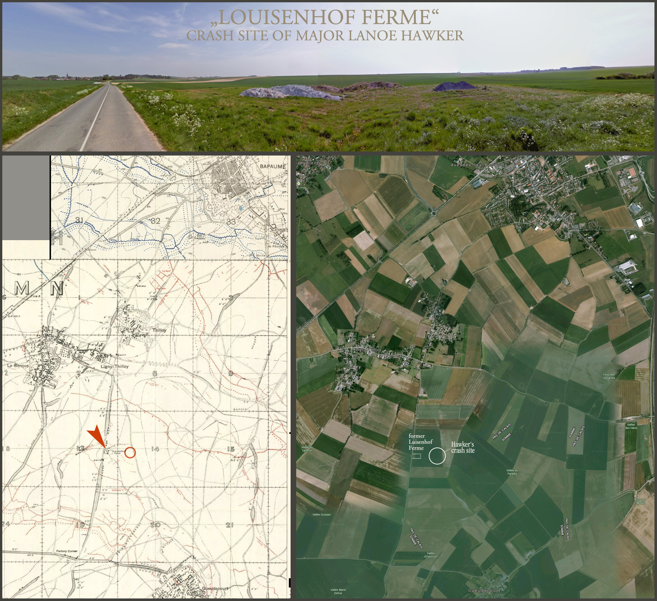
The house is the farm (ferme) - it must have been there in the war already. The crash site was 250 meters east of the farm. -
Thank you, Dezh, for posting the new additions to the McMaster war map archives! With these maps I was now able to find the grounds of former "Luisenhof Ferme", the crash site of Major Lanoe Hawker. From Peter Kilduff: THE RED BARON - BEYOND THE LEGEND "The two aeroplanes went lower and lower as Richthofen fought 'the most difficult battle ... that I experienced thus far...' Then one of Richthofen's guns cleared and he fired right into the back of his opponent. The DH.2 dropped into the mud about 250 m east of Luisenhof Ferme, a devastated farm along the road to Flers, just south of Bapaume. A nearby German Grenadier unit pulled Hawker's body from the wreckage and determined he had been killed by one shot in the back of the head. Hawker was buried on the spot, with the broken DH.2 serving as a final monument." On 23 November 1916 the farm was already devastated, and it seems it was never rebuilt, but torn down. Still though, roads and field paths are recognisable, when you compare the field map with Google Earth.

-
Some people are really ingenious engineers - this feller from Wupperthal has built himself a motorbike with a radial engine! Not sure how practical it is, but it looks cool! http://www.1000ps.at/modellnews-2357113-der-rote-baron

-
The Goetzen and "The African Queen"
Olham replied to Hauksbee's topic in WOFF UE/PE - General Discussion
Touching to see that this ship is still in service - and that she seems to play such an important role down there. Like the railways the British built in India - they are still in use; often with the same old trains and wagons. http://en.wikipedia.org/wiki/MV_Liemba -
Map 30: Germany crushes the Russians...
Olham replied to Hauksbee's topic in WOFF UE/PE - General Discussion
So it was the G.A.P. then (general army proceedure - everyone's very busy; no one knows what he does) - Mmuahahahahaaa!!! -
Map 30: Germany crushes the Russians...
Olham replied to Hauksbee's topic in WOFF UE/PE - General Discussion
And I read under his post: Edited by Hauksbee - how could you edit another member's post???