pagsab
-
Posts
54 -
Joined
-
Last visited
-
Days Won
1
1 Follower
About pagsab

pagsab's Achievements
")


-
Thanks Major Lee! As usual, my recent progress with my computer air gaming inspired me to flip back and model related engagements in my manual air designs, as shown in https://boardgamegeek.com/thread/3715370/tip-and-run. As discussed in my video, it is great to have these two complementary ways of simulating classic air combat missions from different perspectives.
- 11 replies
-
- 1
-

-
- manual terrain
- nw europe
- (and 2 more)
-
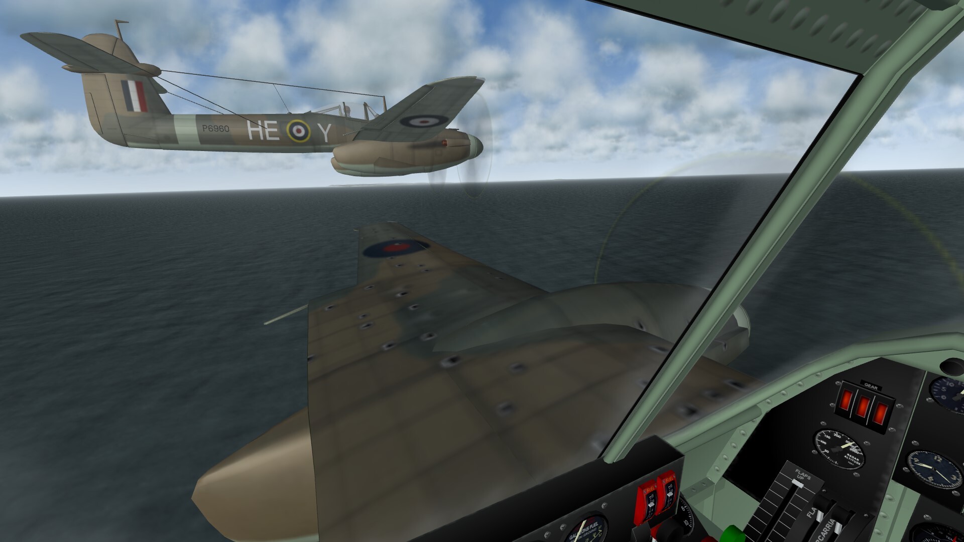
I am currently reading Chris Goss’s 2003 book on ‘Luftwaffe Fighter Bombers over Britain’, which is chock-full of mission reports which leave me itching to model the sorties on my new terrain. I found that by cutting waypoint altitudes manually in the mission file while in the process of cloning my own entry to create my wingman flights, I can get around the minimum heights in the SF2 mission editor and drop my colleagues to 500 feet, giving a much better sense of the wavetop and treetop altitudes common in fighter-bomber sorties. Strafing is fairly easy if targets can be identified in time, but pinpoint bombing is realistically hard without getting dangerously close to one’s own bomb bursts. The picture below shows our Whirlwinds as we at last outdistanced the coastal flak off Calais. For once I had managed to hit and sink our small target vessel, but at the cost of bomb fragments shredding my craft. With no height whatsoever in hand, the White Cliffs looked frighteningly far away...

- 11 replies
-
- 3
-
-
- manual terrain
- nw europe
- (and 2 more)
-
I did too until a year ago, when I discovered how to achieve similar satisfaction from SF2. See my 3D air gaming video at https://www.youtube.com/@philipsabin1653 for a quick review of my own experiences.
- 11 replies
-
- 2
-
-
- manual terrain
- nw europe
- (and 2 more)
-
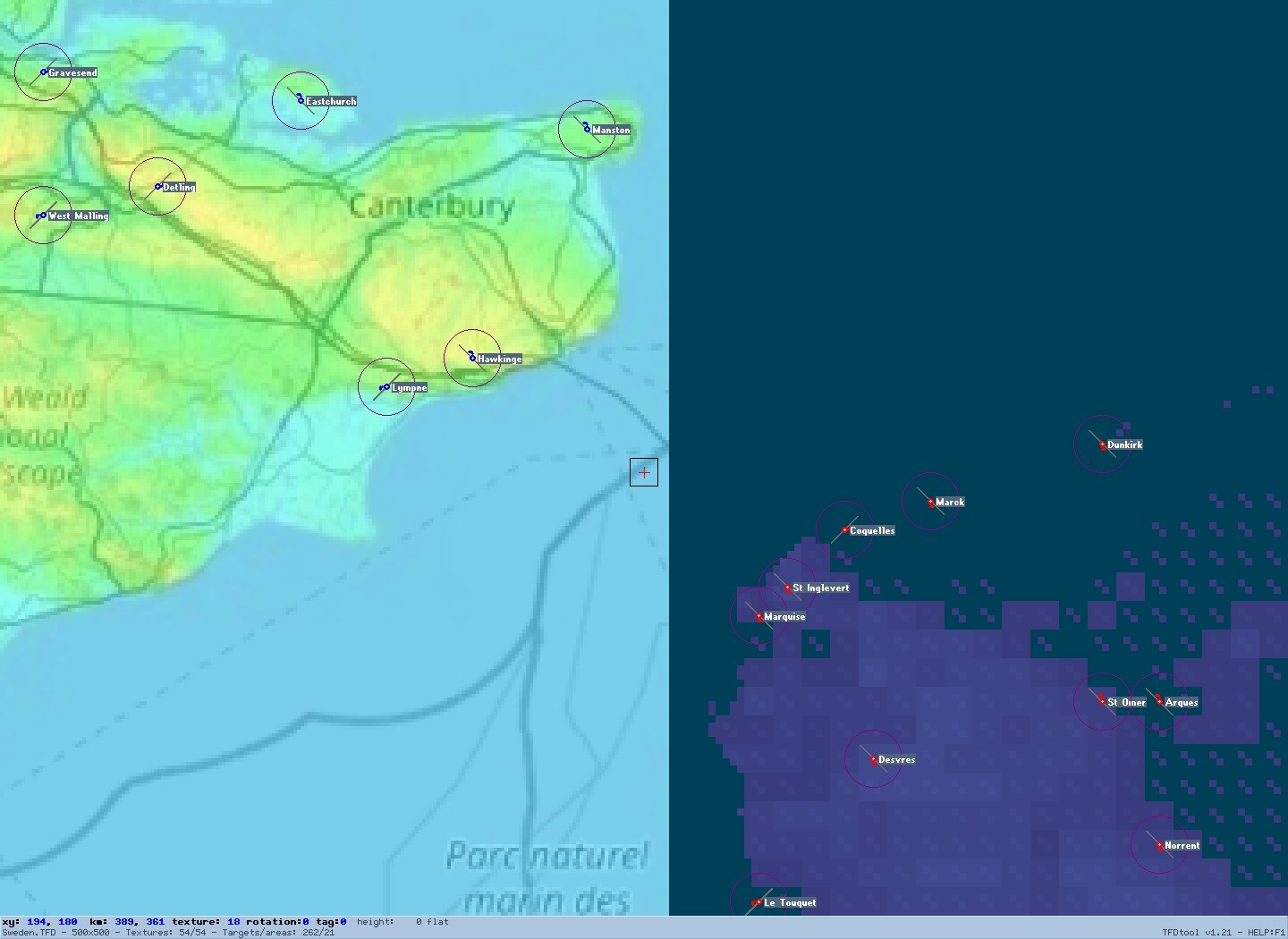
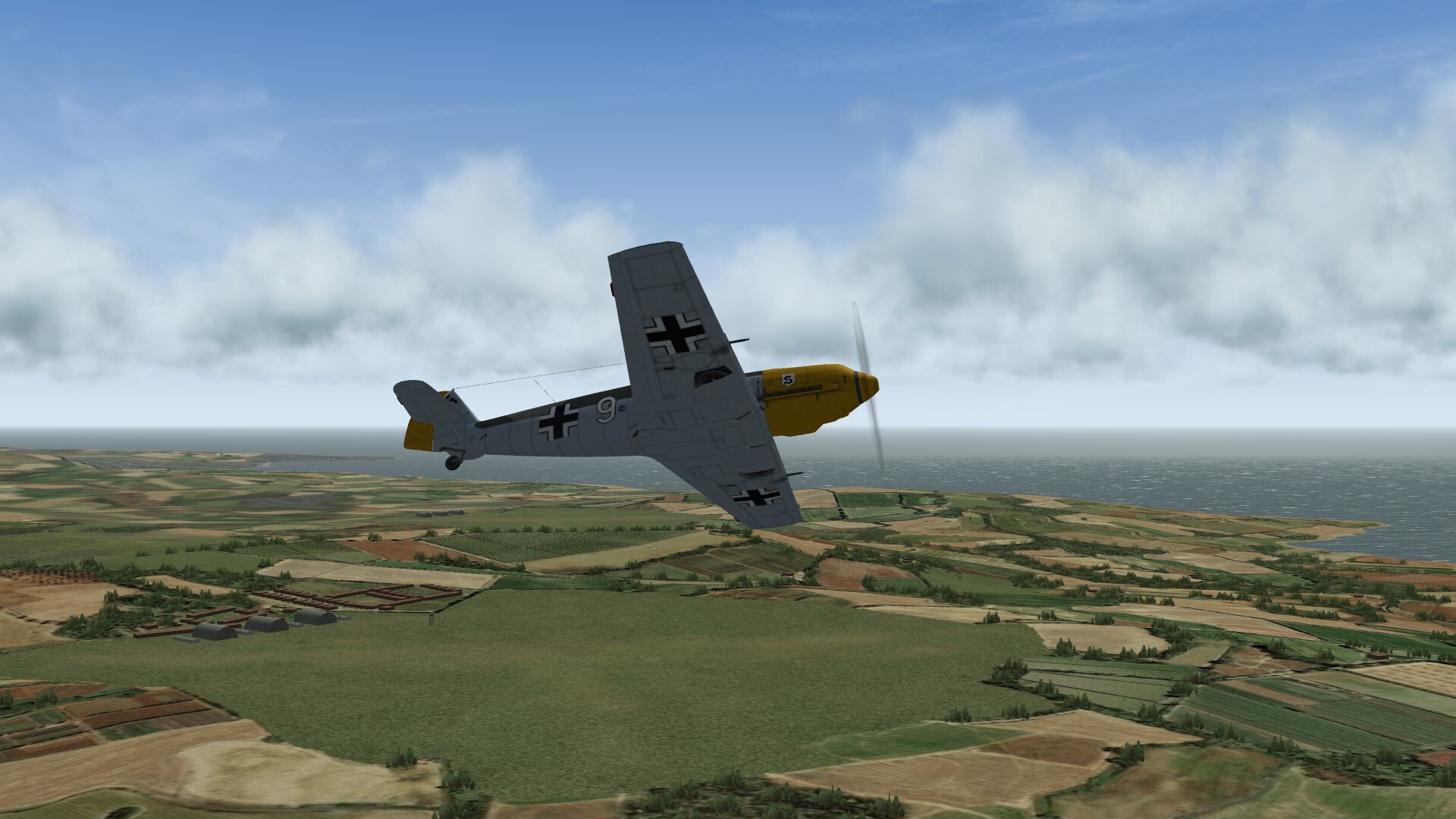
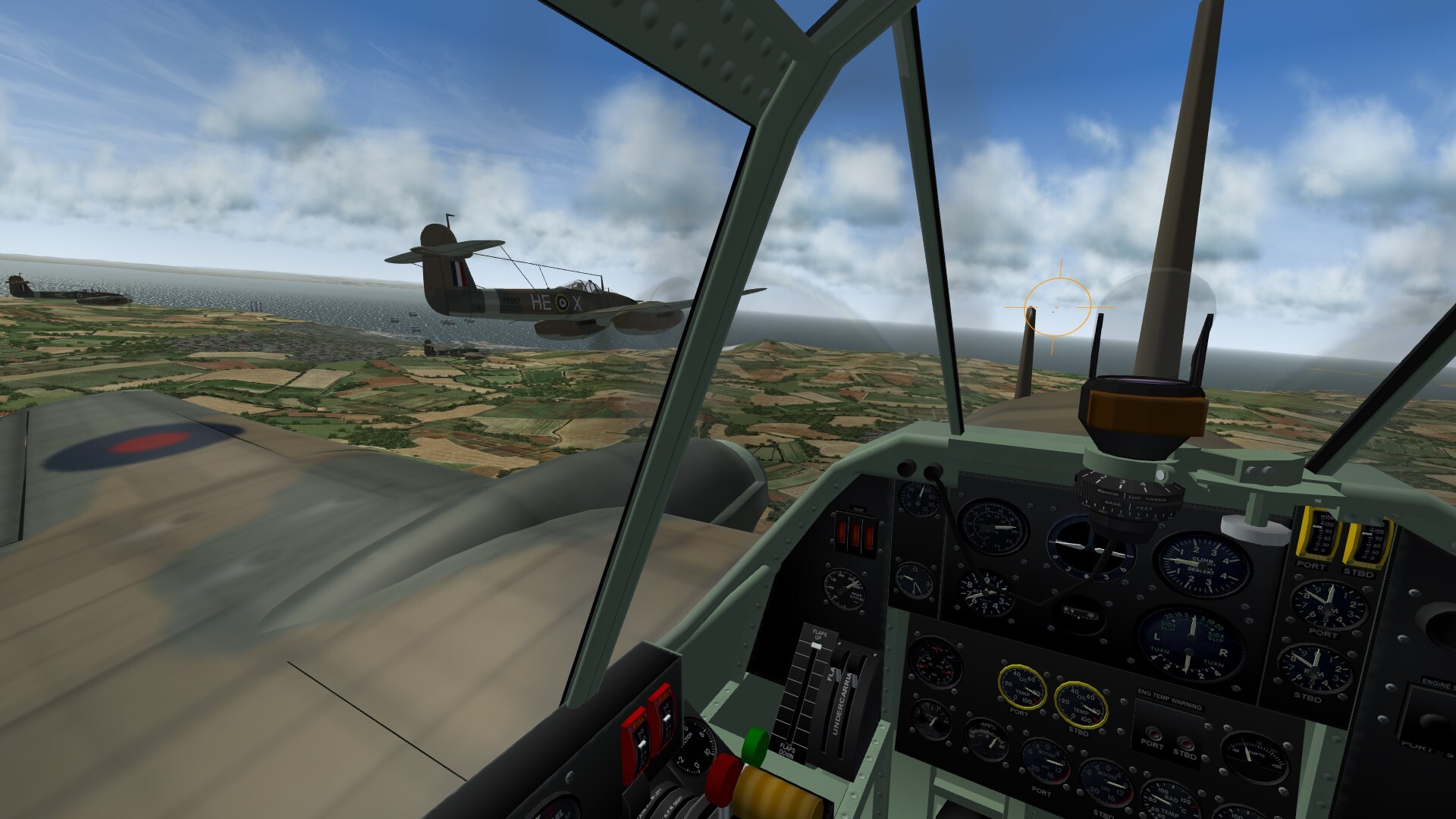
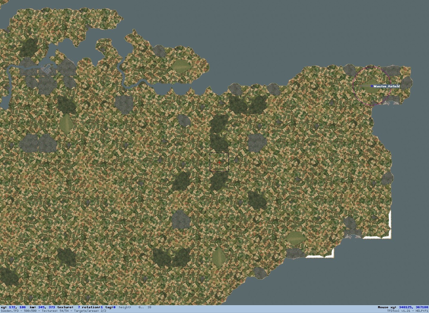
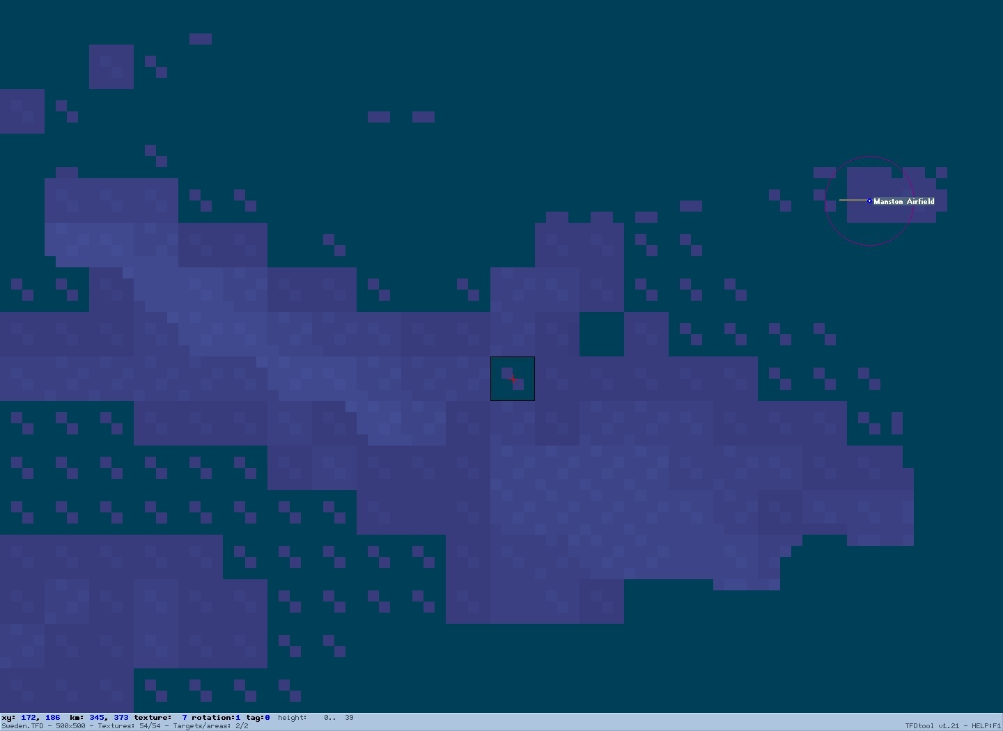
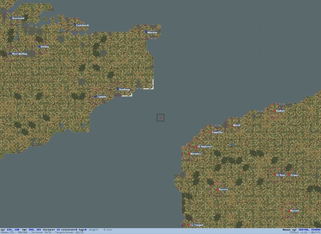
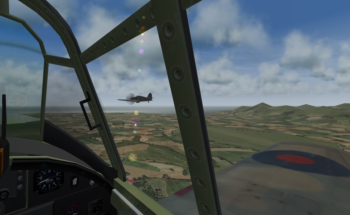
I described in previous threads how my interest in SF2 has been revived over the past year by discovering how to fly as a wingman, how to drop the 3D clouds to a more realistic altitude, and how to model small low-lying areas like the Baltic islands manually, without using the horizontally skewed elevation data provided by DEMs. My last thread showed how escaping the constraints of automatic terrain generation allowed me to construct a compact but flexible high resolution tileset based on the best of the wonderful artwork which other modders have created. As shown below, I have now completed the first stage of my associated project of gradually making my own manual tilemap for WW2 NW Europe. Besides avoiding horizontal distortion, this tilemap squeezes much more real land area into each tile than do other available terrains for the region. My manual modelling hence does not take impractically long, and I can fly entire wingman missions from takeoff to landing without unduly protracted transits. I am now ready to expand the modelled area gradually in all directions to allow longer missions than the brief cross-Channel hops possible already, as I build up my graphically far improved echo of the European Air War sim which I enjoyed so much 3 decades ago. I have made two main improvements since my last report. First, I decided to change horses again before it was too late by shifting to a new reference map made from a patchwork of screenshots from the online elevation maps at https://en-gb.topographic-map.com/, with the top contour locked at 1000 metres for consistency. As shown below, this makes it easier to select the base height of each tile, in conjunction with a zoomable live copy of the map alongside to show more precise contours. I have now standardised on 2 raised points on each tile, to create just the right amount of rolling terrain on all tiles except those showing watercourses, airfields or flat fenland or built-up areas. The road and rail lines on the reference map allow me to correlate with the live elevation map and with other zoomable live and satellite maps showing towns, airfields and vegetation. My second improvement has been to make my airfields many times smaller than the multi-tile monsters which dominate most SF2 terrains. As shown below in my representative selection of the several real airfields crammed behind Cap Gris Nez in 1940 to maximise the reach of the Bf 109, I now confine airfields to just the 4 central squares of their single 16 square tile. Not only does this make them look much less overscale on my reduced scale terrain, but it also allows the other 12 squares of the tile to slope up or down as shown here. By tracing runways diagonally rather than orthogonally, I keep them long enough to allow even 4 engine bombers to take off and land successfully if the data file constraint is removed. Deciding which of the many thousands of WW2 airfields to include on my terrain is hard (particularly in view of the many changes across this long conflict), but Henry Deng’s research collected at https://www.ww2.dk/lwairfields.html is of invaluable assistance, helping even to choose which side of each airfield to put my generic buildings. I have now switched my horizon distance setting back to ‘far’ since this makes my mass of small TOD objects look much better, at the cost of visibility on my reduced scale terrain being far greater than it would be in real life. I am currently using my new arena as a sandbox for a wide range of combat missions like those which I flew over published terrains as shown in my previous threads. The picture below shows our Whirlwind flight outbound past the radar masts and balloon barrage of Dover for a strafing run on Marquise in spring 1941. On my reduced scale terrain, the entire sortie from takeoff to landing back at Manston takes just 15 minutes. I have slashed the accuracy and warhead weight of low level flak so that such missions typically leave one friendly plane damaged, posing the added challenge of nursing the crippled craft back to base. I love the ability to tailor SF2 and its many mods to my personal preferences in this way, and having complete flexibility to shape my new NW Europe terrain adds greatly to my enjoyment of this classic sim. Eventually, I hope to return to the Baltic and to modify published artwork into a high resolution seasonal tileset with which to model the equally classic arena around Leningrad, as the kernel of another reduced scale manual terrain for aerial battles between Finland, Germany and the USSR.


- 11 replies
-
- 10
-
-
- manual terrain
- nw europe
- (and 2 more)
-
Experimenting with different aircraft types led me to discover a whole new way of enjoying my evolving WW2 terrain. The ungainly Lysander rarely flew in formation, so I cannot enjoy cockpit and external views simultaneously, but I decided instead to see if I could recreate its characteristic hedge-hopping clandestine night missions taking agents and arms to support the French resistance. In my first attempt I could see nothing except my own instruments, but luckily I persevered and changed the date by 2 weeks. SF2 has a wonderfully accurate sky dome, and sure enough, the full moon now gave just enough illumination for me to glimpse fields and trees once my eyes adjusted. I added basic runway lights to the INI file of my grass airfields, and I set up a training mission from Ronaldsway in which I would fly at low level across the island to Jurby, land and take off from the simulated strip prepared by the Maquis (as shown below), and navigate back to base for another night landing. The half hour sortie involved some close calls, but using a combination of my instruments and glimpses of the ground, I managed to return safely. Successfully navigating my route and flying low enough to escape detection without crashing provided ample continuing challenges equivalent to my usual endeavour to maintain close formation, and I look forward to simulating real clandestine missions of this kind as my terrain modelling extends across the Channel into France.

-
As usual, I have been enjoying short formation flights around the island, while tuning my graphics to strike the best balance between appearance and frame rates. I set Terrain Texture and Ground Object Density to Unlimited, to get the full benefit of Gepard’s high resolution tiles and my numerous TOD objects. Horizon Distance, by contrast, should actually be set to Near for my reduced scale terrain, but I compromise on Normal to stop nearby ground objects fading away too soon. Even at this Horizon setting, I decided to model the closest promontories on the Galloway peninsula, since they appear distinctly in the distance. I set Shadows to Medium, since otherwise ground object shadows pop distractingly on and off. As shown below by the island’s two northern airfields, I have made two generic airfield types using stock SF2 buildings – one with grass runways, and a more developed type using the single tile runway overlay in airfield3.lod. Both look good from above and allow me to taxi back to the hangars after each sortie. Even these single tile airfields are significantly too large for my reduced scale terrain, but at least they are preferable to the multi-tile airfields which are the norm in SF2.
-
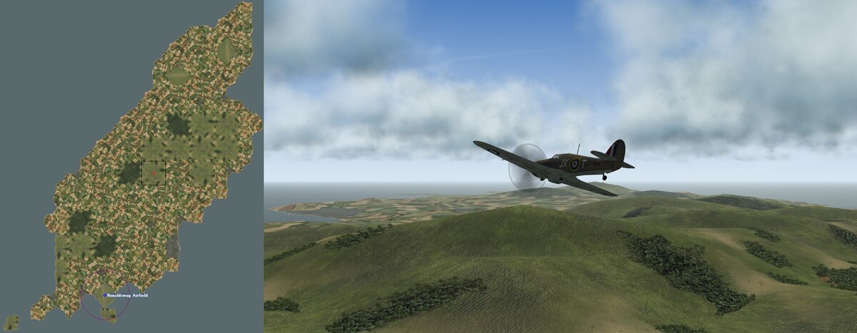
Having successfully modelled part of the main air arena in NW Europe, I decided to construct another island after all. The Isle of Man offered a great test to see if my manual approach could cope with hills 3 times higher than those in Kent, and its isolated location in the middle of the Irish Sea meant that no more terrain would be needed to model the many training sorties flown by the RAF from its wartime bases at Jurby, Ronaldsway and Andreas. As shown below, my new tileset came into its own in capturing the island’s geography far better than with standard SF2 tilesets, despite using only 85 tiles due to the reduced scale of my terrain. Douglas is the only town warranting an urban tile, but I was delighted that I could show the smaller coastal settlements of Ramsey, Peel, Laxey, Onchan, Port Erin and Castletown using port villages on my farmland tiles. As I expected, creating the HFD proved the biggest hurdle, and it took a lot of trial and error before I realised that the most practical solution was to construct a third ‘noise’ template for substantial hills, this time with 4 elevation points raised by 2 steps and a central point raised by 4 steps. Using this generic template, I could easily set the base height of each hill tile as before, and then polish the overall HFD by tweaking selected elevation points to smooth out unduly sharp angles or height differences. The picture below shows one of my first flights over my new terrain, with the Snaefell massif showcasing the uncultivated tiles which I have added to Gepard’s set, and with Douglas Bay and Ronaldsway airport in the distance bringing back memories of my regular childhood summer holidays on the island. I now know that I can model hills of this height if need be (albeit with some extra effort), so my evolving manual terrain is not limited entirely to the most low-lying parts of the European theatre.
-
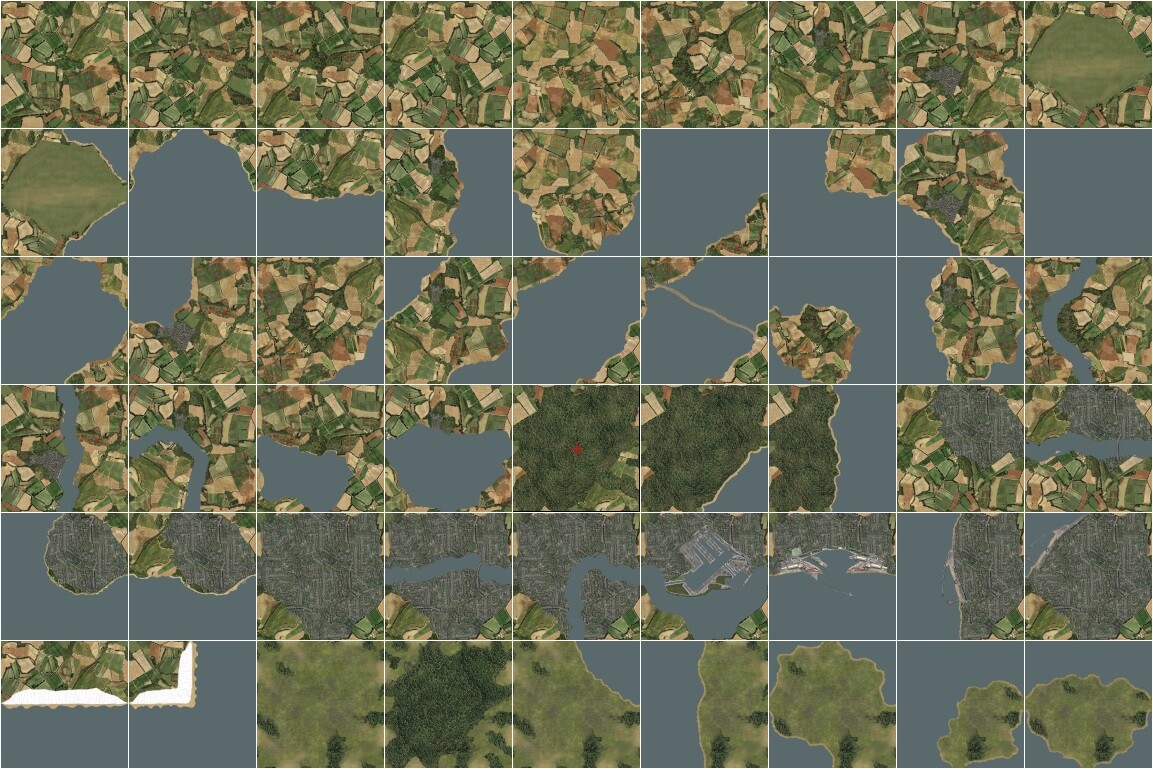
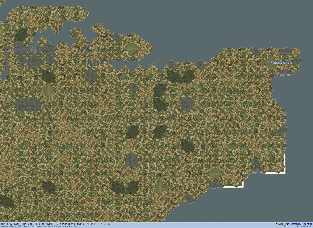
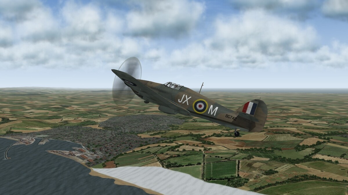
I described in my previous thread my experiments in creating a manual terrain for the northern half of the WW2 Eastern Front, to avoid the distortions caused in most published terrains by cartographic asymmetries in the DEM data at these high latitudes. It became increasingly evident that standard SF2 tilesets are a very blunt instrument for modelling real landscapes, and that ditching automatic terrain generation gave me the freedom to create a much more compact and flexible tile layout. I decided to do just this for my spin-off project of a truly reduced scale NW Europe terrain which would avoid the distortions and long E-W flight times of the classic EuroWW2 terrain and of Gepard’s more detailed Battle of Britain tileset. Since my terrain was designed to reduce flight times in my wingman experience missions by eventually squeezing the whole span from Brest to Berlin into a smaller playable area than Gepard used for the span from Brest to Dunkirk, it was vital to have tiles allowing higher resolution modelling than standard tilesets with their gentle stereotypical curves. After careful consideration, I decided to use Gepard’s lovely high res artwork as the basis for my redesigned tileset for my own private use. I confined my interventions to relatively simple graphical adjustments such as lightening water, forest and urban areas, creating my own shorelines, and cutting and pasting Gepard’s elements to construct my own preferred tile mix. I ended up with a compact set of just 54 tiles as shown below. The top row includes my standard single tile airfield and Gepard’s 8 farmland tiles including copses and small villages, which are randomly mixed and rotated using Gerwin’s invaluable TFD editor to form the default background of my terrain. Tiles 10 to 31 add water to these 9 basic tiles, with the key twist that my coastlines now run to the middle of each edge. This allows me to create narrow channels and isthmuses and to complement the standard coasts with ‘bays’ and ‘points’ which touch the middle of other edges, giving greater flexibility in mirroring real coastlines and allowing optional junctions with lakes and rivers or with small island tiles to create larger islands or peninsulas. Tiles 32 to 45 add woods and built-up areas to the basic tiles, with the key refinement that every edge retains the same mix of fields and copses as on Gepard’s farmland tiles, so they may be placed individually or in fully flexible clumps with the edges representing forest clearings or city parks. The bottom row adds a couple of tiles for the chalk cliffs on both sides of the Channel, and a selection of uncultivated tiles adapted from the high res Grass Base tile in Sundowner’s Photo Real UK Terrain, so that hills and moors need not be shown by unbroken woodland. Instead of starting with peripheral islands as in my Eastern Front project, I decided to leap straight to the heart of the WW2 action as shown below by modelling the ‘front line county’ of Kent. My approach of scrolling and zooming Google Maps to complement my Google-based reference map worked well, and my reshaped tileset came into its own in mirroring the intricacies of the north Kent coast and letting woods and towns appear correctly despite the much reduced scale of my terrain. I have included the 3 forward airfields of Manston, Hawkinge and Lympne, as well as the Coastal Command fields at Eastchurch and Detling. Although Kent is only a tiny percentage of the entire playable area, the ease of modelling the Channel itself means that it is already possible for me to fly intercept sorties from Manston. Filling out East Sussex and the Pas de Calais in similar fashion will allow me to model plenty of short range Axis or Allied missions from 1940 to 1944, as I seek to recapture with updated graphics some of the fun I had with European Air War nearly 3 decades ago. As Gepard said in my previous thread, it would be impossibly tedious to adjust 16 elevation points per tile manually, even if the data were to hand. However, as shown below I have now refined my more practical approach of raising entire tiles using Gerwin’s editor, by first copying and pasting generic ‘noise’ into all tiles not representing flat marshland. I add 2 raised points for rolling farmland, or 4 raised points for hills. I use unusually large height steps of 39 metres each, so in the low northern European plains to which my manual approach is most suited, I need only to select one of a few different underlying heights for each tile, based on the zoomable elevation maps available at https://en-us.topographic-map.com/. After careful experimentation, I now understand the intriguingly asymmetric procedures which SF2 uses to generate slopes, so I can make selective interventions around coasts, rivers or airfields or to smooth the course of steep slopes like the North Downs escarpment below. My generic noise masks the orthogonal nature of my smaller height variations, and makes treetop flights over my terrain a truly immersive and exhilarating affair. I still do not fully understand the tangled nuances of TOD objects, but after an extensive search I found a compatible set of tree and building TODs in ShrikeHawk’s Continuation War conversion which I could adapt for my purposes. I halved the height of the tree clumps to give a more realistic sense of speed, and I darkened the buildings to blend with Gepard’s tiles and reflect soot-blackened 1940s Europe. I employ only a tiny variety of these small TOD objects, but through assiduous use of Moe’s TOD editor I have keyed them fully to Gepard’s lovely tile artwork in such large numbers that I often reach the 10,000 vertex limit per tile (for instance when combining the low square blocks to represent warehouses and the like). I have already logged many hours in my trusty Hurricane to check and simply enjoy my evolving terrain, and the picture below shows me overflying the iconic Dover cliffs with the rolling Kent hills in the distance. I do not even try to match the huge variety of unique tiles and objects created by Gepard and others. My focus lies instead on combining the best basic elements from their work to create a simple, immersive and graphically striking generic terrain system which fits with my own idiosyncratic preferences and which I may extend gradually to cover other areas of NW Europe as time allows.

-
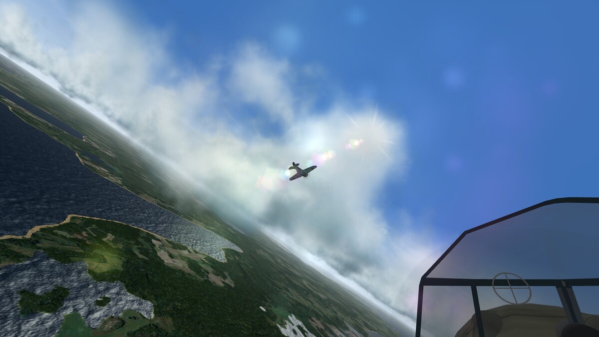
Much of the fun I have with SF2 stems from the sheer joy of vicarious exploration and virtual formation flight in classic warplanes. The picture below shows me struggling to follow my leader’s manoeuvring I-16 through the clouds above the NW tip of Saaremaa, while the morning sun sparkles on the bays and lakes below. I also love how radically this theatre changes across the seasons, as I saw myself when I visited Helsinki, Tallinn and Narva a few winters ago. My terrain will eventually allow me to model the summer battles which took place on the Finnish front in 1941 and 1944, as well as bringing the frozen world of Baltika’s North Cape terrain down to classic winter battlegrounds like Schlisselburg, Demyansk, Velikie Luki and Moscow.
-
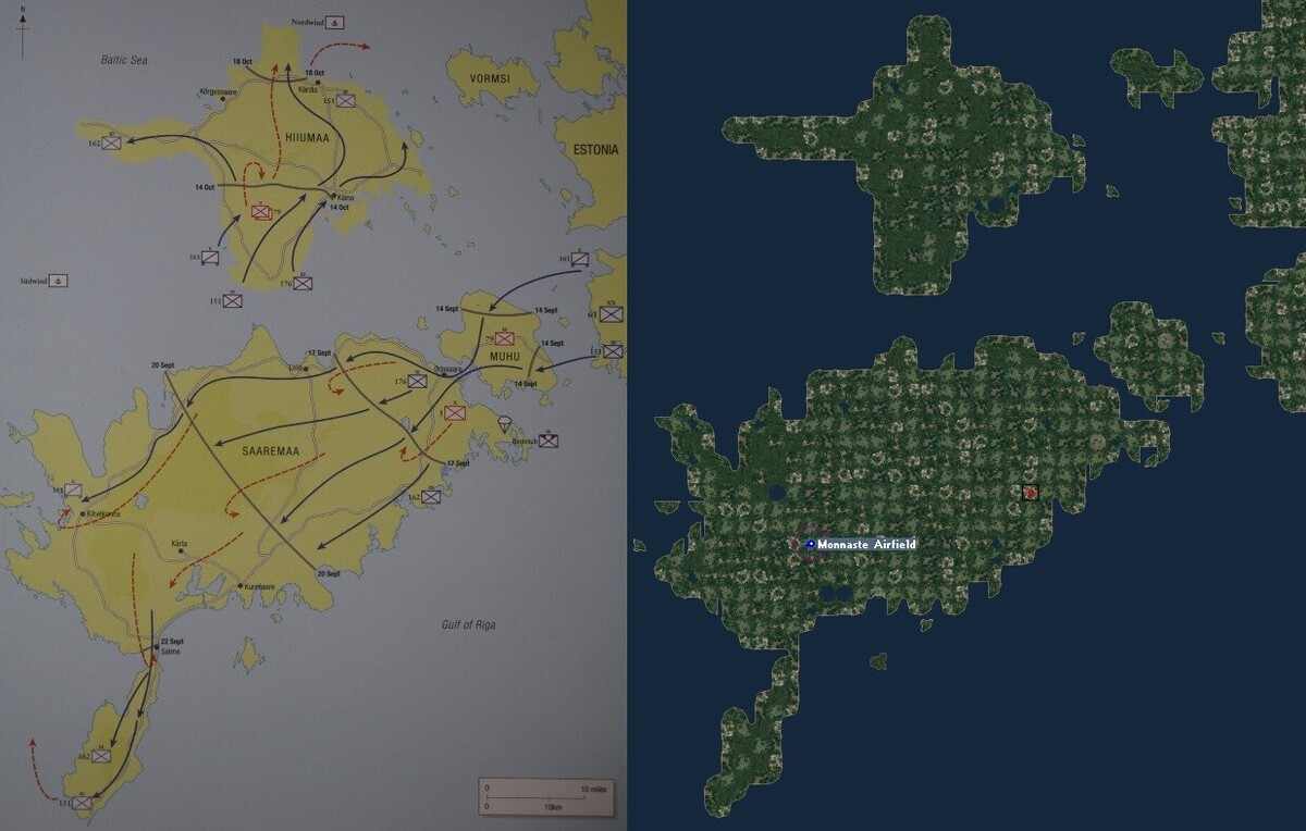
As shown below, I have now completed the Estonian islands as the first step in (very) gradually filling out the playable area of my manual Eastern Front terrain. Using Google maps alongside a square window for Gerwin’s editor worked well, with a blurrier map based on the same Google data underneath the tilemap for direct reference. The detailed Google map helps in modelling small lakes and islands, and its satellite view is invaluable in identifying the minority of named settlements which actually deserve a town or village tile, but for forests I found it easiest to scatter forest tiles (as seen below on Hiiumaa) in those areas marked as heavily wooded on the zoomed out Google map. Two improvements since my Gotland trial have made a big difference – I used my hard-won TGA editing experience to double the number but halve the height of the overscale 2D trees, and I raised most non-coastal tiles one step before adding specific relief on top. This makes low level flight exhilirating thanks to the far better sense of speed and natural contours. Henry de Zeng’s website details several primitive airfields on the islands in 1941. That shown at Monnuste was used by Soviet bombers as a forward base for retaliating against East Prussia after the mainland airfields had been overrun, and this attracted several raids by the Luftwaffe. (Primitive grass strips like these may be rotated by retaining a small runway as the first object in the airfield’s targets.ini entry, but commenting out the runway’s Modelname in the types.ini so it does not appear in the sim.) I already have enough completed terrain to host several interesting combat missions, including Soviet interception of German bombers flying in from Kuusiku south of Tallinn or Luftwaffe close support missions from a captured forward strip such as Monnuste during the 2 week battle for the narrow Sorve peninsula or the follow-up invasion of Hiuumaa. I may go on to model more of Estonia, or I may leap first to another vignette such as the Continuation War pocket battle at Sortavala north of Lake Ladoga in July-August 1941. Either way, my approach of gradually filling out my terrain while enjoying atmospheric historical wingman missions along the way is working gratifyingly well so far.
-
Many thanks. My terrain projects are currently veering away from small but detailed full scale vignettes like Gotland, and towards reduced scale terrains which will make recreation of longer range missions more practical within my real time approach. As I said, I have taken advantage of my shift to Google maps by extending the scope of my Eastern Front terrain south to Warsaw and east to Moscow, while retaining the standard 1000 km pattern. For a possible follow-up project on the similarly low lying region of NW Europe I have gone even further, creating a Google reference map whose nominally 800 km wide playable area stretches from Brest to Berlin and from St Nazaire to Kristiansand. This will allow much less protracted sorties than on the standard EuroWW2 terrain, whose 1500 km dimensions mean that it is actually full scale along the E-W axis (just like the Norway terrain). The corollary is, of course, that my tilemap will have a much lower resolution, but this has the significant benefit that it makes it more practical for me to create each successive stage of the terrain, starting with short cross-Channel hops and building towards 8th Air Force raids on the Biscay U-boat bases and on Germany itself. First, I will hone my approach on the Baltic, which is looking a bit less intimidating thanks to its own intermediate scale reduction.
-
Yes, the fun (and learning experience) lie at least as much in the terrain creation itself as in the resulting sorties. Although I have barely scratched the surface of the huge range of missions which can be flown across the many published terrains, it is satisfying to do it oneself for a change. As I said, I won't be able to post my own effort, and my aim in this thread was rather to inspire others to tweak terrains for personal use if desired, to create their own preferred 'sandbox' using the wonderful flexibility of SF2.
-
Thanks for explaining how the lovely Norway terrain overcomes the warping problem. I have flown over it often, but unfortunately, combat missions across the North Sea and back take much longer than fits with my real time approach. My current focus on the Eastern Front stems in part from the greater proximity of the opposing forces at any one time. I just read that Stukas sometimes managed 4 complete attack sorties within 2 hours. I tried such sorties last night, and dive bombing is well modelled from my own pilot's perspective. Getting my AI colleagues to do it is not so straightforward...
-
My experience with Gotland shows that one can fill in just a small proportion of a standard sized terrain, and have many enjoyable flights there. The area can be kept nice and central, well away from the wall. However, I am now discovering the severe limits of my old-fashioned Times map, through detailed perusal of the satellite view on Google maps. I had naively assumed that the Times cartographers had selected settlements based on size. It turns out that some are significant small towns but others are barely discernible in real life, having just a few scattered houses. The ideal instead would be to have the Google satellite view linked to Gerwin's editor, so it could be panned and zoomed in conjunction with the tile map. That way one could place town, lake and forest tiles exactly where appropriate. Roads are clearly visible in this satellite view, but small rivers are far harder to spot, and in hindsight most of those marked on the Times map are unworthy of representation. I clearly need to rethink my approach before proceeding with my manual terrain project. I think I will ditch the Times map and patch together a reference map instead from screen grabs of the zoomed out Google map. I will also narrow the width of Gerwin's editor so that I can run it side by side with an internet window showing the Google satellite view or the online elevation map I mentioned. These may be panned and zoomed independently to focus in on the area I am currently editing. That way I won't need to squint to discern the real terrain (except rivers), and I can gradually build up a representation which is as accurate as the severe limitations of an SF2 tileset allow. I will probably take the opportunity to reduce the scale a little more so that the playable area extends from Warsaw to Moscow, giving ample scope for scenarios on the northern half of the Eastern Front. Gotland has served a very useful purpose as a trial, but I have no intention of spending any more effort on the 36% of any SF2 map which is inaccessible - it will be hard enough to fill out more than a small proportion of the central area using my manual technique!
-
Thanks for telling us. I did wonder if editing the HFD bitmap to remove the distortion would work. It is well worth trying this if I get the chance. In the meantime, I am enjoying the freedom in my current manual project to create tiles which would stymie the automatic tile placement system. I have now added a few dozen extras in total (all with summer and winter versions), by tweaking the existing tiles which I have cannibalised. These additions make it a lot easier to model real features such as narrow peninsulas or lakes near the coast. I realised today that Google maps are more useful than satellite images in identifying where to place lakes or dense forests. (Zooming out a little helps with the latter, since it reduces the confusing welter of intermediate indications.) I have now added some forests on the south and east coasts of my Gotland model, as well as 8 new single- or multi-tile lakes in addition to the one shown on my Times map. The Times map is still better for showing rivers and for deciding which of the many settlements of varying sizes it is worth including in my terrain. I will never approach the level of your gorgeous Italy terrain with its bespoke lakes etc., but I have now achieved enough in this initial trial of my manual technique to be able to move on to model real air battle arenas in Estonia and elsewhere. I searched today for information on WW2 airfields in the Baltic region, and I was amazed by how much is available online. Henry de Zeng has made a stellar contribution at http://www.ww2.dk/lwairfields.html by posting his encyclopaedic research into Luftwaffe airfields in every theatre. This confirms that many more airfields existed than are modelled in SF2 terrains, but that the great majority were simple cleared squares of grass or dirt rather than big and elaborate constructions like those needed by the jets which are SF2's primary focus. As an experiment, I placed a single grass tile without trees in my Gotland model, and created an airfield there in my targets.ini with no objects whatsoever, referring to a barebones airfield.ini with nothing except takeoff and parking info. The field worked a treat, and it is easy to add minimalist airfields like this in any WW2 terrain to allow fighters and attack aircraft to operate from just behind the front lines.