pagsab
-
Posts
50 -
Joined
-
Last visited
-
Days Won
1
Content Type
Profiles
Forums
Gallery
Downloads
Store
Everything posted by pagsab
-
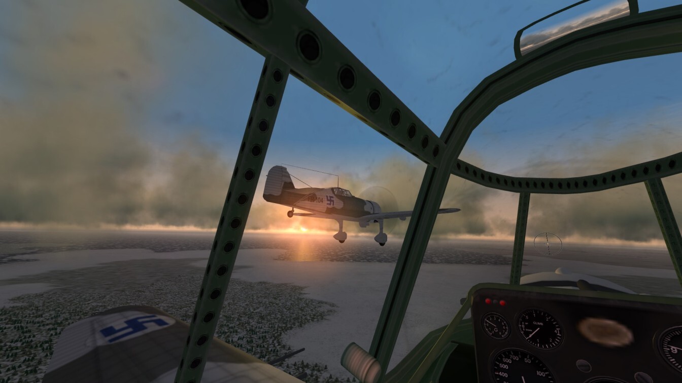
Experimenting with different aircraft types led me to discover a whole new way of enjoying my evolving WW2 terrain. The ungainly Lysander rarely flew in formation, so I cannot enjoy cockpit and external views simultaneously, but I decided instead to see if I could recreate its characteristic hedge-hopping clandestine night missions taking agents and arms to support the French resistance. In my first attempt I could see nothing except my own instruments, but luckily I persevered and changed the date by 2 weeks. SF2 has a wonderfully accurate sky dome, and sure enough, the full moon now gave just enough illumination for me to glimpse fields and trees once my eyes adjusted. I added basic runway lights to the INI file of my grass airfields, and I set up a training mission from Ronaldsway in which I would fly at low level across the island to Jurby, land and take off from the simulated strip prepared by the Maquis (as shown below), and navigate back to base for another night landing. The half hour sortie involved some close calls, but using a combination of my instruments and glimpses of the ground, I managed to return safely. Successfully navigating my route and flying low enough to escape detection without crashing provided ample continuing challenges equivalent to my usual endeavour to maintain close formation, and I look forward to simulating real clandestine missions of this kind as my terrain modelling extends across the Channel into France.

-
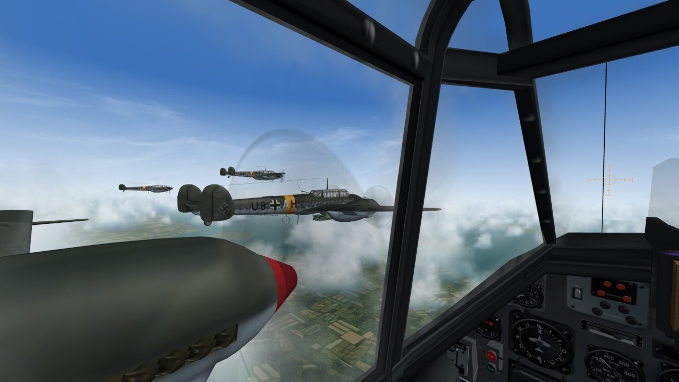
As usual, I have been enjoying short formation flights around the island, while tuning my graphics to strike the best balance between appearance and frame rates. I set Terrain Texture and Ground Object Density to Unlimited, to get the full benefit of Gepard’s high resolution tiles and my numerous TOD objects. Horizon Distance, by contrast, should actually be set to Near for my reduced scale terrain, but I compromise on Normal to stop nearby ground objects fading away too soon. Even at this Horizon setting, I decided to model the closest promontories on the Galloway peninsula, since they appear distinctly in the distance. I set Shadows to Medium, since otherwise ground object shadows pop distractingly on and off. As shown below by the island’s two northern airfields, I have made two generic airfield types using stock SF2 buildings – one with grass runways, and a more developed type using the single tile runway overlay in airfield3.lod. Both look good from above and allow me to taxi back to the hangars after each sortie. Even these single tile airfields are significantly too large for my reduced scale terrain, but at least they are preferable to the multi-tile airfields which are the norm in SF2.
-
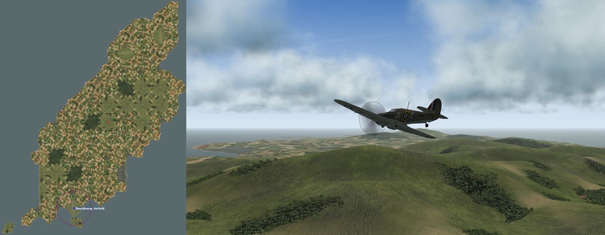
Having successfully modelled part of the main air arena in NW Europe, I decided to construct another island after all. The Isle of Man offered a great test to see if my manual approach could cope with hills 3 times higher than those in Kent, and its isolated location in the middle of the Irish Sea meant that no more terrain would be needed to model the many training sorties flown by the RAF from its wartime bases at Jurby, Ronaldsway and Andreas. As shown below, my new tileset came into its own in capturing the island’s geography far better than with standard SF2 tilesets, despite using only 85 tiles due to the reduced scale of my terrain. Douglas is the only town warranting an urban tile, but I was delighted that I could show the smaller coastal settlements of Ramsey, Peel, Laxey, Onchan, Port Erin and Castletown using port villages on my farmland tiles. As I expected, creating the HFD proved the biggest hurdle, and it took a lot of trial and error before I realised that the most practical solution was to construct a third ‘noise’ template for substantial hills, this time with 4 elevation points raised by 2 steps and a central point raised by 4 steps. Using this generic template, I could easily set the base height of each hill tile as before, and then polish the overall HFD by tweaking selected elevation points to smooth out unduly sharp angles or height differences. The picture below shows one of my first flights over my new terrain, with the Snaefell massif showcasing the uncultivated tiles which I have added to Gepard’s set, and with Douglas Bay and Ronaldsway airport in the distance bringing back memories of my regular childhood summer holidays on the island. I now know that I can model hills of this height if need be (albeit with some extra effort), so my evolving manual terrain is not limited entirely to the most low-lying parts of the European theatre.
-
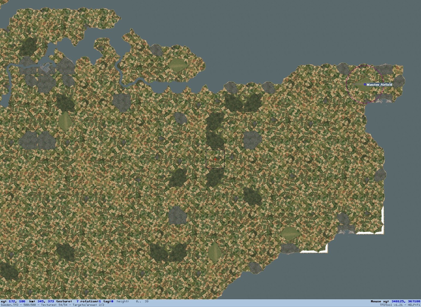
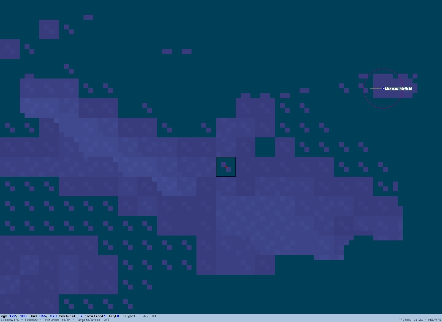
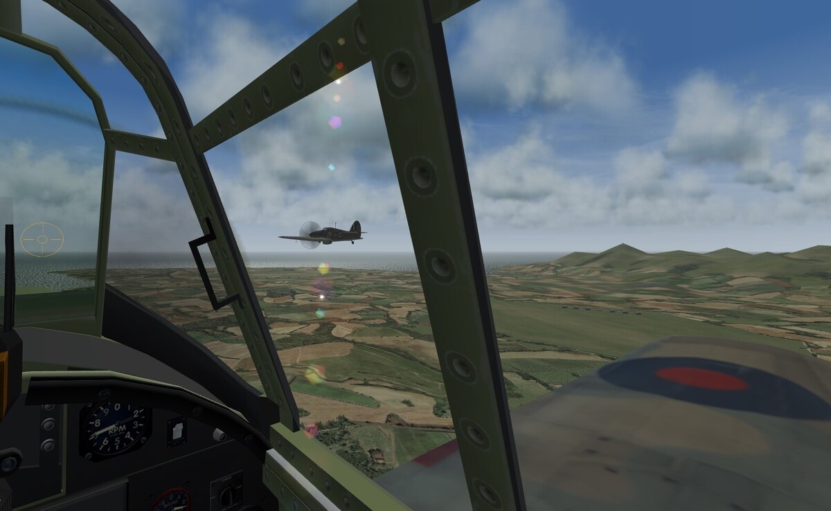
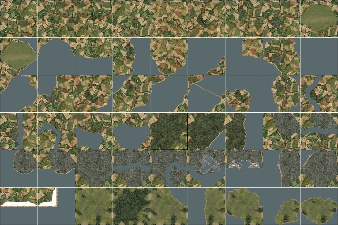
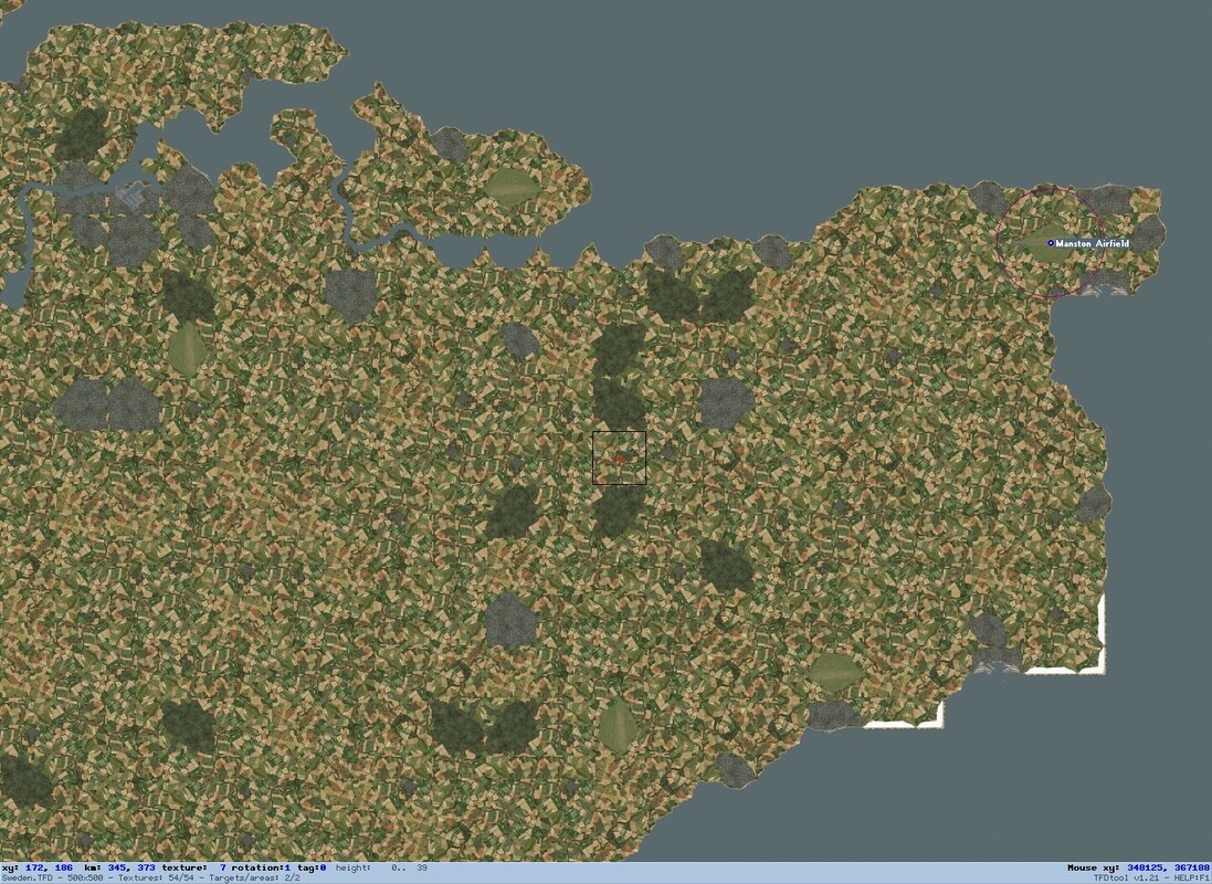
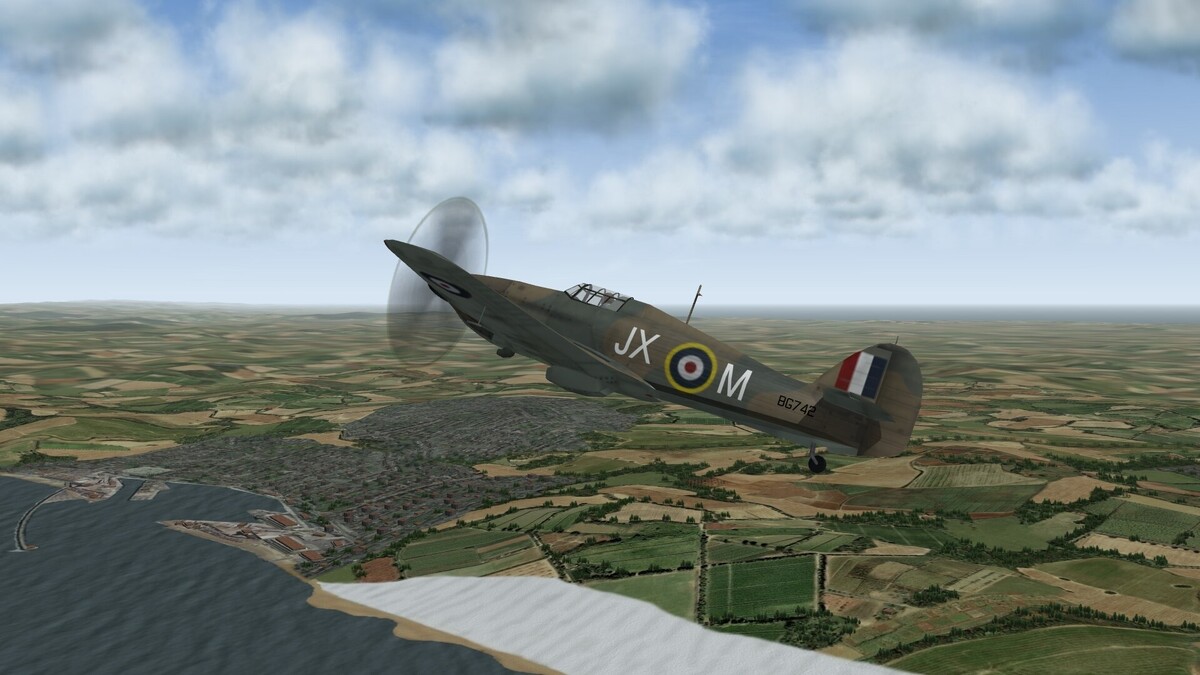
I described in my previous thread my experiments in creating a manual terrain for the northern half of the WW2 Eastern Front, to avoid the distortions caused in most published terrains by cartographic asymmetries in the DEM data at these high latitudes. It became increasingly evident that standard SF2 tilesets are a very blunt instrument for modelling real landscapes, and that ditching automatic terrain generation gave me the freedom to create a much more compact and flexible tile layout. I decided to do just this for my spin-off project of a truly reduced scale NW Europe terrain which would avoid the distortions and long E-W flight times of the classic EuroWW2 terrain and of Gepard’s more detailed Battle of Britain tileset. Since my terrain was designed to reduce flight times in my wingman experience missions by eventually squeezing the whole span from Brest to Berlin into a smaller playable area than Gepard used for the span from Brest to Dunkirk, it was vital to have tiles allowing higher resolution modelling than standard tilesets with their gentle stereotypical curves. After careful consideration, I decided to use Gepard’s lovely high res artwork as the basis for my redesigned tileset for my own private use. I confined my interventions to relatively simple graphical adjustments such as lightening water, forest and urban areas, creating my own shorelines, and cutting and pasting Gepard’s elements to construct my own preferred tile mix. I ended up with a compact set of just 54 tiles as shown below. The top row includes my standard single tile airfield and Gepard’s 8 farmland tiles including copses and small villages, which are randomly mixed and rotated using Gerwin’s invaluable TFD editor to form the default background of my terrain. Tiles 10 to 31 add water to these 9 basic tiles, with the key twist that my coastlines now run to the middle of each edge. This allows me to create narrow channels and isthmuses and to complement the standard coasts with ‘bays’ and ‘points’ which touch the middle of other edges, giving greater flexibility in mirroring real coastlines and allowing optional junctions with lakes and rivers or with small island tiles to create larger islands or peninsulas. Tiles 32 to 45 add woods and built-up areas to the basic tiles, with the key refinement that every edge retains the same mix of fields and copses as on Gepard’s farmland tiles, so they may be placed individually or in fully flexible clumps with the edges representing forest clearings or city parks. The bottom row adds a couple of tiles for the chalk cliffs on both sides of the Channel, and a selection of uncultivated tiles adapted from the high res Grass Base tile in Sundowner’s Photo Real UK Terrain, so that hills and moors need not be shown by unbroken woodland. Instead of starting with peripheral islands as in my Eastern Front project, I decided to leap straight to the heart of the WW2 action as shown below by modelling the ‘front line county’ of Kent. My approach of scrolling and zooming Google Maps to complement my Google-based reference map worked well, and my reshaped tileset came into its own in mirroring the intricacies of the north Kent coast and letting woods and towns appear correctly despite the much reduced scale of my terrain. I have included the 3 forward airfields of Manston, Hawkinge and Lympne, as well as the Coastal Command fields at Eastchurch and Detling. Although Kent is only a tiny percentage of the entire playable area, the ease of modelling the Channel itself means that it is already possible for me to fly intercept sorties from Manston. Filling out East Sussex and the Pas de Calais in similar fashion will allow me to model plenty of short range Axis or Allied missions from 1940 to 1944, as I seek to recapture with updated graphics some of the fun I had with European Air War nearly 3 decades ago. As Gepard said in my previous thread, it would be impossibly tedious to adjust 16 elevation points per tile manually, even if the data were to hand. However, as shown below I have now refined my more practical approach of raising entire tiles using Gerwin’s editor, by first copying and pasting generic ‘noise’ into all tiles not representing flat marshland. I add 2 raised points for rolling farmland, or 4 raised points for hills. I use unusually large height steps of 39 metres each, so in the low northern European plains to which my manual approach is most suited, I need only to select one of a few different underlying heights for each tile, based on the zoomable elevation maps available at https://en-us.topographic-map.com/. After careful experimentation, I now understand the intriguingly asymmetric procedures which SF2 uses to generate slopes, so I can make selective interventions around coasts, rivers or airfields or to smooth the course of steep slopes like the North Downs escarpment below. My generic noise masks the orthogonal nature of my smaller height variations, and makes treetop flights over my terrain a truly immersive and exhilarating affair. I still do not fully understand the tangled nuances of TOD objects, but after an extensive search I found a compatible set of tree and building TODs in ShrikeHawk’s Continuation War conversion which I could adapt for my purposes. I halved the height of the tree clumps to give a more realistic sense of speed, and I darkened the buildings to blend with Gepard’s tiles and reflect soot-blackened 1940s Europe. I employ only a tiny variety of these small TOD objects, but through assiduous use of Moe’s TOD editor I have keyed them fully to Gepard’s lovely tile artwork in such large numbers that I often reach the 10,000 vertex limit per tile (for instance when combining the low square blocks to represent warehouses and the like). I have already logged many hours in my trusty Hurricane to check and simply enjoy my evolving terrain, and the picture below shows me overflying the iconic Dover cliffs with the rolling Kent hills in the distance. I do not even try to match the huge variety of unique tiles and objects created by Gepard and others. My focus lies instead on combining the best basic elements from their work to create a simple, immersive and graphically striking generic terrain system which fits with my own idiosyncratic preferences and which I may extend gradually to cover other areas of NW Europe as time allows.

-
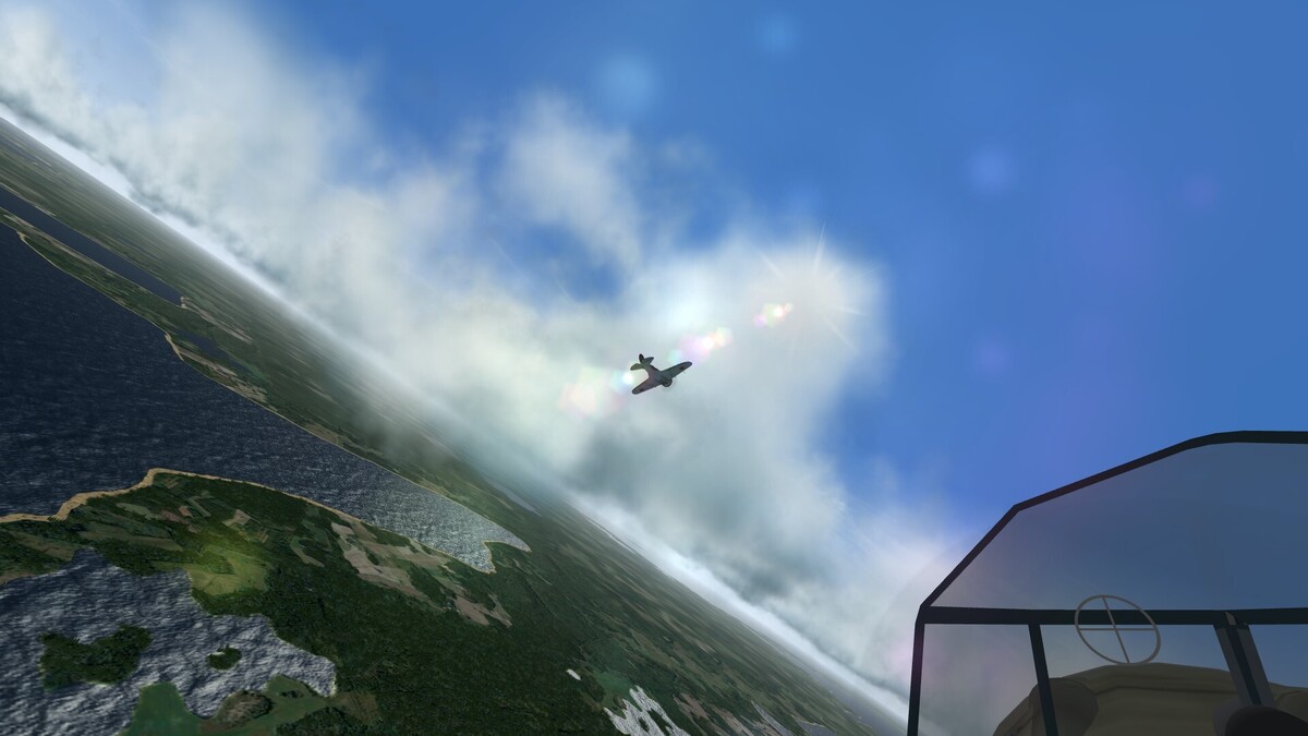
Much of the fun I have with SF2 stems from the sheer joy of vicarious exploration and virtual formation flight in classic warplanes. The picture below shows me struggling to follow my leader’s manoeuvring I-16 through the clouds above the NW tip of Saaremaa, while the morning sun sparkles on the bays and lakes below. I also love how radically this theatre changes across the seasons, as I saw myself when I visited Helsinki, Tallinn and Narva a few winters ago. My terrain will eventually allow me to model the summer battles which took place on the Finnish front in 1941 and 1944, as well as bringing the frozen world of Baltika’s North Cape terrain down to classic winter battlegrounds like Schlisselburg, Demyansk, Velikie Luki and Moscow.
-
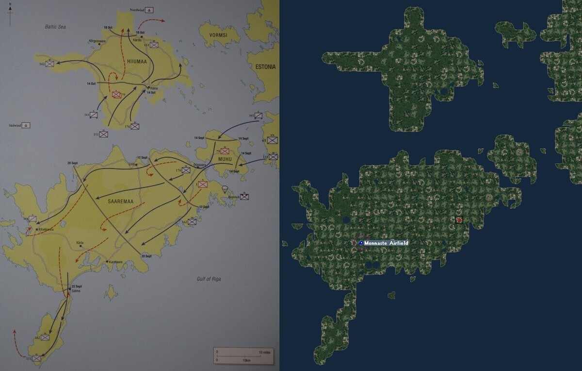
As shown below, I have now completed the Estonian islands as the first step in (very) gradually filling out the playable area of my manual Eastern Front terrain. Using Google maps alongside a square window for Gerwin’s editor worked well, with a blurrier map based on the same Google data underneath the tilemap for direct reference. The detailed Google map helps in modelling small lakes and islands, and its satellite view is invaluable in identifying the minority of named settlements which actually deserve a town or village tile, but for forests I found it easiest to scatter forest tiles (as seen below on Hiiumaa) in those areas marked as heavily wooded on the zoomed out Google map. Two improvements since my Gotland trial have made a big difference – I used my hard-won TGA editing experience to double the number but halve the height of the overscale 2D trees, and I raised most non-coastal tiles one step before adding specific relief on top. This makes low level flight exhilirating thanks to the far better sense of speed and natural contours. Henry de Zeng’s website details several primitive airfields on the islands in 1941. That shown at Monnuste was used by Soviet bombers as a forward base for retaliating against East Prussia after the mainland airfields had been overrun, and this attracted several raids by the Luftwaffe. (Primitive grass strips like these may be rotated by retaining a small runway as the first object in the airfield’s targets.ini entry, but commenting out the runway’s Modelname in the types.ini so it does not appear in the sim.) I already have enough completed terrain to host several interesting combat missions, including Soviet interception of German bombers flying in from Kuusiku south of Tallinn or Luftwaffe close support missions from a captured forward strip such as Monnuste during the 2 week battle for the narrow Sorve peninsula or the follow-up invasion of Hiuumaa. I may go on to model more of Estonia, or I may leap first to another vignette such as the Continuation War pocket battle at Sortavala north of Lake Ladoga in July-August 1941. Either way, my approach of gradually filling out my terrain while enjoying atmospheric historical wingman missions along the way is working gratifyingly well so far.
-
Many thanks. My terrain projects are currently veering away from small but detailed full scale vignettes like Gotland, and towards reduced scale terrains which will make recreation of longer range missions more practical within my real time approach. As I said, I have taken advantage of my shift to Google maps by extending the scope of my Eastern Front terrain south to Warsaw and east to Moscow, while retaining the standard 1000 km pattern. For a possible follow-up project on the similarly low lying region of NW Europe I have gone even further, creating a Google reference map whose nominally 800 km wide playable area stretches from Brest to Berlin and from St Nazaire to Kristiansand. This will allow much less protracted sorties than on the standard EuroWW2 terrain, whose 1500 km dimensions mean that it is actually full scale along the E-W axis (just like the Norway terrain). The corollary is, of course, that my tilemap will have a much lower resolution, but this has the significant benefit that it makes it more practical for me to create each successive stage of the terrain, starting with short cross-Channel hops and building towards 8th Air Force raids on the Biscay U-boat bases and on Germany itself. First, I will hone my approach on the Baltic, which is looking a bit less intimidating thanks to its own intermediate scale reduction.
-
Yes, the fun (and learning experience) lie at least as much in the terrain creation itself as in the resulting sorties. Although I have barely scratched the surface of the huge range of missions which can be flown across the many published terrains, it is satisfying to do it oneself for a change. As I said, I won't be able to post my own effort, and my aim in this thread was rather to inspire others to tweak terrains for personal use if desired, to create their own preferred 'sandbox' using the wonderful flexibility of SF2.
-
Thanks for explaining how the lovely Norway terrain overcomes the warping problem. I have flown over it often, but unfortunately, combat missions across the North Sea and back take much longer than fits with my real time approach. My current focus on the Eastern Front stems in part from the greater proximity of the opposing forces at any one time. I just read that Stukas sometimes managed 4 complete attack sorties within 2 hours. I tried such sorties last night, and dive bombing is well modelled from my own pilot's perspective. Getting my AI colleagues to do it is not so straightforward...
-
My experience with Gotland shows that one can fill in just a small proportion of a standard sized terrain, and have many enjoyable flights there. The area can be kept nice and central, well away from the wall. However, I am now discovering the severe limits of my old-fashioned Times map, through detailed perusal of the satellite view on Google maps. I had naively assumed that the Times cartographers had selected settlements based on size. It turns out that some are significant small towns but others are barely discernible in real life, having just a few scattered houses. The ideal instead would be to have the Google satellite view linked to Gerwin's editor, so it could be panned and zoomed in conjunction with the tile map. That way one could place town, lake and forest tiles exactly where appropriate. Roads are clearly visible in this satellite view, but small rivers are far harder to spot, and in hindsight most of those marked on the Times map are unworthy of representation. I clearly need to rethink my approach before proceeding with my manual terrain project. I think I will ditch the Times map and patch together a reference map instead from screen grabs of the zoomed out Google map. I will also narrow the width of Gerwin's editor so that I can run it side by side with an internet window showing the Google satellite view or the online elevation map I mentioned. These may be panned and zoomed independently to focus in on the area I am currently editing. That way I won't need to squint to discern the real terrain (except rivers), and I can gradually build up a representation which is as accurate as the severe limitations of an SF2 tileset allow. I will probably take the opportunity to reduce the scale a little more so that the playable area extends from Warsaw to Moscow, giving ample scope for scenarios on the northern half of the Eastern Front. Gotland has served a very useful purpose as a trial, but I have no intention of spending any more effort on the 36% of any SF2 map which is inaccessible - it will be hard enough to fill out more than a small proportion of the central area using my manual technique!
-
Thanks for telling us. I did wonder if editing the HFD bitmap to remove the distortion would work. It is well worth trying this if I get the chance. In the meantime, I am enjoying the freedom in my current manual project to create tiles which would stymie the automatic tile placement system. I have now added a few dozen extras in total (all with summer and winter versions), by tweaking the existing tiles which I have cannibalised. These additions make it a lot easier to model real features such as narrow peninsulas or lakes near the coast. I realised today that Google maps are more useful than satellite images in identifying where to place lakes or dense forests. (Zooming out a little helps with the latter, since it reduces the confusing welter of intermediate indications.) I have now added some forests on the south and east coasts of my Gotland model, as well as 8 new single- or multi-tile lakes in addition to the one shown on my Times map. The Times map is still better for showing rivers and for deciding which of the many settlements of varying sizes it is worth including in my terrain. I will never approach the level of your gorgeous Italy terrain with its bespoke lakes etc., but I have now achieved enough in this initial trial of my manual technique to be able to move on to model real air battle arenas in Estonia and elsewhere. I searched today for information on WW2 airfields in the Baltic region, and I was amazed by how much is available online. Henry de Zeng has made a stellar contribution at http://www.ww2.dk/lwairfields.html by posting his encyclopaedic research into Luftwaffe airfields in every theatre. This confirms that many more airfields existed than are modelled in SF2 terrains, but that the great majority were simple cleared squares of grass or dirt rather than big and elaborate constructions like those needed by the jets which are SF2's primary focus. As an experiment, I placed a single grass tile without trees in my Gotland model, and created an airfield there in my targets.ini with no objects whatsoever, referring to a barebones airfield.ini with nothing except takeoff and parking info. The field worked a treat, and it is easy to add minimalist airfields like this in any WW2 terrain to allow fighters and attack aircraft to operate from just behind the front lines.
-
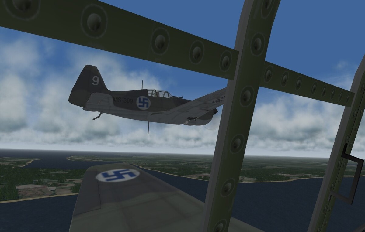
As I said in previous threads, my discovery of how to fly as a wingman has hugely increased my enjoyment of SF2, and it is even more fun over my own detailed terrain. I don't have any Swedish planes of the era, but I hypothesise that the Finns may have sent a few on detachment to Gotland in autumn 1940, to show solidarity with their Swedish allies from the Winter War after Stalin annexed the nearby Baltic States that summer. Here I am in a Morane Saulnier 406, enjoying a low level circuit of the island with my leader as we cross back from Faro to Gotland itself. The small port of Farosund is just above my wing, and to its right may be glimpsed one of the low hills I have added. ShrikeHawk's Continuation War conversion in the downloads section of this site is a good source of relevant files.
-
The warping problem certainly seems to have been avoided in a few terrains, notably Baltika's North Cape terrain despite its very high latitudes. Does anyone remember how?
-
Good question, Gepard. As I said, I prioritise avoiding horizontal distortion over a detailed heightfield, especially in low lying areas like these where the small elevation differences matter little except to soften the jarring appearance of pancake-flat terrain. Hence, I usually just raise entire tiles 1 or 2 steps above the default sea level, guided by side by side comparison with an elevation map like that shown below from the website I mentioned. (I can't simply replace the reference map with this elevation map when setting the heightfield, since its projection differs from my Times map.) Gerwin's editor does allow one to zoom in and adjust all 16 elevation points individually if desired, but I do this only to stop coastal hills lifting the sea, as seen below in the Hall peninsula or on the northern boundary of Visby airfield. My more impressionistic heightfield creation technique does not take that long compared to manually selecting and rotating tiles themselves - it is the latter which limits my method to small bespoke combat areas or isolated island bases such as Midway. DEMs are undoubtedly far quicker as vonBeerhofen said, though I agree that there is a special satisfaction in creating a terrain manually, where one can escape the limitations of the automatic system and add details like those I have mentioned. It should be entirely feasible in due course for me to fill out in my terrain the crucial 150 km wide arena between Oranienbaum and Lake Ladoga where the Nazis and Soviets confronted one another for over 2 years and where many bitter air battles too place.

-
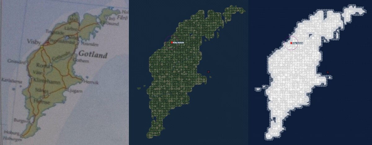
Terrain making in SF2 depends heavily on having a Digital Elevation Model to generate the height and tile fields required. However, I have been frustrated by the geographical distortions produced in so many SF2 terrains by the mismatch between E-W and N-S distances in the underlying DEMs, especially at higher latitudes. I hence decided to try doing without DEMs by making a terrain the old fashioned way, using maps whose projections minimise the distortions involved. My Times Comprehensive World Atlas has a double spread showing the Baltic States at 1:2,500,000, perfectly matching the standard 1000 km terrain square in SF2. I made a high resolution copy of this spread, including the margins so as to reduce the scale slightly and hence fit everything from the Pripet Marshes to Karelia within the 800 km playable area. I then imported this as a reference map into Gerwin’s wonderful TFD editor, along with blank HFD and TFD files from the TW terrain editor. To minimise effort, I cannibalised published tiles, objects and target files as much as possible, including the ice floes from Menrva’s Bering Straits terrain. I tweaked and augmented my tileset to create more villages and towns and to allow smaller islands and sharper promontories than with the gently curving standard tiles. Mue’s editor made it easy to amend TOD objects, but editing tile images and transparency proved maddeningly difficult until I finally found a way to do so through combined use of GIMP and an old copy of Photoshop Elements. Gerwin’s editor allows a selected mix of countryside tiles to be pasted and then rotated at random, but overlaying this generic background with more specific tiles is a daunting task given that even a standard 1000 km terrain includes a quarter of a million tiles! I opted to practise on the 130 km long Swedish island of Gotland, to perfect my techniques before moving to more central areas. Modelling the island was a very slow process of toggling between the reference and tile maps and selecting and rotating each tile in turn. Besides doing this along the coastlines (including an outer layer of coastal ice), I opted to model every settlement and small river shown on the Times map, though I drew the line at trying to add roads as well. The many satellite images accessible on the web will help in guiding the addition of dense forest and small lake tiles in those parts of the region where these features are more common. In this generally low lying terrain, it is easy to use Gerwin’s editor to add small height steps to entire tiles, to model the relief shown on the very useful elevation maps available at https://en-us.topographic-map.com/. The picture below shows my summer and winter versions of Gotland, alongside the matching part of the Times map on which they are based. If SF2 terrain creation were an all or nothing affair, I would give up now, since applying this tortuous process across the entire map would take an impossibly long time. However, by shifting Gotland temporarily east into the playable area, I have already flown dozens of terrain checking and wingman experience missions in classic 1940 planes over this island alone. Modelling western Estonia will allow recreation of air missions during the German assault on the Estonian islands in autumn 1941, and in due course I can add further parts of the region to allow my preferred short range real time missions to be flown there also. My terrain will remain purely for personal use due to its dependence on third party components, so it does not matter that I am unlikely ever to finish this ongoing project. The real benefit of my experience so far is that I now understand far more than I did before about the creation and modification of SF2 terrains. The knowledge only increases my respect for the makers of published terrains, while giving me a welcome ability to address perceived deficiencies should I wish to undertake the considerable effort required. I find maps and military geography especially fascinating, and making or amending SF2 terrains is a very satisfying way of studying the fine details of the real terrain over which the missions we model were flown.
-
The picture below shows the advantages for small airfields of using fewer tiles than for the original base in the background from which I cloned this trial airfield. It is easy to tweak existing bases if desired, by using Gerwin's tool to swap round the tiles and flatten all 4 remaining tiles at the same height, and then modifying the airfield's location slightly in the targets.ini. Importing airfields from other terrains is more involved, since besides amending the targets.ini you need to make sure to add all associated models to the types.ini and to your terrain and objects folders if need be. For multiplayer or campaign missions, you should probably avoid such tweaks in order to maintain commonality with the original published terrain, and you will need clear permission from the terrain's creators to share tweaked versions online. I prefer to share techniques and experience rather than files, so that other users may decide for themselves what adjustments they may wish to consider.
-
I finally bit the bullet and tried out Gerwin's much-praised TFD editor, available on his website at http://www.gb-homepage.nl/. After the usual initial learning curve, I was delighted to be successful in copying autogen-free airfield tiles and pasting them to a new location. I even managed to improve on the original by making do with just 4 corner tiles instead of the standard 9 tile array. I copied the small airfield in the targets.ini, and added it to the end of the ini at the new location where the corner tiles met. Gerwin's tool makes it easy to flatten the specific tiles as required, and I was able to complete the trial and save the revised (and backed up) HFD and TFD files without needing the TW terrain editor or the rather clumsy workarounds which I described above. I know that for seasoned terrain creators this is very old hat indeed, but for a newbie like me it felt great to attain the ability to tweak the wonderful terrains available to make them even more satisfying for personal use. I recommend Gerwin's tool to anyone interested in making similar refinements. Incidentally, now that I have taken proper account of the varying size of terrains in kilometers, I am struck by how many user-made terrains are actually full scale in at least one dimension. Some are even badly overscale, especially where the higher latitude problem comes into play. Even EuroWW2, which I had previously considered a classic example of reduced scale terrain, turns out to be pretty much full scale on the E-W axis. This explains why it took my B-17s so long to fly to Schipol and back, as reported in my earlier post above. I would love to have a properly sized and proportioned representation of the northern half of the eastern front, perhaps by extending a central European terrain to the east and north if this proves possible with the tools available.
-
I failed to take into account the greater size in kilometres of Baltika's North Cape map. It is actually one of the biggest available at 2000 km square. This makes it a full scale representation of Scandinavia, whose advantage lies in its lack of geographical distortion rather than compressed distances. That explains why the cities seemed so big and why my flights were not as quick as I had expected! Exploring the issue since my previous post has highlighted a significant constraint on such big maps, namely that the game engine excludes bases and waypoints within 10% of any map edge. On standard 1000 km square maps, this equates to 100 km, not too different from the now sadly hard coded 80km 'wall' which stops planes themselves. On 2000 km square maps, it is still possible to fly within 80 km of any edge (as I found when I flew from Helsinki to Tallinn on a free roaming exploration), but the mission editor does not let you use bases or plot waypoints within a swingeing 200 km of any edge. I looked for a way of modifying this, but I could not see one. If anyone has managed to get around this constraint (which excludes 36% of the total area even of such big maps), do please let me know. I did have one compensatory success, namely that I have reduced the impact of the constraint by moving 2 of the Leningrad airfields just north of the 200 km line, to 1270/209 and 1296/213 respectively. I identified these locations by flying to the area and using the in-game map with its helpful grid references to select clearings in the forests. I also needed to flatten the areas concerned, but as per Baltika's invaluable hints in his 2013 discussions with you at https://combatace.com/forums/topic/80880-te-question-height-map-to-hfd/, I did so by exporting the HFD from the terrain editor as a bitmap and reimporting this after slight retouching using GIMP (see my previous thread for more details of such HFD manipulation). You have rightly warned in previous posts of the problems of using the terrain editor and the perils of modifying the targets and types ini files, but I have found that careful and limited tweaks can have great benefits, especially in changing the allegiance of airfields to allow a wider range of single missions than the default front line permits. I may use my new-found experience in airfield relocation to copy airfields into convenient spots which allow shorter wingman experience missions, if I can avoid clashes with autogen scenery without going the whole hog and learning how to replace tiles themselves...
- 19 replies
-
- 1
-

-
- target tweaks
- wingman
- (and 1 more)
-
I got out my ruler yesterday, and compared various SF2 maps to those in an atlas to see the extent of the scale reductions. These often differ between N-S and E-W directions, doubtless due to data issues with the converging lines of longitude. E-W distances on Gepard's full scale Battle of Britain map actually seem to be significantly LONGER than they are in real life. As I said, higher latitudes are especially affected by this problem, but an exception is Baltika's North Cape terrain, available here on Combat Ace. Having toured around Norway and a frozen Gulf of Finland in the past, it is great to be able to revisit these locales in SF2 thanks to Baltika's efforts. With some tweaks as discussed above, the terrain makes an evocatively icy theatre to recreate the Winter War of 1939-40, and its nearly 50% scale reduction in both directions cuts my real time missions to a manageable length. It is a shame that the last SF2 patch stops us pushing back the southern 'wall', but Finnish and Soviet missions can still be squeezed in, as shown in this picture of our Fokkers returning to Helsinki after another bomber intercept.

- 19 replies
-
- 3
-
-
- target tweaks
- wingman
- (and 1 more)
-
Menrva's jet age Italy terrain is another beautiful resource available here on Combat Ace, and I had long hoped to use it in my favoured WW2 era. The quick and dirty tweaks and short cuts discussed in this thread allowed me to do so at last, and I opted to focus on the obvious period from January to May 1944 when the Allies were bogged down at Cassino and Anzio. They had seized Sardinia and Corsica soon after the Italian surrender, so the terrain offers a long front from the French Alps to Greece across which the Allies may launch manageably brief raids without the frustrating delays imposed by the distance between Britain and Germany in the EuroWW2 terrain. Menvra's high resolution height map brings out well the hills which are sadly missed in the northern flat lands, and the terrain editor trick which I explain in my previous thread stops the Alps sabotaging Stary's wonderful cloud altitude tweak. It is easy to set up single missions for other periods such as the Gothic Line campaign or the Soviet Balkan offensive in late 1944, by the simple expedient of amending the allegiance of the handful of bases and targets directly involved. I just baptised my tweaked terrain by accompanying 7 other P-47s from our new base on Corsica for a 45 minute round trip which skirted Elba and struck inland to bomb the German airbase at Siena. High speed toss bombing saved us from losses to the flak, and the picture below shows us returning gratefully to Bastia in the February afternoon sunshine.
- 19 replies
-
- 4
-
-
- target tweaks
- wingman
- (and 1 more)
-
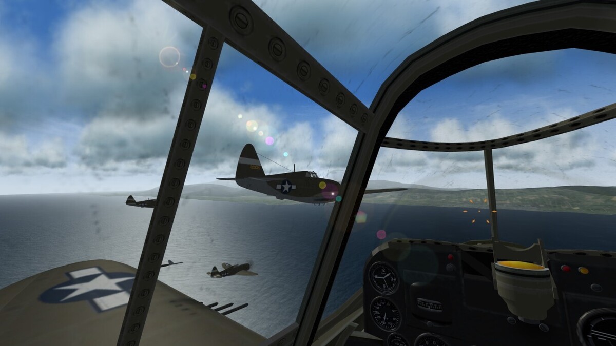
It is quite easy to set up the other wingman experience mission type which I play most in SF2, namely interception of unescorted bombers. Just make any desired tweaks to your selected planes as discussed above, and then create an interception mission in the SF2 mission editor. Edit the bomber mission to choose the number, type, airbase and target of the bombers, and then edit their waypoints to approach their target from the desired direction and height. Now edit your own flight to take off from an airbase near the target, shift your objective waypoint to match the position and height of one of the bombers' nearby inbound waypoints, and shift your track to your objective to run along the bombers' track in the reverse direction. Select the 2 coincident waypoints to find how long after take-off your flight and the bombers will reach them, and note the difference. You can now save the mission, exit the sim, and open the mission file with Notepad in order to duplicate your flight to create your wingman experience as per my guide in the previous thread. While you are doing so, adjust the bombers' relative take-off time in seconds so that they leave a minute or two earlier than the difference you noted. This should ensure that you encounter the bombers head-on as you near your objective. If all goes well, your colleagues will exhaust their ammo against the bombers, and then after some further desultory manoeuvres they will eventually settle back on track for the return to base. You may find them again by reactivating the padlock on the nearest friendly plane which you dropped in order to engage the bombers yourself. As with attacks on ground targets, you and your colleagues face a difficult choice between engaging the bombers from afar at the risk of wasting ammo, or closing in at the risk of return hits from the bomber gunners. I just played an interception mission from the Winter War in 1939-40, which I chose because Soviet bombers usually attacked unescorted and so were vulnerable to the outnumbered Finns. I closed in so that 10% of my rounds hit home, but my quarry failed to go down and my own plane suffered in return. The picture below shows my relieved return to base in the low winter sunshine, with my leader just visible on the runway as I prepared for my own landing circuit.

- 19 replies
-
- 2
-
-
- target tweaks
- wingman
- (and 1 more)
-
Real mission planners choose ingress and egress routes which avoid flak batteries as much as possible, but with wingman experience missions, deliberately placing AAA-armed ground or naval groups along the route is a quick and simple way of modelling unexpected flak or linear arrays of AAA such as the enemy front line. Check the mission file with Notepad before you fly, since the SF2 mission editor often delays the appearance of such groups or of the rest of your flight, leaving you wondering where they have gone. You may use the random factor if you wish, to create uncertainty over whether particular groups will be encountered. I just flew a desperate hit and run bombing mission with 2 other I-153s from Haapsalu as the panzers closed in, staying at low level throughout to avoid Luftwaffe interception. Our leader exploded due to 20mm flak from the German spearheads as we skirted the southern coast, and my other colleague suffered grave damage as we successfully bombed the captured Parnu airfield, but we re-crossed the line without further hits and made it back to Haapsalu, visible above my wing in the picture below. I hoped that my own undamaged plane could be fuelled up and escape along the Gulf of Finland before our own airbase too fell to the invaders...

- 19 replies
-
- 2
-
-
- target tweaks
- wingman
- (and 1 more)
-
Even with all of my colleagues out of my control, SF2 captures very well the fundamental trade-off between accuracy and vulnerability in the age of 'dumb' weapons. I have now flown several missions against or from the re-assigned Haapsalu airbase, and in every case, diving to low level for the bomb run let us hit the target runway, but at the heavy cost of one of our planes (in one case my own) being destroyed by the vicious flak despite accelerating to top speed for the attack leg. As in real life, the combat was only a fleeting part of the mission as a whole, but it was a searing and memorable experience regardless.
-
As a latecomer with no understanding of the long-standing roots of this situation, I have deliberately avoided this touchy subject. Suffice to say that we non-programmers are enormously grateful for the incredible efforts of people like yourself who have given us so much to enjoy. Combat Ace has a cornucopia of riches in its own right (including all of the terrains I have mentioned), and it gives ample resources to take advantage of any small tweaks which I have managed to discover.
- 19 replies
-
- 2
-

-
-
- target tweaks
- wingman
- (and 1 more)
-
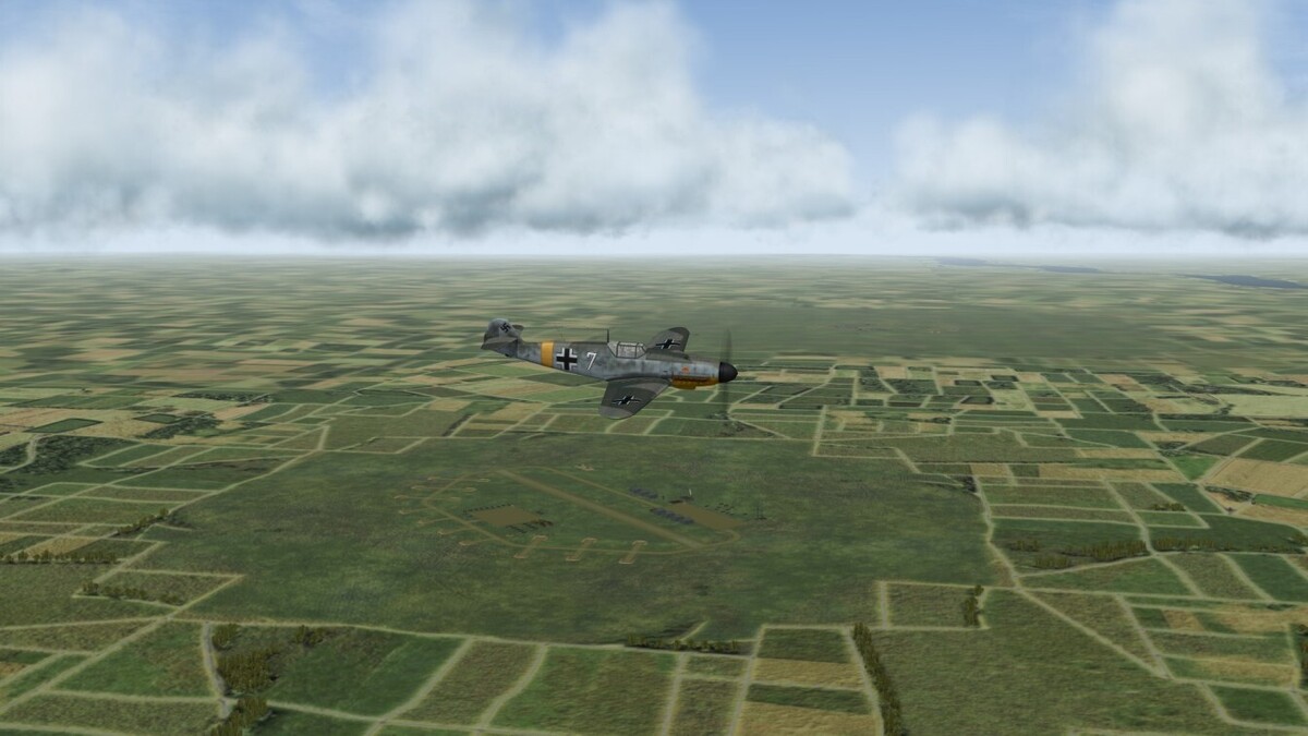
To test the flexibility of the quick and dirty modification techniques which I described above, I decided to set up a bombing raid on a Soviet airfield by a flight of Bf 110s supporting Army Group North during the early weeks of Operation Barbarossa in summer 1941. The modern Swedish terrain made by JonathanRL's TSF team gives a good coverage of the Baltic States, though it is heavily distorted at these high latitudes. To backdate it quickly to WW2, I had the bright idea of using the 'Replace All' tool when editing the sweden_targets.ini in Notepad, thereby substituting FlakAchtAchts for the SAMRadars and SAMLaunchers, and VierlingsFlak for the AAA. When I also remembered to replace these three classes in the sweden_types.ini as well as copying files into my GroundObject and Guns sub-folders if required, this wholesale substitution worked just as intended. I opted to fly from Tukums across the Gulf of Riga to bomb the Haapsalu airbase in western Estonia, before returning to land at Riga itself. All sites south of the Baltic are Enemy by default in this terrain, so I just needed to use the 'Find' tool in Notepad to locate the 3 Haapsalu entries in the targets.ini and change them to Friendly (Allied rather than Axis). As discussed above, I increased the 110's LOD ranges, cut its excessive cruising speed, and axed its fuel expenditure. It took a number of false starts to spot and correct other problems, but in the end I enjoyed an atmospheric 45 minutes of formation flying. The picture below shows us crossing the islands of Saaremaa and Muhu as we prepare to dive through the clouds and brave the flak to attack our target. The more practice one gets in tweaking SF2's wonderfully accessible files, the more satisfying the results one may achieve.

- 19 replies
-
- 1
-
-
- target tweaks
- wingman
- (and 1 more)