

Gepard
-
Content count
6,673 -
Joined
-
Last visited
-
Days Won
328
Everything posted by Gepard
-
AMX-30
Gepard replied to Steve s's topic in Thirdwire: Strike Fighters 1 Series - Mods/Skinning Discussion
I see. I have only seen pictures with a small commanders cuppola. But this was nearly 20 years ago! -
I love weapons really, but i think it is much to easy to get access to them. Why hunters or sport shooters must have their weapons at home? Why not have them stored at save places like the weapon chambers of police or army, or shooting clubs etc, but not at home.
-
Tja, wie sagt man da: "Houston wir haben ein Problem!" Mal sehen was ich machen kann. Ohne 3ds max scheint das auf den ersten blick nicht lösbar zu sein. Sch...
-
AMX-30
Gepard replied to Steve s's topic in Thirdwire: Strike Fighters 1 Series - Mods/Skinning Discussion
An AMX-30 is welcome. One of the vehicles i was trained to kill in the "good" old time. But by the way, what is this strange command turret for? I cant remember to have seen it before. -
Viewlist WIP
Gepard replied to 76.IAP-Blackbird's topic in Thirdwire: Strike Fighters 1 Series - Mods/Skinning Discussion
Yeah, looks great! -
A question to the modelling gurus
Gepard replied to Gepard's topic in Thirdwire: Strike Fighters 1 Series - Mods/Skinning Discussion
Yeah, of course. Thatswhy is my bird not an E-8, but the fictive E-9 MiG-23F/PF/PFM. A family of birds that could have been the successor of the E-8 after the canceling of E-8 program. A step back with MiG-21 engines R-11, R-13 and R-25 but proven E-8 technology. I still would love to fly the original, real E-8. Its one of my favorites! -
Ich habe noch ein kleines dummes Problem. Wenn das Flugzeug zerstört wird, von einer Rakete oder Kanone, dann wird es ganz einfach unsichtbar antatt wie es sich gehört mit einem Feuerschweif abzustürzen. Der Feuerschweif oder Rauch folgt aber dem Weg des Absturzes, nur das flugzeug ist weg. Wenn ich dann noch Tanks oder Raketen an Bord habe, dann verbleiben diese an ihren vorherigen Positionen während das Flugzeug vom Bildschirm verschwindet. Hattet ihr dieses Problem auch schon einmal?
-
Hat geklappt. Danke nochmals. Auch vielen Dank von den Maulwürfen, die nun viel ruhiger leben.
-
A question to the modelling gurus
Gepard replied to Gepard's topic in Thirdwire: Strike Fighters 1 Series - Mods/Skinning Discussion
The problem with the flat tire is solved. It was one of the last things i was able to do before my 30 days trail version of 3ds max were over. So i will release this bird after flight testing as "unfinished". If someone want to take over then, no problem with it. And to the NATO Code "Fishtail", why not, sound a little bit like Mermaid. Perhaps with a little nice pin up girl as decale. -
Danke, werde es versuchen.
-
Habe ein kleines Problem mit dem FM. In der Luft ist die 23PFM ein wahrer Schatz, nur beim Start hat der Autopilot mitunter ein Problem. Manchmal knallt das Heck auf die Startbahn, dann gibts ein Feuerchen und dann macht es BUMM. Aber eben nur manchmal. Bei den KI gesteuerten Flugzeugen passiert das nicht. Hat jemand eine Idee was ich machen könnte?
-
Indian Air Force retires MiG-23BN "Vijay"
Gepard replied to ghostrider883's topic in Military and General Aviation
I always thought the MRCA program was set up to replace the 23BN? -
Fragt sich welche 29UB NVA skin. Da gab es die im sowjetischen Stil und die in NVA Tarnscheck.
-
A question to the modelling gurus
Gepard replied to Gepard's topic in Thirdwire: Strike Fighters 1 Series - Mods/Skinning Discussion
Frodo? Sounds not bad, but was "Lord of the Rings" already known in the 60th? I will check it. And the other idea with fish- at the beginning, is also not bad. I'll see. The only thing i have still to do is to make a template for a better skinning. And then ... will see how the flight tests perform. -
A question to the modelling gurus
Gepard replied to Gepard's topic in Thirdwire: Strike Fighters 1 Series - Mods/Skinning Discussion
I think i got it! Perhaps not perfect, but i'm satisfied for the moment. I believe this new MiG-23PFM would need a new NATO designation. Any suggestions? -
Yak-38 Forger
Gepard replied to mono27's topic in Thirdwire: Strike Fighters 1 Series - Mods/Skinning Discussion
looks great! -
A question to the modelling gurus
Gepard replied to Gepard's topic in Thirdwire: Strike Fighters 1 Series - Mods/Skinning Discussion
Thanks. Will give it a try. -
A question to the modelling gurus
Gepard replied to Gepard's topic in Thirdwire: Strike Fighters 1 Series - Mods/Skinning Discussion
Erik, Blackbird, thanx a lot. Now it runs as it should. If i now only could make the nosegear steering then i would be happy. -
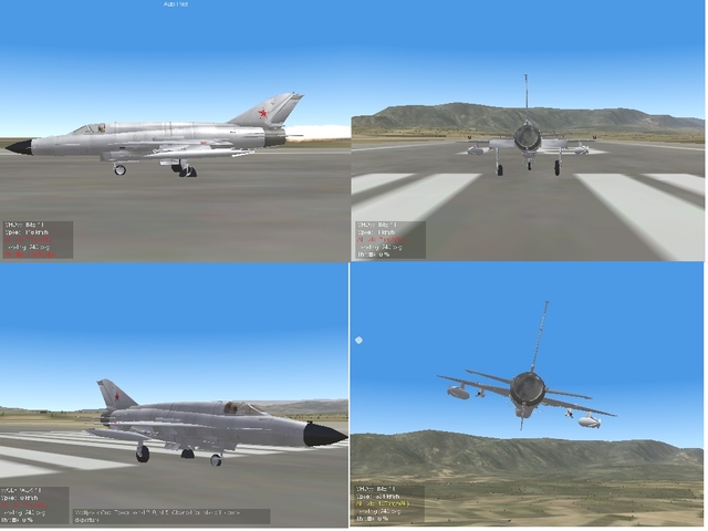
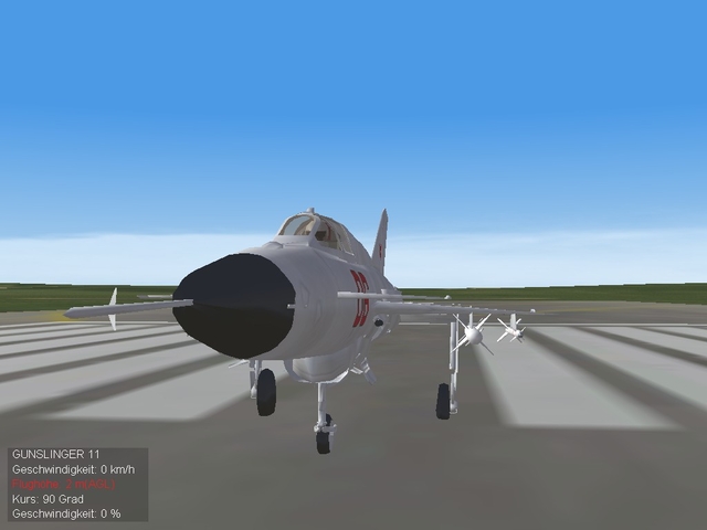
A question to the modelling gurus
Gepard replied to Gepard's topic in Thirdwire: Strike Fighters 1 Series - Mods/Skinning Discussion
I hope this pictures will help. I must go now to work. In 8hours i will be back. -
-
A question to the modelling gurus
Gepard replied to Gepard's topic in Thirdwire: Strike Fighters 1 Series - Mods/Skinning Discussion
No. unfortunatly not. Could it have something to do with the LOD file? -
A question to the modelling gurus
Gepard replied to Gepard's topic in Thirdwire: Strike Fighters 1 Series - Mods/Skinning Discussion
In the air all is symmetrical. The entries are also the same in the Data.ini -
A new MiG detected at soviet airfields in EastGermany
Gepard posted a gallery image in Strike Fighters: Project 1
-
American planes sniffing along russian borders, why should not the russians do the same with north american airspace? If you like the one side of the medal, you must love the other one!
-
Nothing new with the russian behaviour. They make with others, what others make with them. Dont worry about that.