
Menrva
-
Content count
4,443 -
Joined
-
Last visited
-
Days Won
45
Everything posted by Menrva
-

Hey, Stary...Could You Do Us a Favor?
Menrva replied to PFunk's topic in Thirdwire: Strike Fighters 2 Series - Mods & Skinning Discussion
PFunk, do you have a older version of the heightmap, one that was not resized? The heightmap should be modded and flattened only at the end, if you work on it more and more time, it gets broken and less detailed. If you wish I can provide help, just send me a PM, and I'll show you my way to resize and make 250m heightmaps (without using .act palettes and other "unuseful" stuff). I can also make a brand new heightmap that matches your exact area, so that you won't need to replace targets locations or retile it, etc. (see what I've done for FRPignon's Europe terrain). I noticed that you flattened lakes with height=0, as if they were sea. It's better to flatten lakes and rivers, etc. as if they were part of land, the same thing we do with airbases flattening. IMHO it's not worth inverting the colours of the palette at this time, but it can be done easily; it's better to work with a heightmap bitmap exported with TFDtool (the one that is black and white) instead of the ones you have showed before. Open with Photoshop, simply invert colours. Now, sea areas will be white instead of black, so next step would be to export (always with TFDtool) a tilemap bitmap. From it, select by colour (there is a tool in each paint program for this) the sea areas. Copy and paste them over the heightmap, and turn them completely black. Some small tweaks here and there, and it's done. Believe me, once you understand how it works, it's a five minutes job. Ah, even if the bitmap is black and white, just save it as a 8bit bitmap, and you can import it into TW's TerrainEditor. This is also what Stary explained in his tutorial for 250m heightmaps. I no longer see the utility of working with .act palettes, now that we can use both TFDtool and the TE together. Again, heightmaps should be the last thing to mod, it's better to place targets and tiles first, flattening is the last thing to do (I suggest using gerwin's TFDtool, for all kinds of flattening, lakes, rivers, airbases). So, if possible, I suggest reverting to a precedent heightmap if you have it, even a 500m one. It can be easily converted into a 250m at the end. -
What a beautiful, moving thing, my best wishes to this guy and the organization! Having suffered from bullying and (subsequent) depression, I know how difficult it is for someone to recover. I once thought there was no one that cared about me, and that was a big mistake. There were loved ones I didn't notice or forgot about. I wish there were organizations like this in my country, today's threat is cyber-bullying as well.
-
In-flight chat text colours
Menrva posted a topic in Thirdwire: Strike Fighters 2 Series - Mods & Skinning Discussion
I'm making some interesting changes to the game's default HUD, eventually I will release my modded .ini files in a simple package. I have a problem regarding text colours: As you can see in the image above, text from other pilots is dark blue, yet I'd like to change the colour from dark blue to the light blue you can see in the box at the lower right-end corner of the image. I can't seem to find the related parameter in any of the .ini files, it's like it is hardcoded. Can anyone confirm this? -
Difference between Red Crown and Hawkeye?
Menrva replied to Stratos's topic in Thirdwire: Strike Fighters 2 Series - General Discussion
The avionics .dll has only to do with the aircraft avionics, it has nothing to do with speechpacks. It's the NATIONS.ini in the Flight folder that controls which speechpack is activated, according to the chosen "nation". IIRC Hawkeye appears by default when flying for USN and USMC, that's it. Not to mention how bad and incomplete Hawkeye's speech is, the fact that other flights still call for Red Crown instead of Hawkeye, etc. Red Crown is historically accurate for the Vietnam era, AFAIK. I miss the AWACS voices from Jane's USAF, they were cool and rather professional. -
In-flight chat text colours
Menrva replied to Menrva's topic in Thirdwire: Strike Fighters 2 Series - Mods & Skinning Discussion
I too have found lots of unused parameters inside the dlls, through an Hex editor. From what I've seen most if not all of the unused stuff doesn't work. Keep us informed with any findings, EMCON360. Maybe there is something working in the code. -
In-flight chat text colours
Menrva replied to Menrva's topic in Thirdwire: Strike Fighters 2 Series - Mods & Skinning Discussion
Thanks for the reply, EMCON360. Unfortunately it's not what I was looking for. The parameters you posted are relative to the comms box, the one we use to communicate orders to flights and to ask the TACC for help. From what I have seen, it's all hardcoded, there is no way to change colour to the flights subtitles. That blue is too dark for my likings. Yellow and red are still visible under various conditions, those are ok. -
Hey, Stary...Could You Do Us a Favor?
Menrva replied to PFunk's topic in Thirdwire: Strike Fighters 2 Series - Mods & Skinning Discussion
FRPignon, did you flatten airbases with TW's TerrainEditor function? Such oddities are caused by it. That's why I resorted to use gerwin's mighty TFDtool for almost everything; with it you can tweak the heights of single tiles, and you can create small, simple flat tiles unlike TW's big circular ones. -
Hey, Stary...Could You Do Us a Favor?
Menrva replied to PFunk's topic in Thirdwire: Strike Fighters 2 Series - Mods & Skinning Discussion
I'd say not. A screenshot would help better. -
Hey, Stary...Could You Do Us a Favor?
Menrva replied to PFunk's topic in Thirdwire: Strike Fighters 2 Series - Mods & Skinning Discussion
I should have wrote it earlier, I followed pretty much everything that you said, Stary. However, in regards to sea areas, I usually take them from the texture bitmap, and copy them into the heightmap bitmap, and paint them completely black, so that when I reimport them into the TerrainEditor, sea is blue (IIRC your Kamchatka HFD treats sea as land, but only in regards to altitudes of course, it doesn't affect gameplay in anyway). Also, I rather use gerwin's TFDtool to flatten rivers, airfields and lakes, and I usually tweak the exported bitmap to add slight blur between the flat tiles and the surrounding, non-flat ones. Just minor tweaks. I would avoid using the smooth heightfield function of the TerrainEditor, since it really removes many details of the heightmap. What I learned is, the less you touch a heightmap, the better, unless it's necessary for water bodies and airbases. -
Baltika's Georgia Terrain?
Menrva replied to Spudknocker's topic in Thirdwire: Strike Fighters 2 Series - Mission & Campaign Building Discussion
Good to hear from you, Baltika! I've experimented with 250m heightmap, and the results are really great. I know it's difficult to work on terrains due to RL and overambition; the Iran/Iraq terrain I released was my first effort, and it did take three or more years of development, mostly because I was never happy with it... -
Hey, Stary...Could You Do Us a Favor?
Menrva replied to PFunk's topic in Thirdwire: Strike Fighters 2 Series - Mods & Skinning Discussion
PFunk, if you want I can help with 250m heightmaps, I "developed" a similar procedure to the one discovered by Stary. Also, it's not too late for your Aegean terrain, I can convert it to 250m resolution. I already did it for my Iran/Iraq terrain, and for the Europe terrain FRPignon is working on. I am also planning a series of mods that will include 250m height maps compatible with SF's stock and custom terrains. Now I'm not at home, but feel free to send me a PM if you're interested, and as soon as possible I will reply and fill you in with a step by step procedure. -
1st Look: Aegean Sea v0.2b & HAF Su-30MKG Flanker
Menrva replied to PFunk's topic in Thirdwire: Strike Fighters 2 Series - Mods & Skinning Discussion
Wow, it's beautiful, PFunk! I always desired a smaller version of the Anatolia terrain, and here you made it! -
Another Terrain Problem...
Menrva replied to PFunk's topic in Thirdwire: Strike Fighters 2 Series - General Discussion
Simply you can't. I'm afraid that you'll have to scrap those two airbases. If people own SF2NA, you can make such airbases as OffMapAirbase=TRUE (just check he stock IcelandNA terrain's targets.ini). Or try to make a bigger terrain, 2000x2000, but that means you'll have to start from the beginning. I think first choice is the one you may want to do. -
 It's not my fault, it's a bug introduced in SF2NA. Nobody knows how to fix it atm.
 -
In-flight chat text colours
Menrva replied to Menrva's topic in Thirdwire: Strike Fighters 2 Series - Mods & Skinning Discussion
yubba, it works in SF2, but it's not what I asked about. Please do not hijack the thread. -
In-flight chat text colours
Menrva replied to Menrva's topic in Thirdwire: Strike Fighters 2 Series - Mods & Skinning Discussion
Unfortunately no, it has nothing to do with that .ini. Logic says such parameter should be in the hud.ini, but I can only find the following that apply to in-flight dialog: NormalColor=1.0,1.0,1.0,1.0 (white for common messages) WarningColor1=1.0,1.0,0.0,1.0 (yellow for warnings towards your flight) WarningColor2=1.0,0.0,0.0,1.0 (red for warnings towards your aircraft) I know this already, yubba, I made several changes to target boxes. You can change the color with the following parameter: BoxColor=1.0,1.0,1.0,0.75 First three numbers are RGB (Red-Green-Blue) colours, fourth value is transparency. 1.0 is equivalent to 255 in programs like Paint. Choose a colour in some painting software. Let's say that your custom colour has a Red value of 223, you simply divide 223 by 255, and you have the value to put in the BoxColor parameter. I hope this is useful to you. Back to topic, I think I'll give up, it really seems it is hardcoded, I have looked everywhere. Damned TK always locking things up! -
CTD - Ground Map Mode on Multiple Aircraft
Menrva replied to TheStig's topic in Thirdwire: Strike Fighters 2 Series - Mods & Skinning Discussion
Among the things that Ground Map mode uses are the _HM.bmp files; I have reason to believe that they are the behind the CTDs. Just thinking out loud. -
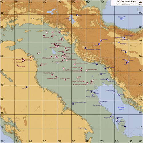
Iraq, Western Asia (1980-2003)
Menrva replied to Menrva's topic in Thirdwire: Strike Fighters 2 Series - File Announcements
Thanks for the kind words. I'm glad that the bug you experienced with the early version of the terrain is no longer present. Trees have been removed from certain tiles, since there are rough mountains, and they would look bad. I hope that in the future some artists manage to make a whole new tileset for it, with better TODs. BTW, with little modding knowledge this terrain can be made to work with Spudknocker's campaigns, since this one is also a better-looking version with the plus that Iran's got new SAM sites which were totally missing from the early version. -
Sure thing. I noticed that the India-Pak terrain suffers from similar mistakes too. The Pakistani capital is a bit off in its current location, etc., but IIRC targets are not so off from their Real World locations. The terrain I made seriously needed a facelift in this regard, so I'm happy to hear that you guys like it. It took me a lot of free time, effort, blood, sweat and tears, just to make it closer to the Real World.
- 12 comments
-
- 1
-

-
- iraqi freedom
- iraq
- (and 8 more)
-
Thirdwire terrain editor palette
Menrva replied to Peugeot205's topic in Thirdwire: Strike Fighters 2 Series - Mods & Skinning Discussion
EDIT: ops, sorry, my bad, you were asking about the tile map import, which I never tried. I hope you find the following about height map bitmap import useful, anyway. Check the following statements inside the TerrainEditor.ini [bitmapImport] HeightScale=22 MinLandHeight=0 HeightScale makes a huge difference. I had to set it at 22, otherwise my Iraq terrain would have had wrong altitudes for mountains etc. Each terrain has its perfect value. So I suggest that you check the original EAW map in TFDtool, there you can see the heightmap value of each tile. Focus on the one who is more red (the higher altitude). Import the bitmap in the TerrainEditor and check with TFDtool. If you get similar altitudes it's okay, if the altitudes you get are lower, you should increase the HeightScale value and reimport the bitmap again and recheck with TFDtool. It's time consuming, but worth it. Oh, BTW, you can also take real height values for reference. For instance, you can use Google Earth to get the values of altitudes you might want. Sometimes, you get an already "wrong" HFD to work with, meaning that altitudes are wrong, mountains are flat after certain values, etc.. The less you mod the HFD, the better, because reworking an HFD too many times might get to the point that the terrain won't be realistic. Another big suggestion, do not import and then export the same bitmap multiple times, because each time it loses quality and detail. Make your own bitmap file, and when you think it's okay, just focus on the HeightScale value in the TerrainEditor.ini. -
GermanyCE missing SAM sites - BUG - Important!
Menrva replied to Snailman's topic in Thirdwire: Strike Fighters 2 Series - General Discussion
Jackpot! What can I say, you discovered a bug that is present on almost all terrains. I have a very huge mod folder with many terrains. Same ActiveYear setting of 1965. It's totally pointless that it is present. Even ActiveYear=0 should do, as long as SAM objects have their own Service Year statements correctly added. -
Iran-Iraq war
Menrva replied to Centurion-1's topic in Thirdwire: Strike Fighters 2 Series - Mission & Campaign Building Discussion
Standalone terrain package has been uploaded, waiting for admin approval... Unlike the one included in Spudknocker's Iran-Iraq war mod package, this terrain has additional features and eye-candy stuff. You can use the newest release in place of the old one in said mod package, as long as you mod campaign files to fit the new naming conventions of the terrain itself and some of its targets. -
I usually hate things that become viral over the internet; however, there is a new series of funny videos on YouTube; countries try to promote themselves to Trump's America, to gain second place in the standings. Here I begin with my country:
-
 Great work, Snailman! I like such attention to details!