-
Content count
4,469 -
Joined
-
Last visited
-
Days Won
46
Content Type
Profiles
Forums
Calendar
Gallery
Downloads
Store
Everything posted by Menrva
-
- 9 comments
-
- persian gulf
- iraq
-
(and 2 more)
Tagged with:
-
- 9 comments
-
- persian gulf
- iraq
-
(and 2 more)
Tagged with:
-

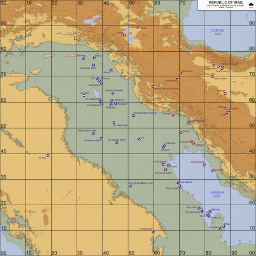
Iraq, Western Asia (1980-2003)
Menrva replied to Menrva's topic in Thirdwire: Strike Fighters 2 Series - File Announcements
Terrain package updated to Version 1.02. Major changes and bug-fixing, it's well worth re-downloading this time.- 25 replies
-
- 2
-

-

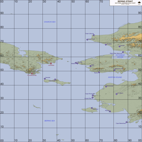
Alaska, Bering Strait (1955-2018)
Menrva replied to Menrva's topic in Thirdwire: Strike Fighters 2 Series - File Announcements
Terrain package updated to Version 1.01, various fixes and tweaks. -
CSS, right? CombatACE's UI is fine, simple and intuitive!
-

Mirage F-1C-200
Menrva replied to ludo.m54's topic in Thirdwire: Strike Fighters 2 Series - Mods & Skinning Discussion
It's the same I have in the terrain, I didn't notice the AA guns. Well, now they are targetable as it was suggested. Expect a release shortly. To Crusader & Team, sorry for the little thread hijack. -

Mirage F-1C-200
Menrva replied to ludo.m54's topic in Thirdwire: Strike Fighters 2 Series - Mods & Skinning Discussion
We really need an updated ODS campaign with my terrain and the new aircraft models. It's been a while since eburger68 last appeared. I hope he is okay! In my terrain there are oil platforms, but they are not targetable, I did it so because I don't think it would be compliant with ROEs. It's just a matter of seconds to make them as targets though. There are oil terminals and oil fields as targets, instead. -

.INI entries priority?
Menrva replied to swambast's topic in Thirdwire: Strike Fighters 2 Series - Mods & Skinning Discussion
I'd say the _types.ini has priority. The object's separate .ini file comes into play when that object is not used inside the _targets.ini, but it's randomly generated in single missions. -

Changing Airbase Alignment by Year
Menrva replied to ragnarokryan's topic in Thirdwire: Strike Fighters 2 Series - Mission & Campaign Building Discussion
It's doable, I've done something similar in my Iran/Iraq terrain. Basically, you create two targets. One which gets deactivated after a certain date with the InactiveDate statement. The other target, with different alignment, only shows up after a certain date, with the ActiveDate statement. You also have ActiveYear, but that one is more generic, you can only specify the year, while with ActiveDate you can define Month/Day/Year. -
I remember him on a number of great movies, from The Right Stuff to Black Hawk Down. Rest In Peace.
-

Mirage F-1C-200
Menrva replied to ludo.m54's topic in Thirdwire: Strike Fighters 2 Series - Mods & Skinning Discussion
I'll wait until Crusader feels like they're ready for release. A major update of my Iran/Iraq terrain is inbound next month, together with a post 2003 version. Perfect playground for them. -

Not too familiar with this stuff
Menrva replied to Heck's topic in Thirdwire: Strike Fighters 2 Series - Mission & Campaign Building Discussion
Oh, pardon me, Heck, actually I still need to check. I am on the very last patch. It could have been fixed in the later patches, who knows? Much has changed since the 2012 level patches. I'd like to hear from others as well. Are you running a modded install or simply stock? -

Not too familiar with this stuff
Menrva replied to Heck's topic in Thirdwire: Strike Fighters 2 Series - Mission & Campaign Building Discussion
Really? How come I didn't notice this earlier? It's been a while since I last played a campaign. Seems a bug to me, maybe introduced with the latest patches. -
Cool photos! Link does not work on my end, it returns the dreaded 404 error. Anyone can confirm?
-
Another article at BBC, in English of course: http://www.bbc.com/news/world-asia-china-40578106
-

Balkans terrain
Menrva replied to ignacioc91's topic in Thirdwire: Strike Fighters 2 Series - Mods & Skinning Discussion
Me neither, I have no access to the modders' repository. Which are the requisites? Anyway, I don't think Baltika's WIP is there. We would need his explicit consent to proceed upon his work, too. -

CP-140 Aurora
Menrva replied to 1977Frenchie's topic in Thirdwire: Strike Fighters 2 Series - File Announcements
Great skins! Thanks for sharing, 1977Frenchie! I was wondering, when was the low-viz scheme introduced exactly? I was looking for info, the best I found was that the change between hi-viz and low-viz happened during the 80s. -

Balkans terrain
Menrva replied to ignacioc91's topic in Thirdwire: Strike Fighters 2 Series - Mods & Skinning Discussion
Being Italian, I would like to help on any WIPs of the Balkan theater. In the past, some tried to recreate such terrain, but were limited by the tools available at the time (working on heightmaps was a nightmare). Today, we have more powerful tools, new techniques (Stary's discovery of 250m heightmaps comes to my mind) and so on. The most advanced WIP I recall is Baltika's. I am wondering if there are others as well. -
Very sorry to hear this. I upgraded to the latest build voluntarily and I didn't have any major issues (except one which broke mostly all Adobe Photoshop products, and neither companies are willing to solve the matter). It's very strange that you cannot go back to the previous build. Usually, after such big updates, there is always a Windows.old folder which contains everything needed for a full restore to the previous build. I really don't know what might have happened.
-
What the topic title says: http://www.bbc.com/news/av/uk-40426747/luftwaffe-ace-flies-in-spitfire
- 1 reply
-
- 2
-

-

The new HMS Queen Elizabeth!
Menrva replied to Wilches's topic in Thirdwire: Strike Fighters 2 Series - General Discussion
Landing a F-35B on the HMS Queen Elizabeth, using a multi-room flight simulator: http://www.bbc.com/news/av/uk-40405476/hms-queen-elizabeth-how-to-land-a-plane-on-new-ship -

Ace Combat 7 Skies Unknown - E3 2017 Trailer
Menrva replied to Menrva's topic in General Flight Sim Discussion
Yep, they are using the Unreal Engine 4, it was about time they decided to make a PC release too. For all of you who are interested, here are two gameplay demos, the first with commentary from the AC director himself, Kazutoki Kono. For the second video, keep in mind that the dubbing is still a work in progress, I think; there are some translation mistakes (noticeable also in the E3 trailer). -

Super Hornet shoots down Syrian Su-22
Menrva replied to MigBuster's topic in Military and General Aviation
Little sh*t hit the fan; Russia has confirmed that it will view US-led coalition aircraft as targets, from now on: http://www.bbc.com/news/world-middle-east-40329036 Another article regarding today's rarity of air-to-air kills: http://www.bbc.com/news/world-40327934 -
- 4 comments
-
- bering strait
- dbs
-
(and 3 more)
Tagged with:
-

Sukhois
Menrva replied to 76.IAP-Blackbird's topic in Thirdwire: Strike Fighters 2 Series - Mods & Skinning Discussion
Ditto that. Wish you and your family the best, 76.IAP-Blackbird.- 471 replies
-
- sf2 fitter
- su-17m fitter
-
(and 3 more)
Tagged with:


