


About This File
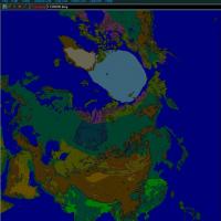
This is a prototype 12,000km tiled, but not textured, map called Baikal, for summer season. The downloaded file is Baikal.7z. Unzip it with 7zip into a new folder not in the game folder. Copy the unzipped Baikal folder into the Terrain folder. The 99MB download is mostly very large bmp files used for development.
I am using SF-1, patched to October 2008.
The files in the Baikal folder are alphabetically ordered. This is essential for easy viewing of the folder contents. Folder set to view "list" helps me see the whole folder in one screen.
Tiles are 3km on a side, which is a minimum for this size map. There are no "real" textures for the prototype map.
I can't texture. I tried, but...
Only blank colour coded tiles are here, for tile mapping development, and blank tiles allow easy viewing in Terrain Editor zoomed out view. This terrain is made for paleo-antiquity classical high altitude strategic operations, and terrain variation is over a vastly greater scale than normal SF maps -- which means less detail seen from the cockpit at normal low altitude SF gaming, unless one expands their horizon distance to see more of less. The good news is that 3km tiles allows a modest 1.5x increase in framerate or 1.5x increase in HorizonDistance over the SF standard 2km tile sizes. I am currently running 200km horizon distance with ATI 4850 video card, and other game tweaks.
Much more info is in the readme file called " = 12m3 notes " . Also, the Viewlist readme is useful for exploring the map quickly.
No tile was left behind.
-
 1
1
Recommended Comments
Create an account or sign in to comment
You need to be a member in order to leave a comment
Create an account
Sign up for a new account in our community. It's easy!
Register a new accountSign in
Already have an account? Sign in here.
Sign In Now