

chrispdm1
-
Posts
99 -
Joined
-
Last visited
Content Type
Profiles
Forums
Gallery
Downloads
Store
Everything posted by chrispdm1
-
WOFF Westen Front Airfield Maps
chrispdm1 reviewed chrispdm1's file in Maps, Missions, and Campaigns
-
View File WOFF Westen Front Airfield Maps This is the second version of my airfield mapping for Wings: Over Flanders Fields. Credit goes to Rabu for his Flanders map that he has allowed me to use to map airfields on. The Paris map was created entirely by myself. The others were public domain and the airfield data came from WOFF itself. Please do not repost or change and distribute without crediting rabu and myself. Submitter chrispdm1 Submitted 12/21/2013 Category Maps, Missions, and Campaigns
-
Version 1.1
183 downloads
This is the second version of my airfield mapping for Wings: Over Flanders Fields. Credit goes to Rabu for his Flanders map that he has allowed me to use to map airfields on. The Paris map was created entirely by myself. The others were public domain and the airfield data came from WOFF itself. Please do not repost or change and distribute without crediting rabu and myself. -
WOFF Default Keyboard Controls View File Here is a quick sheet I compiled showing all the default keyboard and joystick controls in Wings: Over Flanders Fields Submitter chrispdm1 Submitted 12/12/2013 Category Maps, Missions, and Campaigns
-
-
My keeps syncing every pilot to March 11, 1917. I've tried deleting every pilot and starting a new one earlier, but nothing keeps it from syncing to that date.
-
go to the downloads section and you can find them there under the maps section. You can download them from there and they should be downloaded as a zip. Extract them and they should be able to be printed out as an image file. Let me know if you have troubles
-
yep, Phase 3, just version 1.0, you can find the patches on the OFF site to get it up to speed....
-
What I'd like to see in Phase IV
chrispdm1 replied to BigAl56's topic in WOFF UE/PE - General Discussion
I would love to see everything kinda rounded out on the Western front before turning towards the Alps..... Belgians would be nice!! fly around some Hanriots with Coppens... throwing in a couple of early 2 seaters for all nations -
I got to my second post.... not kidding. I just about gave it up here, but I realized he is only one person and not representative of everyone on the forum.
-
Poll: How good is your hit accuracy?
chrispdm1 replied to vonOben's topic in WOFF UE/PE - General Discussion
I've always shot right around 23-24% pretty consistently. -
How about damage from the observer guns on your own machine, ala IL2... I'm sick of getting shot down by observers shooting through their planes surfaces ie... front wings, etc. I suppose the ai would continue to do so with damage though, wouldn't they? they would hav eto be coded to stop shooting when damge is inflicted on their own plane? just a thought
-
Flying By Map And Compass, Part Deux
chrispdm1 replied to RAF_Louvert's topic in WOFF UE/PE - General Discussion
yep, the small towns are impossible to fly by as there are clusters of houses all over the map!! but the bigger ones are easy enough to see.... Ypres being one of them. Ypres and Verdun are the only ones I have run across where they are improperly placed by MCFS3. The others seem to be fine, not that I have done tons of flying with these things though... -
Flying By Map And Compass, Part Deux
chrispdm1 replied to RAF_Louvert's topic in WOFF UE/PE - General Discussion
And if your using that map... do not use Ypres to navigate by.... :P its way out of wack in the game.... same as Verdun... The only other thing to add is make sure you get it right with miles and kilometers. It's been a while since I've flown by map, but I remember running into that issue - something like it says in game that its miles but is actually listing km or vice versa. I don't know if that was fixed or not, that was a while back. -
View File Flanders maps rev. Here are the Flanders amps with the aerodrome names right on the map. The sidebar is irrelevant material right now. Submitter chrispdm1 Submitted 03/03/2010 Category Maps, Missions, and Campaigns
-
they are uploaded now.
-

112 downloads
Here are the Flanders amps with the aerodrome names right on the map. The sidebar is irrelevant material right now. -
I'm just putting more visible roundels on right now, when I get back home tonight after work I will get them uploaded.
-
I've already got the Flanders maps with the airfield names on them. I did it in preperation of having a complete crossreferenceable map system. I could upload them now if you'd like, I still have to put cross section reference points on them though. They have the names on the map instead of being in a white tag. I also took some needless info out, like multiple aerodrome locations on the map that are slightly off of where they are in the game.
-
Hey, FYI, I just completed my map for the Meuse-Argonne region. It is in the download section.http://forum.combatace.com/index.php?app=downloads&showfile=10634 Yeah, I have just been using google and some good old cartographing to get these maps in shape. I got away from it for a while, but finished this one up on the weekend. I'd still like to come up with a good Alsace map showing roads, railroads, rivers and towns. There is a pile of data to use on these sorts of projects!! Olpaint's spreadsheets attests to that! I attempted to make a map for use in place of the in game flight map, but I'm afraid it is a lost cause. Due to projection limits and possible inaccuracies, you could never find something that would match up with the actual environment of CFS3. The simple green map is 3 mb in size and if you started getting detail into there, it would rocket in size and slow the game down exponentially especially when using the map. I would like to over the next couple months come up with a complete maps package with an index and of course maps of other areas as well, but we'll see what happens. Thanks for the kind words!
-
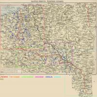
View File Meuse-Argonne Aerodrome map Here is a map for the Verdun/Meuse-Argonne region with aerodromes marked Submitter chrispdm1 Submitted 02/28/2010 Category Maps, Missions, and Campaigns
-
New map: Meuse Argonne http://forum.combatace.com/index.php?app=downloads&showfile=10634
-

78 downloads
Here is a map for the Verdun/Meuse-Argonne region with aerodromes marked -
How do I make custom skins for my ace in HIR
chrispdm1 replied to appraiserfl's topic in WOFF UE/PE - General Discussion
what they said.... but posting the same question 4 times isn't going to get you a different answer.... patience my friend...
