

Lexx_Luthor
-
Posts
3,352 -
Joined
-
Last visited
Content Type
Profiles
Forums
Gallery
Downloads
Store
Everything posted by Lexx_Luthor
-
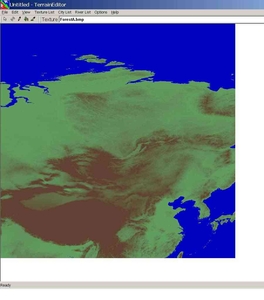
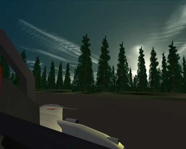
From the album: Siberian Sky
China, India, and Siberia at 4000 "SF" kilometers -- actual near 6500km. Tile resolution 5000km, far too large so the map fits into the monitor screen. -
Wow, thanks Trooper. The radar control panels might be rotated so as to hide the switches and knobs. To see the wing nicely, I use cockpit Position as follows...the Offset I'm experimenting with regarding the pipper. [CockpitSeat001] ModelName=Su7_Cockpit Offset=0.0,0.12,-0.085 Position=0,1.50,1.00
-
B-36 B-45 B-70 F-101 F-99 (Bomarc SAM) C-119 C-124 SR-71 Tu-128 Yak-19 (original, 1946) Su-17 early, 1967, small spine Genetrix, for some Cold War balloon busting. S-25 SAM AJAX Shucks...throw in a B-51.
-
Fresco --> MiG-17P, PF, and PFU. Single seat, single engine, single radar.
-
Real forrests for WoE Nato2 development pics
Lexx_Luthor replied to Stary's topic in Mods/Skinning Discussion
Okay, I make my own AIRFIELDn.ini and make it blank...no text...no reference to any LODs. Then, I setup the airfield data like takeoff positions and runway lights in the airfieldN data file, but I've not done it here yet as seen below. I've turned a bit to see the wingman, and he's just beyond the airfield tile (positions made for runway LOD). On the 50-50 transition tile, I've left a clear spot in the trees at both ends to represent clear cutting, but not grading and surfacing, to clear space for takeoffs and landings. I might cut Stary's trees down -- setup the Min/Max Y values to include only the bottom tree trunks. That would be pretty neat. Wingman taking off ahead of me. The terrain is flattened in the TE, otherwise the AI would have a problem bouncing all over the place. -
From the album: Siberian Sky
-
From the album: Siberian Sky
-
Aussum! Thanks ya'll.
-
Real forrests for WoE Nato2 development pics
Lexx_Luthor replied to Stary's topic in Mods/Skinning Discussion
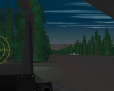
Letting AI take off Pasko's Yak-25 for me, while I enjoy looking out the window. I've brightened the tree colours, to better match terrain tile color. Matching tree and average tile colour helps reduce the distraction of the sudden pop-up and, in my case, greatly reduces the flashing trees from high altitude I see when I need NearClipDistance less than 0.2 when using a small "stargetic" cockpit panel + external model that requires such a low value (above 0.2 and no flashing). -
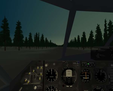
From the album: Siberian Sky
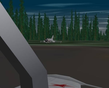
Takeoff from experimental primitive runway. -
Real forrests for WoE Nato2 development pics
Lexx_Luthor replied to Stary's topic in Mods/Skinning Discussion
Sokol, check in your TE folder for the new saved files. Copy them to the terrain folder. You can customize the folders TE uses in the TE ini file. TE can read or imports files, and then save or export new file, to and from more than one place. -
Real forrests for WoE Nato2 development pics
Lexx_Luthor replied to Stary's topic in Mods/Skinning Discussion
Wow, thanks VELTRO. I can do MUCH better, at higher res too. :yes: Stary, I'm using flattened airfield terrain, just no LOD. I intend to make an invisible collision "wall," matching the treeline or runway edge. What's scary is approach and the treeline in front of the runway. This is no "Super Airbase." -
Real forrests for WoE Nato2 development pics
Lexx_Luthor replied to Stary's topic in Mods/Skinning Discussion
Ah, this is it! Stary, I'm using your enlarged NINE PINE here. I use 200 for the airfield tile, and 50 for general forest tiles, and fewer for less dense forest tiles and transition tiles. The larger tga gives good forest for less number of objects. Pasko's Yak-25 on primitive runway that is painted on the terrain tile. No airfield LOD. I eventually plan to create invisible collision objects that border the runway on all sides except for a taxiway, and match the collision box with tree height. This should make things very interesting. About the MipMap thing...the trees looking odd. I think cutting out the tree trunks helps some. Reduce the Max Y value to cut out the trunks. That's what I did here. -
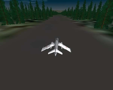
From the album: Siberian Sky
-
From the album: Siberian Sky
-
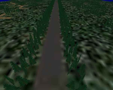
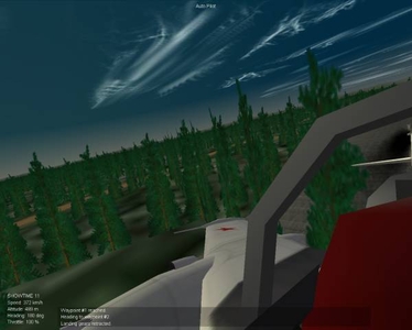
From the album: Siberian Sky
First step: 3-Pines tga's, by CA_Stary, bounding runway. -
From: Actual Air to Air Refuelling in YAP 2?
Lexx_Luthor replied to MigBuster's topic in General Discussion
Low thrust modifiers in the Mach table would result in low fuel consumption? What about...for a second engine, the WetMachTableData could be made to have Zero values except at one specified re-fueling altitude, thus the extra engine uses no fuel except in that narrow altitude range -- some altitude not commonly flown normally, an altitude where the AI "tanker" aircraft would be set to fly. That would force you to fly to and stay in that altitude band until refuel is complete. I guess anyways. like this... WetMachTableNumData=4 WetMachTableDeltaX=0.1 WetMachTableStartX=7.0 WetMachTableData=0,0,-5.0,0,0 This -5.0 would happen at an altitude of about 7.2km and decrease to zero below and above that altitude. Is this Correct Thinking? -
What Cold War dont have Intercontinental missiles ?!
Lexx_Luthor replied to vulkan's topic in Mods/Skinning Discussion
Stary I got the NINE PINES. USAFMTL:: The time and effort would be an issue. Somebody out there might be interested though. 3D cumulus clouds may be rather simple, but if somebody got into it, they could take it who knows to what level. The 3D clouds can be made visible for a hundred miles or so, and provide a moving backdrop to long range flying, which is often more than a few seconds of flight. Forget about The Dogfight. Just let let it go here. As for close in shooting, there are a number of WW2 stories told about spotting a distant aircraft against the far more distant large cumulus clouds. The result was usually a successful bounce close up from behind (no dogfight), because the cloud enabled the application of first spotting. The reason behind this is that under most lighting conditions, a distant white cumulus cloud offers more contrast with a small aircraft than the blue sky. This may or may not be possible to achieve this in the sim, but it does show the primary effect that clouds have on air warfare. But you are right...for a good old fashioned dancing dogfight, this isn't that important. Now, I'm talking very large clouds -- a few kilometers, topping out at 20k feet -- widely scattered across the map, say a few hundred polygons each or whatever is possible, and mainly for "background" but also useful for quick visual orientation to direction if needed. The cloud models can be skinned -- just white mainly I suppose. The polygons should provide excellent shading in the SF sunlight and moonlight, just like the multi-polygon radar domes. When you take off, you are in the clear. When you land, there's a huge cloud over the base. These could be setup as an abstract ground or ship unit with waypoints (wind). -
I read about a T-34 using its main gun to take down a Hs-129, but that made the Hs squadron mad and they came back (later I think) and destroyed a bunch of tanks.
-
Terrain Editor notes etc.
Lexx_Luthor replied to lazboy's topic in Mission/Campaign Building Discussion
This might help some: My original TE Learning Thread, where Dueces dragged me through the process. ~> http://forum.combatace.com/index.php?showtopic=8781 -
What Cold War dont have Intercontinental missiles ?!
Lexx_Luthor replied to vulkan's topic in Mods/Skinning Discussion
USAFMTL:: We can take an example now: How many polygons in one aircraft? 3D cumulus clouds might be able to have various LOD levels. For short range visual "dogfight" you only need one (1) low polygon airplane to fly against. For navigation, long range strike/intercept, etc.., we begin to see a need for more immersive environment. --- The visual effect of Re-entering ICBM payloads would be nice additions to deep strike missions. There will be no launch: only re-entry, and if possible it could be used in hand made missions, although not in the closed dynamic campaign engine. -
Real forrests for WoE Nato2 development pics
Lexx_Luthor replied to Stary's topic in Mods/Skinning Discussion
True, but I'm thinking most is flat, where larger tga's may help alot. Especially airbase tiles such as below... Getting there. This is the effect I wanted. I have a whopping 444 X-trees in the single 2km x 2km airfield tile. I will only apply such high density to forest airfield tiles where the player might start and end mission. I plan on doing alot of GCI where the player has to wait until scramble, and alot of stuff can be seen in the distant sky while waiting (including possible bomb or missile against player airfield). These trees add alot to the basic atmosphere. What I plan is moving away from airfield LOD's and using airfields painted on the terrain bmp files. I guss that placing trees and objects is alot easier if you can see the runway and stuff in the Terrain Editor. That, and most airfield LOD's are peacetime super-bases, kinda like Nellis. In WW2, they had "airbases" in Italy where only a pair of Fw-190s operated from. These were hard to locate. -
From the album: Siberian Sky
Experimenting with trees and painting wartime airfields on terrain tiles. -
Backup any files you change! !!!
-
Stary:: I run a bizzare FlightEngine file. Some of my ramped up settings may be allowing me to run much higher DetailMeshSize beyond the default 6, but some of my FlightEngine settings have been known to cause failure in standard game use. Here is what I use now...one or more of these numbers may allow higher DetailMeshSize, but may also hurt other things that I don't use in my sim but most of TK's customers do. [HighDetailOption] HorizonDistance=150E+3 DetailMeshSize=10 DetailLevel=0 WaterEffect=0 NoiseTexture=0 MaxTextureRes=1024 [FarSceneClip] FarClipDistance=5E+6 NearClipDistance=3000 [NormalSceneClip] FarClipDistance=5E+6 NearClipDistance=250 [NearSceneClip] FarClipDistance=100.0 NearClipDistance=0.03 terrain DATA... TextureThreshold=0.40 LowDetailMeshThreshold=0.50 MedDetailMeshThreshold=0.30 That terrain data Tex Thres of 0.40 allows much higher horizon distance (running 150km now). My stuff is optimized for very high altitude use where I will not tolerate the industry standard Combat Flight Sim Earth Pancake (CFSEP), and for very long and very short range visibility distances well outside the sim's standard use. All these settings are needed for the exotic things I do with my game....sky flash at 1000km, on the other end of the scale is allowing grafix to be seen only a few centimeters from the player pilot's view position.