Baltika
-
Posts
1,292 -
Joined
-
Last visited
-
Days Won
1
Content Type
Profiles
Forums
Gallery
Downloads
Store
Everything posted by Baltika
-
Truly a sad loss. So many good, happy memories, thanks to Mr. Nimoy. Farewell, Sir, you will be missed. S!
-
BoB campaign generates only recce missions
Baltika replied to Heck's topic in Mission & Campaign Building Discussion
Hi guys, I saw this thread and it brought me out of long retirement. That old BoB campaign was what got me started on the whole modding thang, good times:- http://combatace.com/topic/19928-battle-of-britain-campaign-feedback/ OK, you have to remember the BoB campaign files you are working with were built for the old v083006 of SFP1. A lot changed between that and the '08 patch for SFP1/WOE. So, there are going to be issues when you drop the BoB campaign straight into SF2. Heck & Baff, there are many "oddities" in the old BoB campaign files which were done for a specific purpose under v083006 code. Supply values, and airoffensive entries (lots of them!) were specifically tweaked to allow the campaign to progress through three recognized phases of BoB, in appropriate target areas - Channel Battle, Airfield offensive, and London Blitz. Of course, TK later introduced the whole FocusArea= code which would have made life a lot easier,but hey, we worked with what we had back then ;-) Also, there are campaign ground war nodes because, in certain campaign outcomes and specific supply situations, the Axis would launch Operation Sealion, the Nazi invasion of the UK. All of this was play-tested thoroughly back in the day, to ensure it all worked - under v083006 SFP1. Finally, as The Wrench points out, the campaign code is dependent on the terrain version. As I recall (vaguely, it was built over seven years ago!), the BoB campaign code was dependent on certain specific terrain .ini mods which I included in the Bob campaign d/l package. Unless you use the specific version of Gepard's BoB terrain specified in the BoB campaign readme, with those campaign specific terrain edits applied, you will get issues. I hope that clarifies things. Nothing I'd like more than to update the old BoB campaign for SF2, but alas, my time does not permit these days. Best advice: take a look at some "stock" SF2 campaign code, and remove all entries which do not appear in SF2. SF2 streamlined a lot of the campaign code, and some old SFP1 entries (again from memory, it's been a while!) could cause issues. I suspect the whole thing needs rebuilt from the ground up, but maybe something can be salvaged. Slainthe! Baltika -
Great AARs, Beach Have had my head stuck in some RL c*** for a while, you are reminding me why simming in general , and SF2 in particular, is so great. Thanks, man
-
Has Anyone done a Balkans Campaign?NATO
Baltika replied to usafphantom2's topic in Mission & Campaign Building Discussion
Great work. If you could fire it over to me I'll start working the campaign files up as we go. Thanks! -
Has Anyone done a Balkans Campaign?NATO
Baltika replied to usafphantom2's topic in Mission & Campaign Building Discussion
Brilliant, thanks, would be much appreciated -
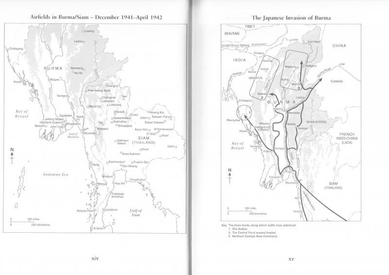
Excellent work, Kevin - can't wait to fly it ;-) I'm sure you are good for maps, but just in case:- Source: "The Burma Air Campaign 1941-1945" by Michael Pearson, Pen & Sword Aviation 2006 ISBN 1-84415-398-3 As a whisky-drinking Scotsman, I am particularly keen to see Johnny Walker, Highland Queen and John Haig Airfields included on this map Also, I notice you are going for a late-war front line - no worries, it's your call, and it fits in perfectly with the inclusion of Imphal and Kohima, but for that Flying Tigers Campaign we may need an alternate data set with the front line fixed with the Brits and the Tigers at Mingaladon, and the RAF fighting that last-ditch defence of Singapore - well, that's what Churchill wanted them to do! Happy to oblige for that if need be. Slainthe!
-
Has Anyone done a Balkans Campaign?NATO
Baltika replied to usafphantom2's topic in Mission & Campaign Building Discussion
Excellent news, thanks -
Has Anyone done a Balkans Campaign?NATO
Baltika replied to usafphantom2's topic in Mission & Campaign Building Discussion
Hi Baffmeister, no joy for me so far. ATM that is holding up further multi-tileset work on this terrain. I have Brain32's reworked photoreal GermanyCE set for the northern part of Europe, and Stary's Anatolia v1 tileset for the Med. I need to make some transition textures for where those sets meet, but that's no problem. I have IsraelME set listed in TE as a third working tileset for this terrain, but autotile in TE is too crude in its implementation of exclusion zones for me to make the IsraelME set appear only in North Africa. Stary's proposed solution to cut & paste parts of the tileset bmp is the perfect answer for that issue, but I keep getting the screwed up tileset bmp I showed in my earlier post. Stary has said something about saving the palette in PS to get it to work. It may be an issue that I use GIMP and PAINT.NET for all my editing work - I don't have PS. I will keep plugging away, and if I get a breakthrough, I'll let you know. I have resized this terrain slightly, but not rotated it, but who knows if that makes a difference? -
[Fictional] Scottish Electric Lightning F.6A 'Alba'
Baltika commented on Spinners's file in What If Hangar
 Brilliant work, thanks very much! Off to buzz Edinburgh!
 -
Has Anyone done a Balkans Campaign?NATO
Baltika replied to usafphantom2's topic in Mission & Campaign Building Discussion
Hi Brain32, PM inbound. "Somewhat" operational version is all I got, right now Let me know what you think. Cheers mate -
A Lightning for an Independent Scotland (1974)
Baltika replied to Spinners's topic in Sci-Fi/Anime/What If Forum
Superb, thanks very much. I'll shout you a pint -
A Lightning for an Independent Scotland (1974)
Baltika replied to Spinners's topic in Sci-Fi/Anime/What If Forum
Brilliant! Download please??? -
Topographic map (.tar) for Terrain Editor
Baltika replied to Peugeot205's topic in Mods & Skinning Discussion
Hi cangas, DEM data available here:- http://www.webgis.com/terr_world.html Slainthe! Baltika -
Reckoned you had it covered. Thanks for all the hard work
-
Happy to oblige, TE has become something of an obsession for me over the years, there's always something else to work out @Wrench, attached is a slightly modified Texturelist which should give a more realistic treeline and snowline for the Himalayas/Tibet/China. WW2CBI_TextureList.zip
-
Also on the subject of tiling, the Malay Peninsula, Sumatra and Borneo should be almost completely jungle-covered, with very little in the way of open fields. Again, this is down to the autotexture function, which is set pretty much to the stock VietnamSEA settings, with a few tweaks for snow etc. But again, I guess Wrench will have that covered ;-)
-
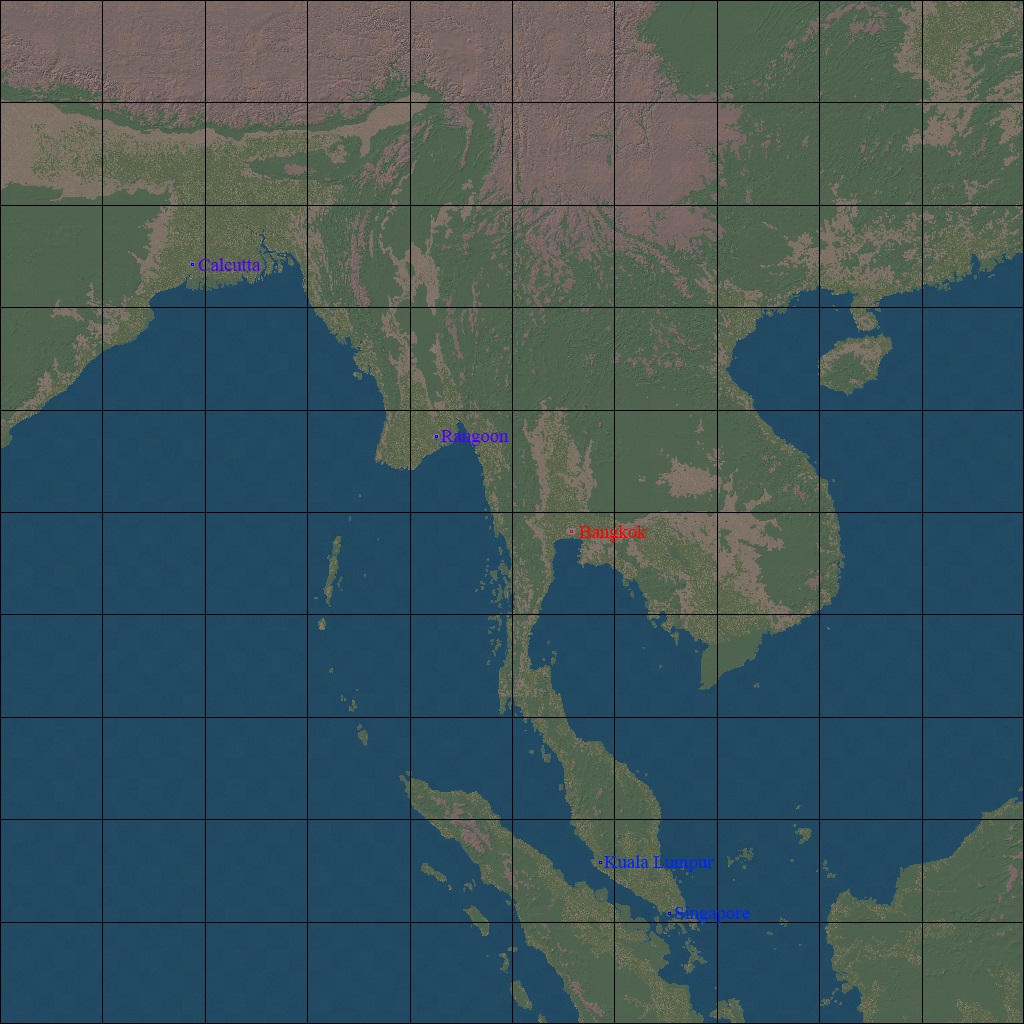
Hmmm, fair point re the snowline, quick check on google earth shows the snow is restricted to the high mountain peaks of the Himalayas, and the Tibetan plateau to the far north is some sort of arid desert/grassland type terrain. Wrench, I can tweak the autotile settings a bit to try to sort that out, although probably you have that covered I guess. Like Wrench says, the terrain is 2000km x 2000km in TE, however, I did not scale this up to full-scale using the heightfield-bitmap editing trick, so what you get is the raw TE data for TW terrains, which have 66% scale or so of reality. This is the same in all the stock terrains, and doesn't really seem to be an issue unless you are very particular about fuel capacity and a/c ranges. The reason for not upscaling this terrain is that the heightfield runs from the top of Everest (you can do a fly-past of Everest in the top left of the terrain, near the blue dot which marks the location of Khatmandu) right down to sea level. The export/import heightfield bitmap function in TE inevitably results in a loss of detail in the heightfield, especially at lower altitudes, and this would be the worst example of that data loss. So, this is perhaps a compromise, but hopefully an understandable one. Also, upscaling terrains in that way can result in a certain "blockiness" to mountain peaks, ranges and the like - look at my old Iceland02 terrain to see a bad example of this. That happened because the available dem data for Iceland is compressed in the north-south axis. When you expand the heightfield bitmap, you naturally lose resolution detail, just as with any bitmap which you enlarge. So, to keep the mountains looking suitably jagged, natural and mountainous, I did not upscale the heightfield for this project. Hope that answers the question! Wrench, thanks for taking this on, it's a huge project but should be a dream for the WW2 CBI players - as well as the other modern uses it could be put to. Personally, I'm really looking forward to rebuilding this old campaign for the new version of Burma:- http://combatace.com/files/file/9133-burma-air-war-the-longest-retreat-v10/ Slainthe! (Happy Burns Night 25th Jan!) Baltika
-
Swedish Campaign (The Scandinavian Front)
Baltika replied to JonathanRL's topic in Mission & Campaign Building Discussion
Excellent news! -
Hi Kevin, Check PMs, please. WW2 CBI terrain build inbound. Happy New Year to you BTW, I have tweaked the auto-texture settings a bit, so, for example, you won't see paddy fields on the Malay peninsula. But some things probably still need adjusting, for example, there are probably too many fields and not enough jungle on the Malay peninsula and on Sumatra. Also, I have had to hand-tile around areas like Kathmandu and Imphal, as the jungle will just swallow up the city tiles when you run auto-texture and then transition texture. If you place field tiles round the cities, then jungle round the fields, you can run transition texture without problems. Problem arises because there are no city to jungle or field to mountain transition tiles. Again, there may need to be a bit of further tweaking on the auto-texture settings for field tiles unless you want to hand-tile the whole darn map. Slainthe!
-
Updating SF2 Collection to latest standart
Baltika replied to Emp_Palpatine's topic in General Discussion
I have the same SF2 combo pack, and a number of other SF2 titles and DLCs. I use the Thirdwire auto-updater, available on TK's website, which will install everything you own and patch it up to the latest standard. Point and click. You need your login and password which TK supplied when you make an online purchase. Merry Xmas! -
Got it, thanks!
-
Perfect, thanks! I had been looking at your excellent Indo-Pak terrain, but that will save some work. I will get this "synched" to GH3 standard, add in those snow tiles, and fire it over to you.
-
Sure thing, will do. Can you tell me, is there a snow tile which fits in with the VietnamSEA set? This tileset could do with a snow tile for the Himalayas, otherwise Mount Everest is going to look a bit odd. Easy enough to add in, but rather than re-create the wheel, I am thinking maybe something like that was done for the Indo-Pak mod?
-
Hi Kevin, New map, no problem. TE will stitch the DEM files together for you. Here's the drill:- 1. Setup your new terrain folder in the usual way. 2. Open TE. Go to File/New dropdown. 3. New Terrain Dialog will open. 4. Set terrain map size (2000km, for your indicated area - that is one big map) 5. Leave Texture Tile Resolution and Height Field Resolution as stock (2000m and 500m respectively) 6. Click "OK" 7. Go to Edit/Import DEM on the TE toolbar 8. Import DEM Dialog will pop up. 9. Enter Lat/Long for top left of map (I used 82E 31N for this map) 10. Leave map scale at 100% 11. Heightscale I bump up to 110%, I like mountainous terrain! 12. Click OK on the dialog. 13. When you click OK, a selection window will pop up with the TE logo top left and the word "Open." At the bottom left of this box, in the selection field, highlighted in blue, is the name of the DEM file TE is looking for. in this case, it says E060N40.dem. Navigate to your saved DEM file, highlight it in the main panel, and click on "open" at bottom right. TE will process that file then ask for the next dem file in sequence. Work through each of them in turn. 14. That will give you your basic hfd in TE. To tile it, select your texturelist, VietnamSEA I guess, and create your citylist in the usual way. Using the above settings, I made a new .hfd in TE, then retiled using the VietnamSEA tileset. Saved the whole thing as a new terrain, then loaded it into gerwin's TFD tool to make this planning map:- If you like, I can zip this up and fire it over to you. Or, if you want a slightly smaller map, we can adjust the settings to suit - I couldn't resist fitting Singapore in there, given the map has to be square anyway.
-
Hmm, not sure what's going on here. I tried to convert this to create a new terrain, but it won't load into TE for me. This heightmap is 1000x1000 pixels, so it should be a simple case of creating a new terrain TE, size 500km x 500km, then selecting the import heightmap from bitmap option. But the imported heightmap is just showing up blank. TE is picky about format, so I have converted to .bmp, indexed colors, 8-bit depth, but still no go. Maybe something is being lost in the conversion process to jpg and back? Or, can you create a new terrain folder with the old hfd and tfd files, but using the SEA textureset and texturelist, and see if autotexture will work?