
gerwin
-
Posts
822 -
Joined
-
Last visited
-
Days Won
8
Content Type
Profiles
Forums
Gallery
Downloads
Store
Everything posted by gerwin
-
I tried to increase it again, but things are starting to freak out!!!?? Compiler errors at 8000 tiles. Empty dialogs at 6000 tiles. 2000x2000 tiles and 4000x4000 tiles gave no such problems. So I don't know what to do yet...
-
SidDogg, I uploaded v0.80 which should work with 4000x4000 tilesets. This has not been tested though, the biggest terrain on my PC is 750x750.
-
For me it is very easy to increase it. Only the memory usage goes up a little, should not be a problem really. What Width/Height do you want to work on?
-
 Also these 23mm rounds do not explode in reality.
 -
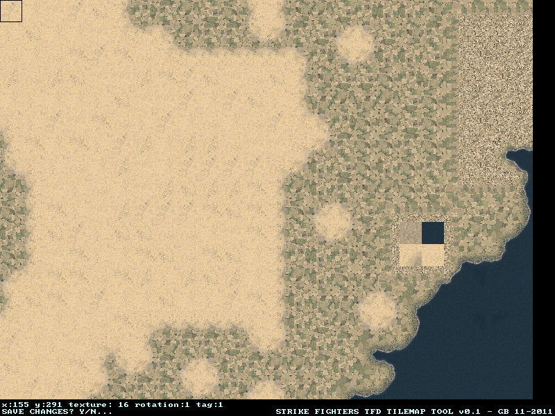
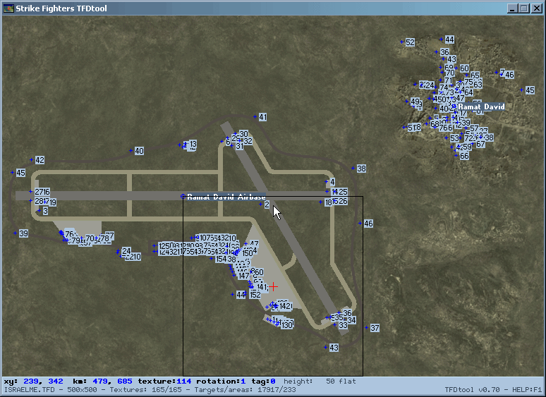
Glad you like it so far. I don't get your remark about the IsraelME tileset, TFDtool should work with any tileset. just tried it on IsraelME and it runs fine. my 8MB upload limit is reached, so here it is on Imagebam: RIght now it just puts a grid dividing the entire map in 10x10 squares, regardless of map size. I don't know if that is OK.
-
It did not take that much time to add it, hope this works for you: http://combatace.com/topic/68667-alternate-tfd-terrain-tilemap-editorviewer/
-
I will try to at least allow saving without exitting. v0.79 was up for a while in different forms, it now has the following changes: - Uses backbuffer in memory for smoother scrolling. - Redefined export keys and options. - Can export an image of the tilemap with the embossed heightmap as an overlay. - Can export the three Planning Maps: 512, 1024 and 2048 pixels wide. (I would like to know what info should and should not be in the planningmaps... ) - some small improvements below the smallest of the three planningmaps, GermanyCE. I decided to put text only in the larger two planningmaps.
-
I have been thinking about adding planningmap generation to TFDtool. If you use the latest version you can export an embossed map (showing both the tiles and height) In the future that has to be stretched to 512,1024 and 2048 pixels, with the Airfield names and a grid on top... Well that sounds a lot easier than it is.
-
v0.78 -Releases the CPU when nothing is happening -Print Screen Key now functional -Tweaked heightmap palette a little
-
Thanks for reporting this so clearly, it helped me to find the cause quickly. Please try v0.77. PS: I uploaded a newer version, but still v0.77, build time 21:48. This one can run properly at 1024x794.
-
? Does not compute.. v0.76 tiny update. Height to grayscale export, height increment autodetect, better key handling.
-
v0.75 is up. -Proper documentation file. -Can now export the water bitmap for the SF2 mission editor. -Tweaked Heightmap palette. -Heightmap can be adjusted at its native resolution.
-
If you made any changes to either the Tilemap TFD or the Heightmap HFD you just have to exit the program (hit ESC, or click the close button top right) and the program will then ask you if you want to save the changes to the Tilemap TFD and/or the Heightmap HFD. Click 'yes'. If you did not make any changes it will not ask about saving. The export buttons are just a small bonus, there is no particular use for the exported images (yet). Since v0.73 it is very easy to do so with pgup/pgdn keys in height mode (lower tile to zero-flat first, then raise to desired height.) it is also possible with cut/paste (D/F keys).
-
v0.71 Added displaying the heightmap .HFD at all zoom levels. with rainbow-like colors. Toggle between the two viewmodes with the m key. v0.72 Added height labels at full zoom. Added some basic support for editing the heightmap with the same keys/functions as editing the tilemap. So the effect of the R,T, pgup/pgdn keys differ according to the viewmode: tiles or height. Tweaking a heightmap is currently far from perfect. It was never intended to be a HFDtool anyways.
-
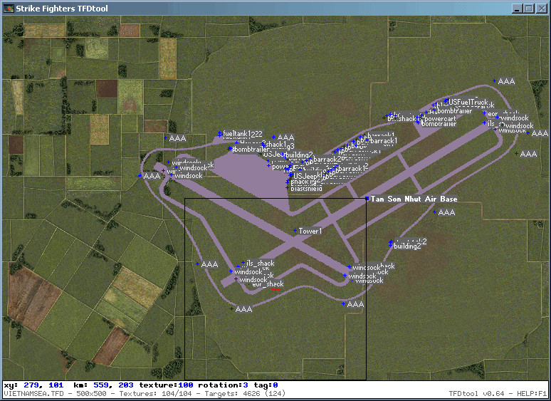
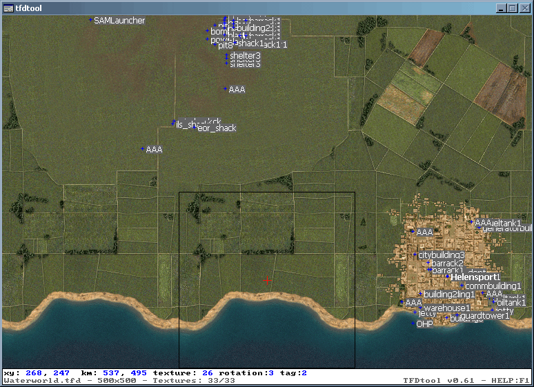
It is getting better still: v0.66 added alternate targets tag display, using tab: All off -- target dot only -- dot+name label -- dot+entry no. label -- dot+offset X/Y v0.66 added a lick of blue paint to the interface. v0.70 adds basic Heightmap (.HFD) display and editing. Allowing me to flatten these sunken runways in VietnamSEA (Kien An / Bai Thoung). use D to copy the tile height values to clipboard, F to paste it on another tile. Note that there are 4x4=16 heightmap values per tile.
-
V0.65 is up Runways are drawn much better now. Runway Icons look different from other targetareas. Minor Target indicators and labels are now turned off by default, to show them press M or L. For Minor Target labels you have to be fully zoomed in.

-
TFDtool v0.64: Supports runway headings other then the default + Shows stock Airfield previews + New Fonts.
-
I fixed the slow target reading in v0.62.
-
v0.61 is up. Y coordinates are now proper (reversed) It can display targetarea's and targets. Though with bigger Target.ini files, loading times are increasing. A different method of parsing the ini file may be necessary. Currently I use the stock config-file file parser from the allegro game programming library There is a TFDtool.ini with a few options, mainly to allow people to set up a bigger window depending on their screen limits. Do me a favor and postpone feature request for a week or so, I really need to give this a break. ;) At least one can now check target placement without running the game. To some extend at least, as an even higher zoom may be required....
-
v0.5 is up, Try it with high res textures now.
-
There is not much 'planned' actually. v0.4 is up.
-
you don't have to ;) you can download it as it is now. v0.3 is up: -Shows coordinates in kilometers too. -Uses bilinear scaling to smoothen the textures when zoomed out. -R key also rotates
-
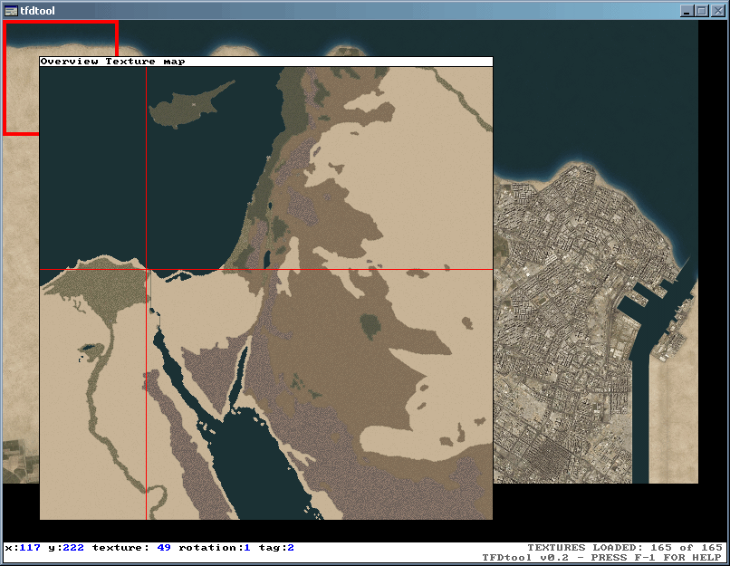
Thanks for the good response! At max zoom in you can see the 256x256 tiles full size. The max zoom out is a seperate overview window showing the whole map. The M key shows a map with tag values (0,1 or 2). I don't know much about these tag values. GermanyCE does not even have them. If I would add support for larger textures I would probably just go about it like this: Resize tile to 256x256 right after loading the bmp/tga. So it will then work with larger tiles without manual conversion, but will not show the full detail. I adjusted some details in VietnamSEA and your Waterworld with this tool. It works best using C to copy the necessary tile, then V to paste it somewhere, then HOME to rotate it.
-
Okay guys, a new version (0.2) is up on the location given in the first post. Much has changed! not even going to bother listing the changes. I tried to listen to everyone's feedback, but haven't come to adding support for tiles other then 256x256 size. Also still requires ansi data ini files. The weekend is almost over, so for now this has to do.
-
This evening I made a little tool that can open terrain tilemaps (TFD). The intentention is to fix some strange tile placements in VietnamSEA. Only tested it briefly, all seems to work well so far, (I never had much luck with the official Thirdwire TerrainEditor myself.) http://www.gb-homepage.nl (click on the Strike Fighters page, there you can find the download)