Menrva
-
Posts
4,583 -
Joined
-
Last visited
-
Days Won
47
Content Type
Profiles
Forums
Gallery
Downloads
Store
Everything posted by Menrva
-
-
Ditto that. Wish you and your family the best, 76.IAP-Blackbird.
-
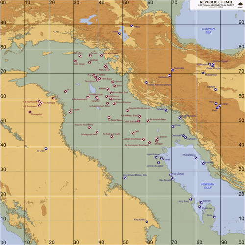
Exactly. It took me three years to develop the Iran/Iraq terrain. I am grateful to all of those who waited for it. I put so much effort into it, and I am a little afraid some people don't even notice it. Other incredible, great modders around here have provided the community with outstanding stuff, all for free. They say, to share is to care. Also, let's not forget, patience is a virtue.
- 471 replies
-
- 5
-

-
- fitter
- sf2 fitter
- (and 3 more)
-
Me too, I like reading aviation related news. Man, I can't believe it. Who needs Ace Combat's fictional aircraft fortresses? We are getting closer to such fiction.
-
Wow, nice! Thank you, gerwin, I really like your work. Your 3D models (including airbases) and TFDtool are masterpieces.
-
 Good to see you're back, viper63a! Thanks for sharing this nice package!
 -
Nice addition indeed! Maybe one day we will see an updated ODS campaign package with my accurate terrain remake. I keep on dreaming.
-
"Ripping Falcon" here, reporting for duty! I prefer owls over falcons, though, LOL!
-

Where the frak? Pipper/Gunsight/HUD thingy gone... :-(
Menrva replied to Muesli's topic in General Discussion
It once happened to me a long of time ago, but I don't remember exactly how I fixed it. Check if you have a custom AIRCRAFTOBJECT.ini inside the Objects folder, and remove it. As far as I remember, once I messed around with some custom .ini files from Stary, and I got that bug. -
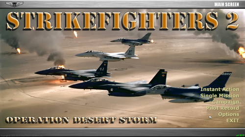
I released a standalone, updated terrain (which hopefully will receive another update later this month): http://combatace.com/files/file/16395-iraq-western-asia-1980-2003/ The campaign files must be edited so that the new terrain can be used.
-
Yes, that's the one, thanks mate!
-
Damn, now I remember. The version I was telling about was actually a video from YouTube. I might be able to find it again. Thanks, Skyviper!
-
Yeah, an old one. IIRC, the version I read had the Spanish in place of the Canadians. Still funny though.
-
I am planning updates to my old terrains and some new terrain releases, and I was wondering if I could find a way to make better looking planning maps, very similar to the stock SF ones. Spectre8750 managed to make some of them for other custom terrains, such as this: http://combatace.com/topic/75208-alternate-kaw-terrain-v3-planning-map-set/. Does anybody have any suggestions or the perfect, secret recipe? Thanks in advance.
-
OffMapAirbase; how to determine (negative) coordinates?
Menrva replied to Menrva's topic in Mods & Skinning Discussion
Don't worry EMCON360! You answered my question anyway, you didn't hijack the thread. BTW, Google Earth is what I primarily use for terrain making, as well as other sources of info. -
Thanks for sharing this one. Very interesting!
-
 SUDNAVY, most painting software should do ok, I use Paint.NET, reopen that _water bitmap and save it as 8bit.
 -
Welcome back!
-
Please use the following support topic when reporting bugs: http://combatace.com/topic/90262-iraq-western-asia-1980-2003/ This space is meant to be used for overall reviews, not for bug reporting. Anyway, thanks for pointing that out. Turns out that the _water bitmap was wrongly saved. Just re-open the _water.bmp file and re-save it as 8-bit and you're good to go. I won't bother to update the package just for this. Fix will be included in next release.
-
Care to Educate a Fool?
Menrva replied to Skyviper's topic in Mission & Campaign Building Discussion
Isn't YAP based on WOV? SF2 is not as open as SF1, it's way more locked. You no longer can fool the game into doing something that is not supposed to, not so easily. Refueling can't be done in SF2 anymore (there was a cheat/mod working for SF1 games). I'll say again, the source code is the mother of everything. -
Care to Educate a Fool?
Menrva replied to Skyviper's topic in Mission & Campaign Building Discussion
Hmm, I am afraid that without the source code, we won't be able to make proper scripts. By looking into the .dll files, one can see that TK added (only as placeholders, without any code) mission types such as AIR_ASSAULT, TRANSFER, TRAINING, SCRIPTED, SPECIAL_ATTACK, and many others. There are so many placeholders for other things too. That's what bothers me. SF2 really does have an incredible potential. However, the code is locked. Without source code, I think the only option is reverse engineering, but that is most of the time illegal. -
Care to Educate a Fool?
Menrva replied to Skyviper's topic in Mission & Campaign Building Discussion
Can you be more precise, SkyViper? Your question is interesting. -
PFunk, you still working on this? I can always provide support with that heightmap.
-
I'm planning to see it. I had the impression it was an interesting movie, and it is based on a true story as well.
-
 Beautiful! Thanks for sharing yet another masterpiece, yakarov79!