

Baltika
-
Posts
1,293 -
Joined
-
Last visited
-
Days Won
1
Content Type
Profiles
Forums
Gallery
Downloads
Store
Everything posted by Baltika
-
Swedish Campaign (The Scandinavian Front)
Baltika replied to JonathanRL's topic in Mission & Campaign Building Discussion
Here is an example taken from my as-yet-unpublished 2009 North Cape campaign. It features a Norwegian front and a Finland/Russia front. It is alpha only as I need to set the basepoint= co-ordinates for some strategic nodes, as tanks are attacking over sea, or up impossible hills, etc. Default works fine for flat terrain, so you can leave those entries blank if you wish. This is also very basic as most of the map is, as yet, unused. But, it does work. These are relevant excerpts from the campaign_data.ini file:- [CampaignData] StartDate=07/10/2009 StartDateDeviation=0 EndDate=01/31/2010 ForceWithInitiative=0 MaxMissions=60 NormalMissionRate=3 NormalMissionRateDeviation=1 OffensiveMissionRate=1 OffensiveMissionRateDeviation=0 StartScreen=NORTHCAPE09START.BMP StartText= CampaignBaseScreen=NORTHCAPE09BASE.BMP CampaignEndWinScreen=NORTHCAPE09BLUEWIN.BMP CampaignEndLoseScreen=Loser1.bmp CampaignEndStallScreen=Winner1.bmp CampaignEndWinText=NCWin.txt CampaignEndLoseText=NCLose.txt CampaignEndStallText=NCWin.txt [Force001] Alignment=FRIENDLY Nation=USN BaseArea=NARVIK AirOffensive[001].Primary=LARGE_RUNWAY,MEDIUM_RUNWAY AirOffensive[001].Secondary=WAREHOUSE AirOffensive[002].Primary=COMM_BUILDING,EW_RADAR AirOffensive[002].Secondary=LARGE_RUNWAY,MEDIUM_RUNWAY AirOffensive[003].Primary=FUEL_STORAGE,AMMO_STORAGE,WAREHOUSE AirOffensive[003].Secondary=LARGE_RUNWAY,MEDIUM_RUNWAY AirOffensive[004].Primary=COMM_BUILDING,EW_RADAR AirOffensive[004].Secondary=LARGE_RUNWAY,MEDIUM_RUNWAY AirOffensive[005].Primary=FUEL_STORAGE,AMMO_STORAGE,WAREHOUSE AirOffensive[005].Secondary=LARGE_RUNWAY,MEDIUM_RUNWAY,COMM_BUILDING,EW_RADAR AirOffensive[006].Primary=LARGE_RUNWAY,MEDIUM_RUNWAY AirOffensive[006].Secondary=COMM_BUILDING,EW_RADAR,FUEL_STORAGE,AMMO_STORAGE,WAREHOUSE AirOffensive[007].Primary=BRIDGE AirOffensive[007].Secondary=COMM_BUILDING,EW_RADAR,FUEL_STORAGE,AMMO_STORAGE,WAREHOUSE AirOffensive[008].Primary=BRIDGE AirOffensive[008].Secondary=LARGE_RUNWAY,MEDIUM_RUNWAY,COMM_BUILDING,EW_RADAR AirOffensive[009].Primary=COMM_BUILDING,EW_RADAR AirOffensive[009].Secondary=LARGE_RUNWAY,MEDIUM_RUNWAY,FUEL_STORAGE,AMMO_STORAGE,WAREHOUSE AirOffensive[010].Primary=ANY AirOffensive[010].Secondary=ANY StartGroundOffensive=8 StartInterdiction=0 Morale=80 Supply=40 NormalSupplyRate=28 OffensiveSupplyRate=-10 DefensiveSupplyRate=-3 SupplyForOffensive=70 AircraftReplacementTime=15 AircraftReplacement=30 GroundUnitReplacementTime=15 GroundUnitReplacement=100 RandomTransportType=ANY WeaponResupplyTime=7 StartAirDefenseLevel=3 AllowRandomAceCreation=TRUE [Force002] Alignment=ENEMY Nation=SOVIET BaseArea=MURMANSK AirOffensive[001].Primary=LARGE_RUNWAY,MEDIUM_RUNWAY AirOffensive[001].Secondary=WAREHOUSE AirOffensive[002].Primary=COMM_BUILDING,EW_RADAR AirOffensive[002].Secondary=LARGE_RUNWAY,MEDIUM_RUNWAY AirOffensive[003].Primary=FUEL_STORAGE,AMMO_STORAGE,WAREHOUSE AirOffensive[003].Secondary=LARGE_RUNWAY,MEDIUM_RUNWAY AirOffensive[004].Primary=COMM_BUILDING,EW_RADAR AirOffensive[004].Secondary=LARGE_RUNWAY,MEDIUM_RUNWAY AirOffensive[005].Primary=FUEL_STORAGE,AMMO_STORAGE,WAREHOUSE AirOffensive[005].Secondary=LARGE_RUNWAY,MEDIUM_RUNWAY,COMM_BUILDING,EW_RADAR AirOffensive[006].Primary=LARGE_RUNWAY,MEDIUM_RUNWAY AirOffensive[006].Secondary=COMM_BUILDING,EW_RADAR,FUEL_STORAGE,AMMO_STORAGE,WAREHOUSE AirOffensive[007].Primary=BRIDGE AirOffensive[007].Secondary=COMM_BUILDING,EW_RADAR,FUEL_STORAGE,AMMO_STORAGE,WAREHOUSE AirOffensive[008].Primary=BRIDGE AirOffensive[008].Secondary=LARGE_RUNWAY,MEDIUM_RUNWAY,COMM_BUILDING,EW_RADAR AirOffensive[009].Primary=COMM_BUILDING,EW_RADAR AirOffensive[009].Secondary=LARGE_RUNWAY,MEDIUM_RUNWAY,FUEL_STORAGE,AMMO_STORAGE,WAREHOUSE AirOffensive[010].Primary=ANY AirOffensive[010].Secondary=ANY StartGroundOffensive=0 StartInterdiction=0 Morale=100 Supply=100 NormalSupplyRate=24 OffensiveSupplyRate=-8 DefensiveSupplyRate=-3 SupplyForOffensive=50 AircraftReplacementTime=30 AircraftReplacement=30 GroundUnitReplacementTime=30 GroundUnitReplacement=100 RandomTransportType=ANY WeaponResupplyTime=15 StartAirDefenseLevel=3 AllowRandomAceCreation=TRUE * * * * * * * * * * * * * * * [GroundUnit001] GroundObjectType=Leopard1A4 UnitName=Armoured Battalion, ESK 2 ForceID=1 Nation=Norway BaseArea=NARVIK RandomChance=100 StartObjects=100 MaxObjects=100 Experience=80 Morale=80 Supply=50 UpgradeType=NEVER [GroundUnit002] GroundObjectType=Leopard1A4 UnitName=Telemark Battalion ForceID=1 Nation=Norway BaseArea=KIRKENES RandomChance=100 StartObjects=100 MaxObjects=100 Experience=80 Morale=80 Supply=50 UpgradeType=NEVER [GroundUnit003] GroundObjectType=Leopard1A4 UnitName=Guard Jaeger Regiment ForceID=1 Nation=Finland BaseArea=HELSINKI RandomChance=100 StartObjects=100 MaxObjects=100 Experience=80 Morale=80 Supply=50 UpgradeType=NEVER [GroundUnit004] GroundObjectType=Leopard1A4 UnitName=Häme Armoured Battalion ForceID=1 Nation=Finland BaseArea=VAALIMAA RandomChance=100 StartObjects=100 MaxObjects=100 Experience=80 Morale=80 Supply=50 UpgradeType=NEVER * * * * * * * * * * * //---- WP Ground Units // Leningrad Military District [GroundUnit005] GroundObjectType=T-72A UnitName=2nd Spetznaz Brigade ForceID=2 Nation=Soviet BaseArea=MURMANSK RandomChance=100 StartObjects=100 MaxObjects=100 Experience=100 Morale=100 Supply=80 Intelligence=100 UpgradeType=NEVER [GroundUnit006] GroundObjectType=T-72A UnitName=25th Gv. Mt. Rifle Brig. ForceID=2 Nation=Soviet BaseArea=OLENEGORSK RandomChance=100 StartObjects=100 MaxObjects=100 Experience=80 Morale=80 Supply=50 Intelligence=100 UpgradeType=NEVER [GroundUnit007] GroundObjectType=T-72A UnitName=138th Gv. Mt. Rifle Brig. ForceID=2 Nation=Soviet BaseArea=VYBORG RandomChance=100 StartObjects=100 MaxObjects=100 Experience=80 Morale=80 Supply=80 Intelligence=100 UpgradeType=NEVER [GroundUnit008] GroundObjectType=T-72A UnitName=200th Gv. Mt. Rifle Brig. ForceID=2 Nation=Soviet BaseArea=SANKT-PETERBURG RandomChance=100 StartObjects=100 MaxObjects=100 Experience=80 Morale=80 Supply=50 Intelligence=100 UpgradeType=NEVER * * * * * * * * * * * * * * * [strategicNode001] Area=Olenegorsk ConnectTo[001].Target=Murmansk [strategicNode002] Area=Murmansk ConnectTo[001].Target=Olenegorsk ConnectTo[002].Target=Kirkenes [strategicNode003] Area=Kirkenes ConnectTo[001].Target=Murmansk ConnectTo[002].Target=Hammerfest [strategicNode004] Area=Hammerfest ConnectTo[001].Target=Kirkenes ConnectTo[002].Target=Tromsø [strategicNode005] Area=Tromsø ConnectTo[001].Target=Hammerfest ConnectTo[002].Target=Narvik [strategicNode006] Area=Narvik ConnectTo[001].Target=Tromsø [strategicNode007] Area=Sankt-Peterburg LocalObjective=TRUE ConnectTo[001].Target=Sestroretsk [strategicNode008] Area=Sestroretsk ConnectTo[001].Target=Sankt-Peterburg ConnectTo[002].Target=Roshchino [strategicNode009] Area=Roshchino ConnectTo[001].Target=Sestroretsk ConnectTo[002].Target=Vyborg [strategicNode010] Area=Vyborg ConnectTo[001].Target=Roshchino ConnectTo[002].Target=Vaalimaa [strategicNode011] Area=Vaalimaa ConnectTo[001].Target=Vyborg ConnectTo[001].BasePoint=1174567,282765 ConnectTo[002].Target=Kotka [strategicNode012] Area=Kotka ConnectTo[001].Target=Vaalimaa ConnectTo[002].Target=Porvoo [strategicNode013] Area=Porvoo ConnectTo[001].Target=Kotka ConnectTo[002].Target=Helsinki [strategicNode014] Area=Helsinki LocalObjective=TRUE ConnectTo[001].Target=Porvoo * * * * * * * * * * * * * * * * -
Swedish Campaign (The Scandinavian Front)
Baltika replied to JonathanRL's topic in Mission & Campaign Building Discussion
Hi Jonathan, I am more than happy to help out, I have scripted a few campaigns in my time, and setting up the groundwar can be frustrating. I don't have much spare time just now, but if you want to send me what you have I can take a look at it, or, if you need some pointers, just ask away. You need to define a network of strategic nodes in the campaign data.ini file. Each force must have a base node, as defined under each [FORCEXXX] entry at the head of the campaign data ini file. You must define the strategic nodes so that each basenode is connected to the other one through the network of strategic nodes - think of "join the dots." Ground units can only appear at strategic nodes as defined in the campaign data ini. Getting the force to attack depends on setting supply and morale levels for each force, and for each unit. Under each [FORCEXXX] header, there are variables which control when attacks are launched. I suggest keep it simple at first - define each force's base node (eg Helsinki for blue force and Sankt-Peterburg for red force), then connect them through a single chain of strategic nodes. For example, Sankt-Peterburg -> Roshchino -> Vyborg Red Army Base -> Vaalimaa -> Kotka -> Porvoo -> Helsinki. Set your ground units to show up on the links in that chain, and you should have a basic, working ground war. Then you can define different chains for each "front," i.e. one through Sweden and one through Norway. Each chain has to be connected to the base node. That should get you started. Any questions, fire away. Slainthe, Baltika -
 Just checked out your recon shots in the SF2 screenshot thread. . . Nice You got it, Great Cthulhu Given you made it back to base, I have to toughen up those air defences
 -
View File Kamchatka Peninsula for SF2 Kamchatka Peninsula v2.0 by Baltika For Strike Fighters 2 Series This is an upgrade of my original Kamchatka Peninsula Terrain to bring it up to the latest SF2 standard (September 2011 patch). I was motivated to bring it up to speed to provide a native combat environment for TK's excellent JASDF Phantom F-4EJ, available at the Thirdwire DLC Store. What's new over version 1.0: -Fully compatible with SF2 -Winter and Summer tilesets -Fully operational in Thirdwire Mission Editor (Cheers Crusader!) This terrain includes a base tileset by Deuces, together with Stary's forests and farms mod adapted for use on this terrain. I have also created a large number of additional transition tiles based on Deuce's tiles, which may be of interest to terrain builders. This version 2.0 release also includes a full winter tileset, which is based on Major Lee's DBS terrain tileset. Thanks also to Wrench for creating the water effect .TGA tiles used here which bring the water to life. The tile naming format is compatible with the stock GermanyCE tileset for ease of expansion, but be aware that the excellent hi-res and seasoned tilesets by Brain32 and Stary in particular will not have all the necessary transition tiles, so use them with caution. Should you wish to use the included transitioned tileset for your own terrain mods, copy all the terrain .bmp files and .tga files into the "Tileset" folder and convert the .tga tiles to .bmp format. See Gepard's excellent terrain tutorials in the KB at CA for more info. All mission types are activated, for both red and blue side flyable. The Americans have their existing bases on the Aleutian Islands. I have handed the northern Kuril Islands to the Japanese for the sake of this scenario. Take it as read that the Soviets were sufficiently distracted by the ground war in central Europe that they lost their hold on the Kurils to Japan. Now, the Soviets are engaged in a fierce battle for control of the strategically important Kamchatka Peninsula. This is a target-rich, fictionalised version of the RUssian Far East. There are many installations and industrial zones in the Kamchatkai Krai that you will not find in real life. Equally, as much real-life stuff as I could discover went into the mix. Also, this is a showcase of a fully-transitioned tileset, so there is much more agriculture than you would get at these latitudes. Just kick back and enjoy the scenery. Finally, there is a monstrous presence lurking at the heart of the Peninsula who has risen from aeons of deathless sleep to trouble the affairs of men once more. Bragging rights to the first person to take a recon photo of this horror and make it back to base alive, and with their sanity intact ;-) INSTALLATION:- Simply unzip and drop the "KAMCHATKA" folder into your User\Saved Games\Thirdwire\StrikeFighters2\Terrains folder. It is highly recommended that you install the files listed below or you will not get the full intended Kamchatka Krai experience. RECOMMENDED FILES:- Groundobjects:- CVN-75 by Digital Overload http://forum.combatace.com/index.php?app=downloads&showfile=9684 TAKR Orjol by Gepard http://forum.combatace.com/index.php?app=downloads&showfile=5497 TAKR Admiral Gorshkov by X-RAY http://forum.combatace.com/index.php?app=downloads&showfile=5830 UdaloyI by China Insky Team http://forum.combatace.com/index.php?app=downloads&showfile=10336 UdaloyII by China Insky Team http://forum.combatace.com/index.php?app=downloads&showfile=10330 BRDM_SA-9 by rebelryder http://forum.combatace.com/index.php?app=downloads&showfile=7740 SA-11 & SA-17 by 101tfs http://forum.combatace.com/index.php?app=downloads&showfile=7627 ScudLauncher & Missile by bigal1 http://forum.combatace.com/index.php?app=downloads&showfile=6435 Soviet SAMs by gabilon http://forum.combatace.com/index.php?app=downloads&showfile=3057 CREDITS:- Core tilesets by Deuces and Major Lee. Additional transition tiles by Baltika Winter Sea .TGA tiles by Wrench Forests and Farms mod by Stary, extended to cover additional tiles Kamchatka_water.bmp by Crusader Doppler Radar Dome by grumpapotamus I have modded this as a terrain object rather than a separate ground object. The original readme file is included. Thanks grumpapotamus ;-) WW2 Subpens from WW2 Europe Terrain by Edward et al, modded for Soviet use. Thanks to the original creator. As ever, feedback, comments, bug-reports and general griping are most welcome. Slainthe! Baltika September 2011 Submitter Baltika Submitted 09/21/2011 Category Full Terrains
-
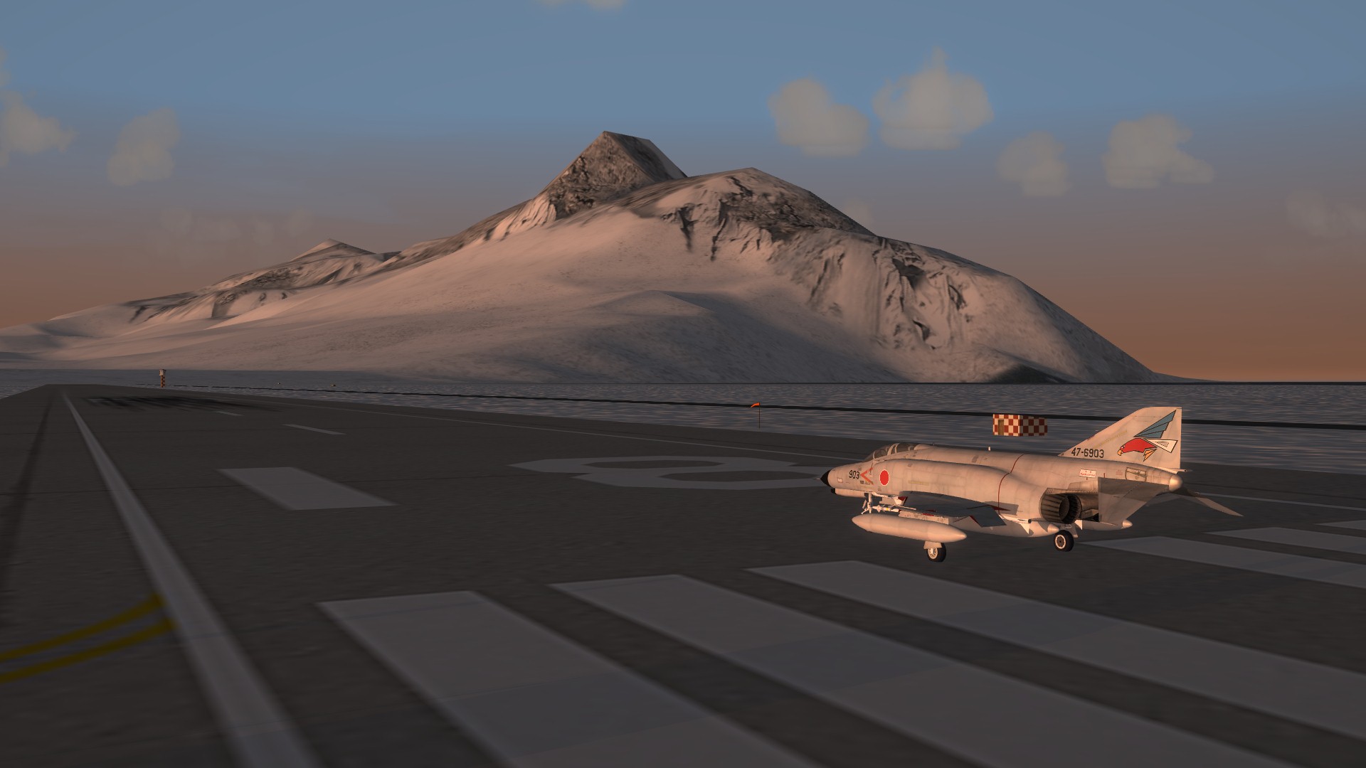
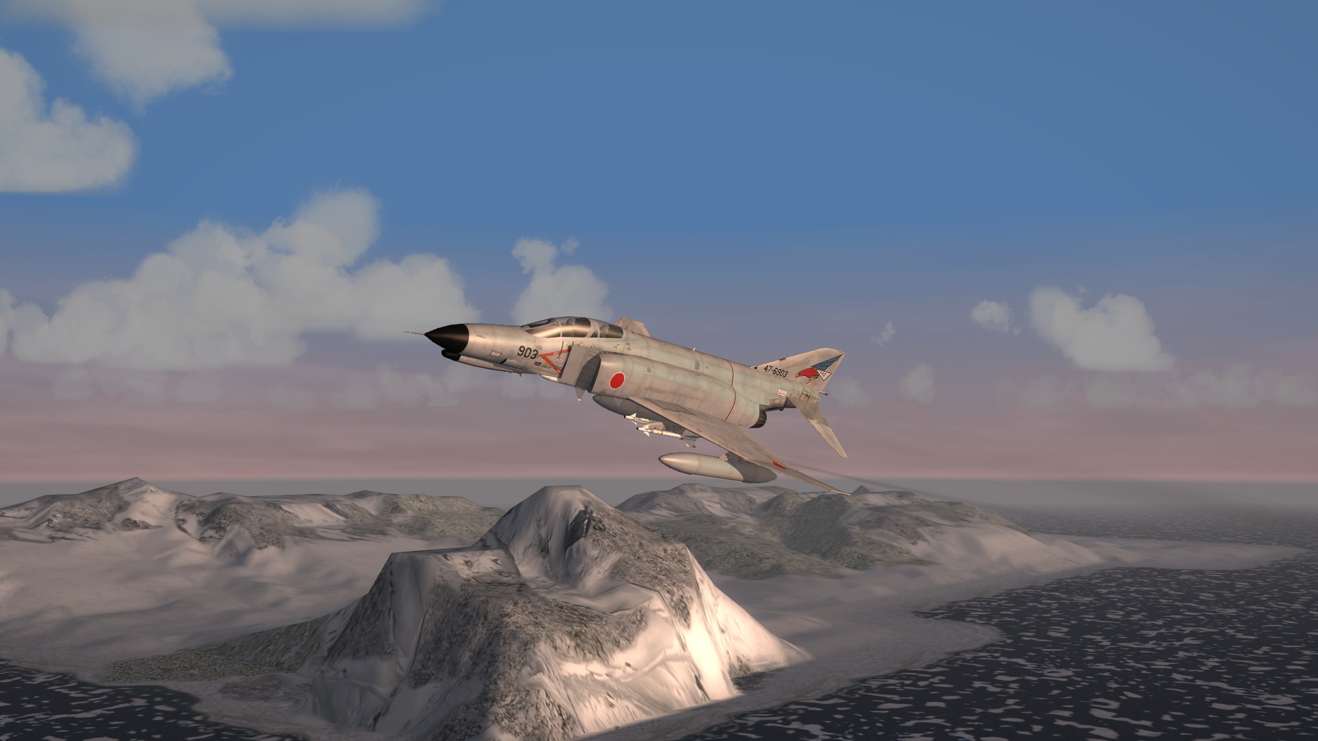
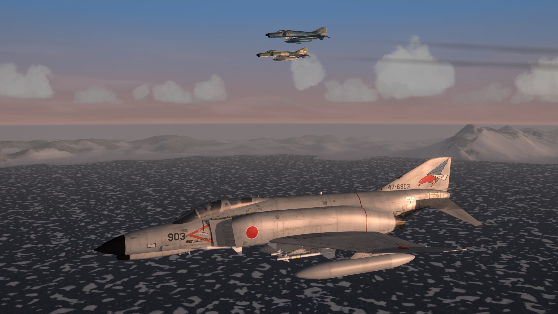
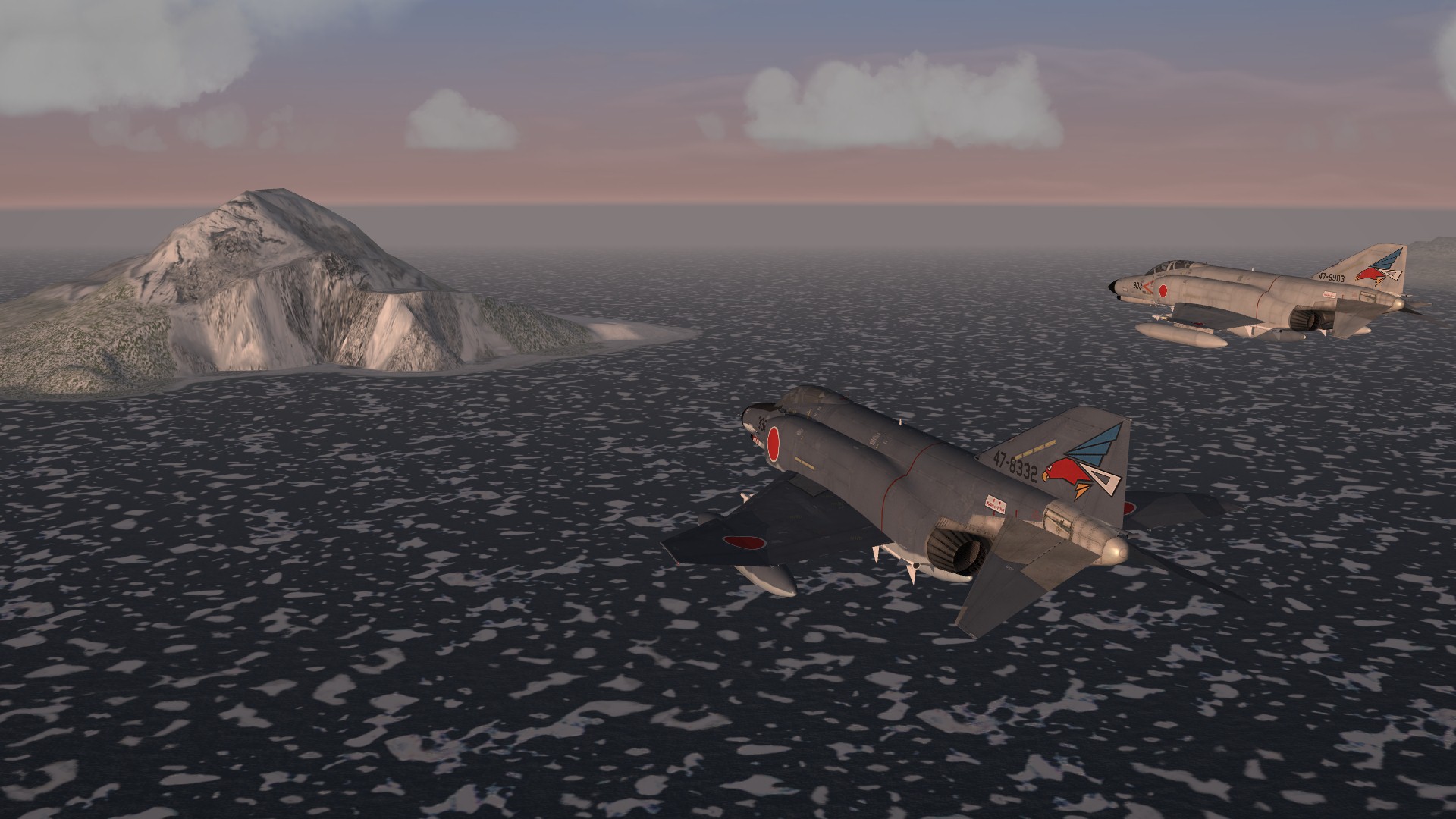
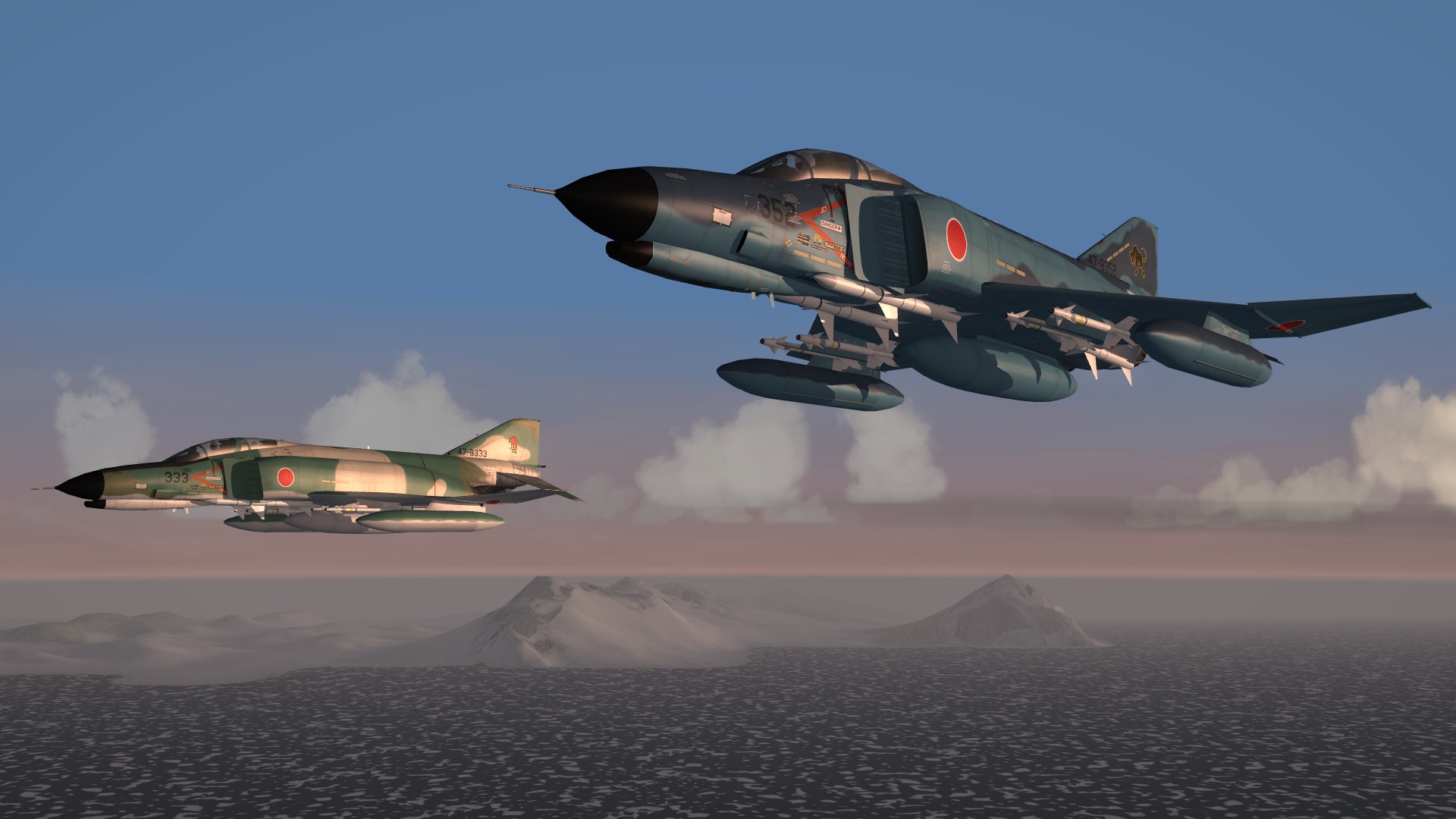
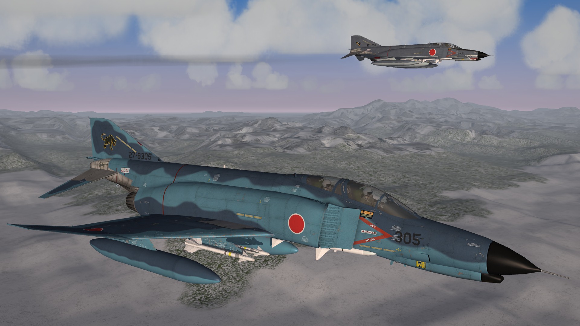
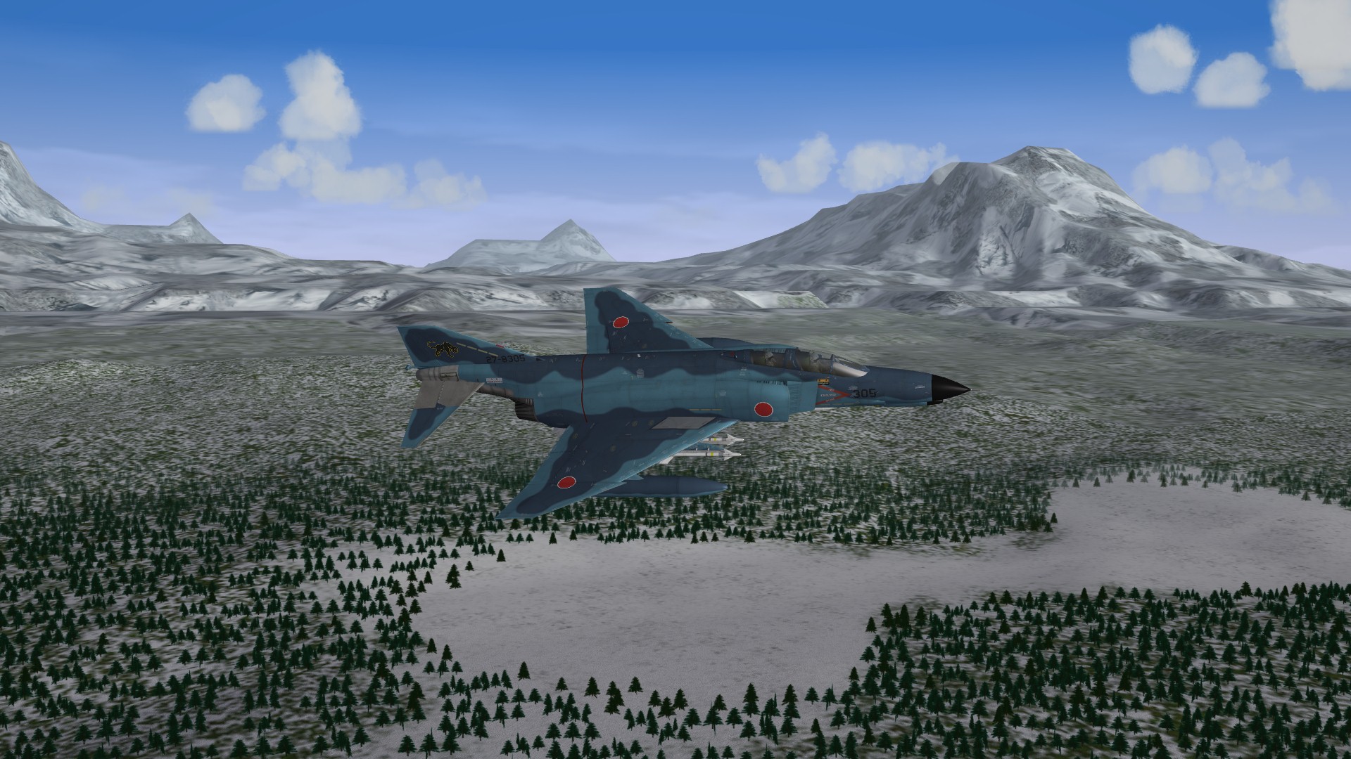
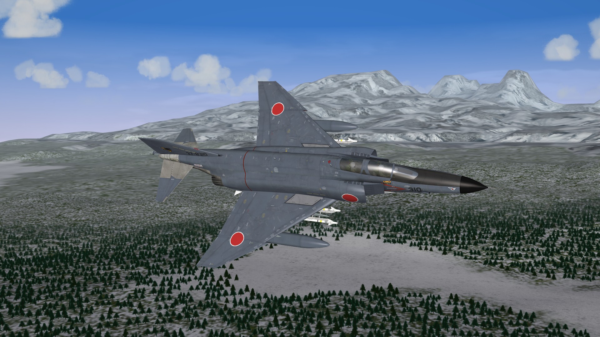
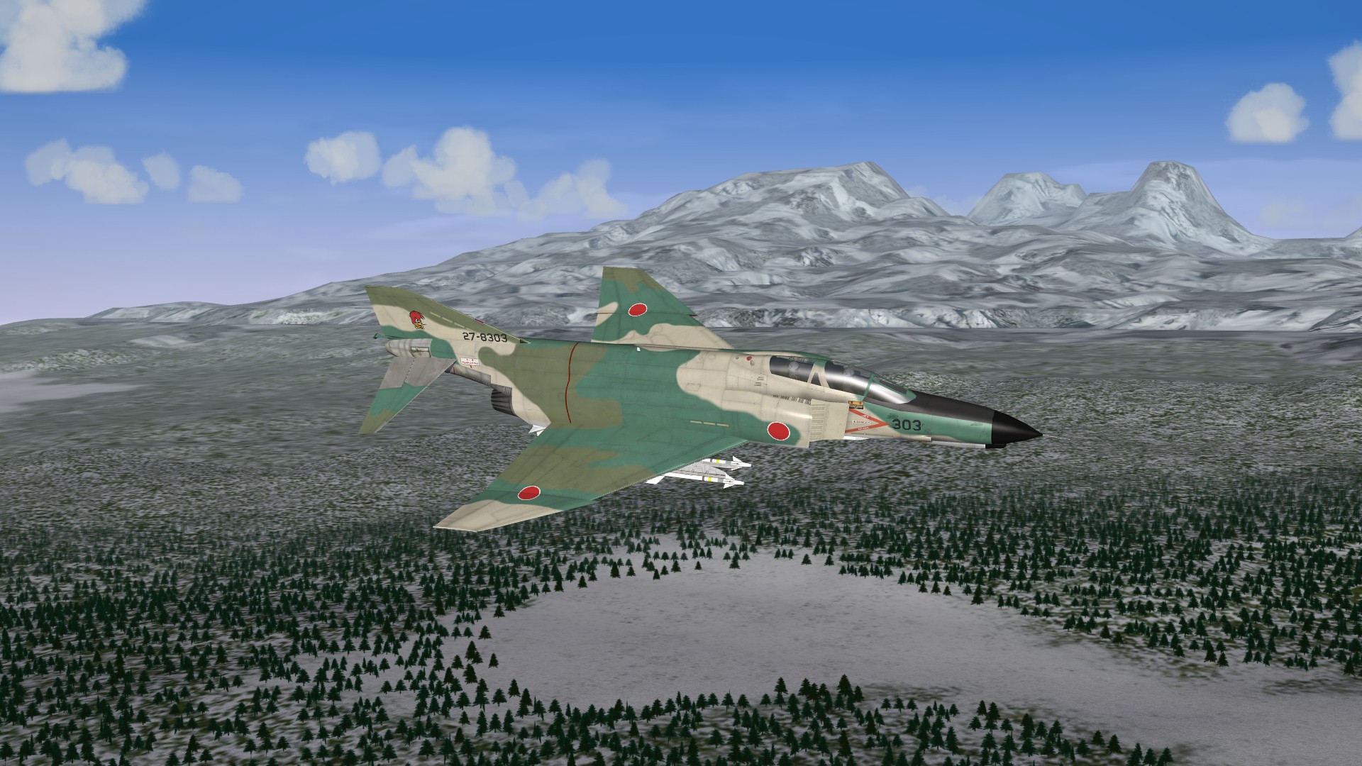
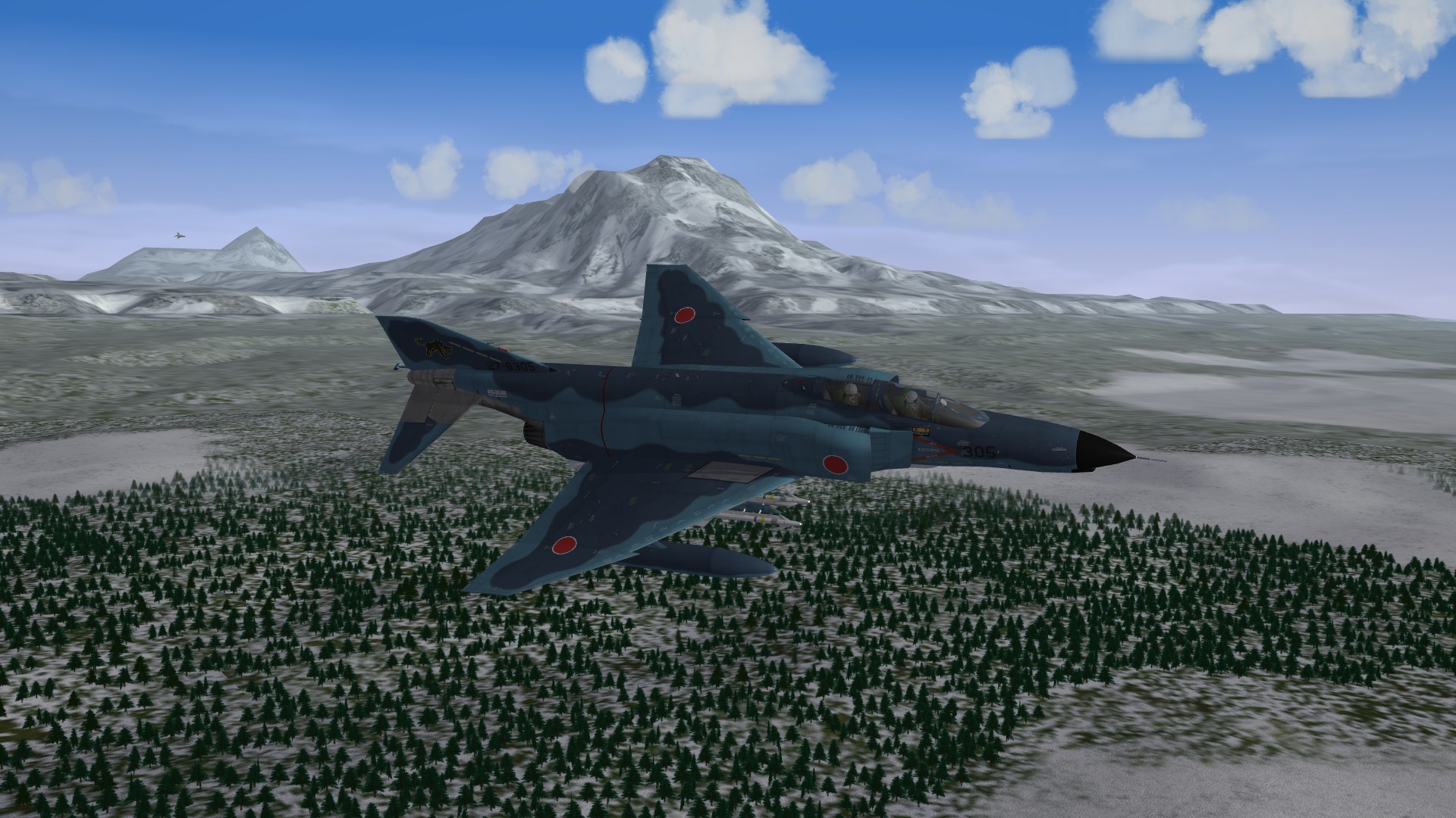
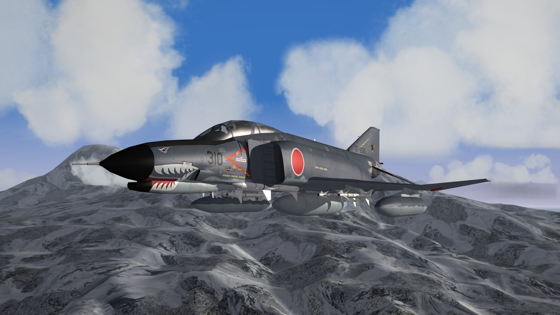
Some shots of TK's JASDF Phantoms over the upcoming Kamchatka v2.0, now featuring winter tileset:- Enjoy
-
Version 2.0
1,038 downloads
Kamchatka Peninsula v2.0 by Baltika For Strike Fighters 2 Series This is an upgrade of my original Kamchatka Peninsula Terrain to bring it up to the latest SF2 standard (September 2011 patch). I was motivated to bring it up to speed to provide a native combat environment for TK's excellent JASDF Phantom F-4EJ, available at the Thirdwire DLC Store. What's new over version 1.0: -Fully compatible with SF2 -Winter and Summer tilesets -Fully operational in Thirdwire Mission Editor (Cheers Crusader!) This terrain includes a base tileset by Deuces, together with Stary's forests and farms mod adapted for use on this terrain. I have also created a large number of additional transition tiles based on Deuce's tiles, which may be of interest to terrain builders. This version 2.0 release also includes a full winter tileset, which is based on Major Lee's DBS terrain tileset. Thanks also to Wrench for creating the water effect .TGA tiles used here which bring the water to life. The tile naming format is compatible with the stock GermanyCE tileset for ease of expansion, but be aware that the excellent hi-res and seasoned tilesets by Brain32 and Stary in particular will not have all the necessary transition tiles, so use them with caution. Should you wish to use the included transitioned tileset for your own terrain mods, copy all the terrain .bmp files and .tga files into the "Tileset" folder and convert the .tga tiles to .bmp format. See Gepard's excellent terrain tutorials in the KB at CA for more info. All mission types are activated, for both red and blue side flyable. The Americans have their existing bases on the Aleutian Islands. I have handed the northern Kuril Islands to the Japanese for the sake of this scenario. Take it as read that the Soviets were sufficiently distracted by the ground war in central Europe that they lost their hold on the Kurils to Japan. Now, the Soviets are engaged in a fierce battle for control of the strategically important Kamchatka Peninsula. This is a target-rich, fictionalised version of the RUssian Far East. There are many installations and industrial zones in the Kamchatkai Krai that you will not find in real life. Equally, as much real-life stuff as I could discover went into the mix. Also, this is a showcase of a fully-transitioned tileset, so there is much more agriculture than you would get at these latitudes. Just kick back and enjoy the scenery. Finally, there is a monstrous presence lurking at the heart of the Peninsula who has risen from aeons of deathless sleep to trouble the affairs of men once more. Bragging rights to the first person to take a recon photo of this horror and make it back to base alive, and with their sanity intact ;-) INSTALLATION:- Simply unzip and drop the "KAMCHATKA" folder into your User\Saved Games\Thirdwire\StrikeFighters2\Terrains folder. It is highly recommended that you install the files listed below or you will not get the full intended Kamchatka Krai experience. RECOMMENDED FILES:- Groundobjects:- CVN-75 by Digital Overload http://forum.combatace.com/index.php?app=downloads&showfile=9684 TAKR Orjol by Gepard http://forum.combatace.com/index.php?app=downloads&showfile=5497 TAKR Admiral Gorshkov by X-RAY http://forum.combatace.com/index.php?app=downloads&showfile=5830 UdaloyI by China Insky Team http://forum.combatace.com/index.php?app=downloads&showfile=10336 UdaloyII by China Insky Team http://forum.combatace.com/index.php?app=downloads&showfile=10330 BRDM_SA-9 by rebelryder http://forum.combatace.com/index.php?app=downloads&showfile=7740 SA-11 & SA-17 by 101tfs http://forum.combatace.com/index.php?app=downloads&showfile=7627 ScudLauncher & Missile by bigal1 http://forum.combatace.com/index.php?app=downloads&showfile=6435 Soviet SAMs by gabilon http://forum.combatace.com/index.php?app=downloads&showfile=3057 CREDITS:- Core tilesets by Deuces and Major Lee. Additional transition tiles by Baltika Winter Sea .TGA tiles by Wrench Forests and Farms mod by Stary, extended to cover additional tiles Kamchatka_water.bmp by Crusader Doppler Radar Dome by grumpapotamus I have modded this as a terrain object rather than a separate ground object. The original readme file is included. Thanks grumpapotamus ;-) WW2 Subpens from WW2 Europe Terrain by Edward et al, modded for Soviet use. Thanks to the original creator. As ever, feedback, comments, bug-reports and general griping are most welcome. Slainthe! Baltika September 2011 -
Slainthe :drinks:
-
Swedish Campaign (The Scandinavian Front)
Baltika replied to JonathanRL's topic in Mission & Campaign Building Discussion
Hi guys, I have been following all this with keen interest, great work here Jonathan, I have an unreleased WoE 08 level campaign for this terrain on my HDD which is set in 2009. It is more or less set to go, unfortunately apart from the ground war, which is in alpha stage, so if you can wait a bit I can finish that up and send it over to you as a template for your earlier campaign. Slainthe! Baltika -
North Cape Terrain (Beta+) for SF2 by Baltika
Baltika replied to Wrench's topic in File Announcements
Wrench, great work on updating this terrain for SF2, cheers bro If you point out the terrain issues (airfields needing flattening etc) with map co-ordinates I will sort em out. I think I have a slightly advanced beta on my HDD somehwere with some/all of those issues fixed - I certainly seem to remember moving an airfield out of the trees recently. And cheers again for fixing the water tiles - that was a big job I hadn't even considered starting, so once more. -
 Great work Wrench, thanks man, I owe you a pint or three
 -
See post #9 http://combatace.com/topic/66537-terrain-editor-is-seriously-irritating-me/ Then you can edit your HFD in gimp on a pixel by pixel basis, using all the brushes, smoothing tools etc you like. Cheers, Baltika
-
Great sim, often overlooked. I recently upgraded my computer from something which was old even in 2005, and finally got around to trying BoB2WoV. Having a blast I take it you have updated to the latest official version (2.11) and installed the multiskin pack? http://shockwaveproductions.com/forum/viewtopic.php?f=10&t=21865&sid=56b7777d4865e361ddbc0df358959d0d After that, Heinkill's mission mega pack is an absolute must:- http://simhq.com/forum/ubbthreads.php/topics/2996619/Mission_Megapack_for_Battle_of.html#Post2996619 Slainthe! Baltika
-
What ALL-NEW terrain would you like to see?
Baltika replied to Centurion-1's topic in Mods & Skinning Discussion
Hi Centurion, no worries, nothing for you to apologise for, it's just I know from bitter experience how much time it takes to build up a terrain from scratch - there really is no point in duplicating effort here. . . Thanks very much for your offer of help. As you are someone with local knowledge, if you have the time, please try out my existing map and let me know any comments, good or bad, you have on it - one or two folks round here have already given me feedback which will find its way into the next release version, so, try it out, let me know what you think - be honest If you want my vote for a new terrain, I'd say Africa - sounds interesting, and it would be perfect for a full-on new Merc campaign. Sort of, "The Wild Geese" with aeroplanes Any questions you have with TE, fire away, I'll try to answer if I can Slainthe! Baltika -
What ALL-NEW terrain would you like to see?
Baltika replied to Centurion-1's topic in Mods & Skinning Discussion
Hi Centurion, Go ahead with a new Scandinavia by all means, but the ground has been covered here already:- http://combatace.com/files/file/11891-north-cape-terrain/ Here's the planning map:- Yes, it is a beta so far, but it will run just fine in SF2 with a couple of .ini tweaks. All of the main civilian and military airbases in the region shown have been plotted, flattened and tiled, and a fair bit of work has been done on terrain targetisation. There is also a custom tileset based on various existing pre-released sets, tweaked and put together for this region. I have moved over completely to SF2 series for modding now, so sooner or later an updated, dedicated SF2 version of this terrain will appear. But, as I say, don't let me stop you if you fancy a crack at a new terrain based on the region. The more the merrier. If you have any questions re TE, fire away and I'll try to help out. @gepard, Kuril Islands terrain is also in the pipeline for SF2 release. . . Slainthe! Baltika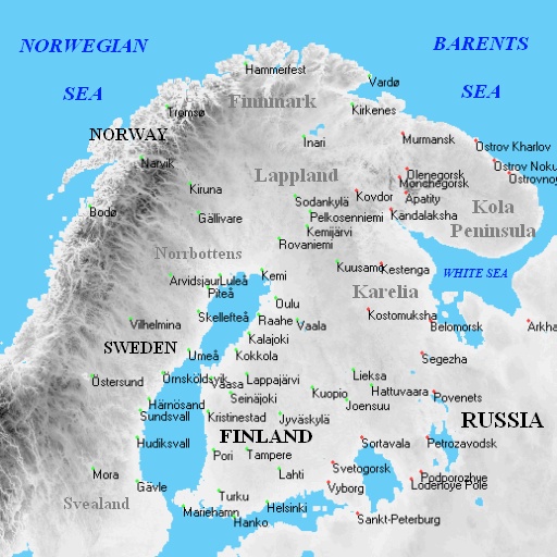
-
Or just look in the appropriate download section here at combatace:- http://combatace.com/files/category/181-p-40/page__sort_by__DESC__sort_key__file_submitted__num__10 Historical Tomahawk skins for the Flying Tigers by yours truly, based on Wrench's templates, with some P-40E skins by starfighters on page 2.
-
Recently took delivery of an Acer Aspire One D255 netbook from my work - not impressed at the spec, Intel atom 1.66GHz, 1GB DDR 3 memroy, a 10.1" screen and a low-grade Intel integrated chip. All on Win7 Starter Edition 32-bit. Was thinking the office had a cunning plan to make me actually do some work But, hey, a bit of fiddling and I find it runs the following rather well, more or less out of the box:- DI Apache Longbow (D3D renderer) F-22 Total Air War 2.0 EF2000 v2.0 (Win 95 install) Janes Fighters Anthology (use script to disable explorer, runs like a champ) Comanche 4 (good for playing with mouse and keyboard on the train) Those old low-res sims actually look and play pretty well on a 1024x600 10.1" screen. Thank goodness, I was worried I might have to do some work Plus, got Starcraft, Diablo II, Half Life, AvP (original 1999 release), Dark Forces 2: Jedi Knight, Battlezone 1.5 and GTA3 for light entertainment. Hail the netbook for retro gaming
-
Tons of stuff in the SFP1/WoX mission and campaign building archives. No doubt, use with caution for SF2, but the series is evolutionary, so it tends to be that more variables are added with each release/update. Extract the stock campaign_data.ini files with each new game and run through to see what new flags are defined. http://combatace.com/topic/31321-how-do-you-make-a-red-flyable-campaign/page__hl__baltika http://combatace.com/topic/33483-setting-aircraft-types/page__p__208580__hl__baltika__fromsearch__1#entry208580 http://combatace.com/topic/27549-question-about-strategic-nodes/page__p__152332__hl__baltika__fromsearch__1#entry152332 http://combatace.com/topic/20489-ground-units-in-campaigns/page__p__88545__hl__baltika__fromsearch__1#entry88545 And at TW:- http://bbs.thirdwire.com/phpBB3w/viewtopic.php?t=5218 Enjoy!
-
Hi Beach, I think you will be pleasantly surprised at the amount of detail you can cram into an SF2 campaign. The engine does all of the things you describe in your post above, keeping track of all ground units and air units for the life of the campaign, their supply levels (both material and equipment) and locations (air units on airbases, ground units on the various strategic nodes defined in your campaign_data.ini file). The frontline is truly dynamic, and airbases and nodes can change hands as combat ebbs and flows. Player success in missions is factored in. If you overfly an enemy airbase and find his Migs lined up on the ground, take them out, as those assets will be lost to that unit and will have to be replaced when the overall supply level allows. Enemy air activity noticeably drops if you wipe out a unit's air assets on the ground. Likewise, player success or failure in CAS missions will usually determine the outcome of a ground assault/defence - although not always, the relative strengths of the ground units and their respective equipment types also come into play. As a rule of thumb, don't lay off knocking out enemy tanks just because the tower calls a mission success - again, ground unit strength is recorded, so, the more tanks you take out in each sortie, the weaker that enemy unit will be in future campaign missions. This is true even if you get a mission fail. The campaign engine tracks supply at FORCE and unit level. Likewise morale. If you knock out enemy trucks in Armed Recon, supply levels for the enemy Force drop. Replacement equipment (planes, tanks) and pilots are determined by overall and unit supply levels. Unit sorties are determined by supply and morale for both ground and air units, although the player unit always flies, for obvious reasons. Your unit can be retired if losses are too great. The post I directed you to over at TW makes it clear that the campaign groundwar is divided into phases. An offensive phase only begins when the overall force supply level is greater than the SupplyForOffensive= value. Whether a frontline ground unit actually makes an attack is determined by its own unit supply and morale values. I have found that tweaking supply and morale levels, especially of ground units, can force historical outcomes regardless of player success or otherwise. I have an old SFP1 WW2 Burma campaign posted here where the Allies will be overrun, no matter how many Allied missions you succeed in. Likewise, you can set things up so player success or loss will determine the outcome - as most of the stock campaigns do. Also, you can rotate air units in and out of service (this was added in WoV). You can set equipment upgrades for long campaigns, so you start flying one type and upgrade, dependent on supply levels. You can also specify "Known Aces" for player and AI air units, then fight them in air combat, or fly as their wingman - that was added for the WW1 First Eagles, but the code has been implemented across SF1 & SF2. If it all seems rather vague, it's because all of these variables seem to be tweaked in the campaign.dll which is hard-coded and unlockable, but which also seems to be adjusted by TK with each patch/upgrade of the core engine. One of the most interesting things for me in each new release (full game, EP or whatever) is to look at the new stock campaign_data.ini files to see what new flags have been added, and to try to work out what those new variables do. As is always the way, we learn by doing. In short, my view is that TK's dynamic campaign engine is vastly under-rated, but then as I started out modding by tweaking campaign files and have done a stack of historical and fictional campaigns over the years, I am probably biased Like malibu says, fire away with any questions and we'll do our best to help out. Slainte! Baltika
-
Quite a bit of detailed info re supply variables here, from TK:- http://bbs.thirdwire.com/phpBB3w/viewtopic.php?f=14&t=5089
-
Get your Kamchatka terrain right here:- http://combatace.com/files/file/10530-kamchatka-peninsula-v-10/ Your JASDF birds will feel right at home With a couple of .ini edits it will run just fine in SF2.
-
Campaign Success trigger?
Baltika replied to gerwin's topic in Mission & Campaign Building Discussion
You can create a custom set of campaign waypoints on the sea for your ship to ship ground war. Do that by adding a set of new target areas in the terrain TARGETS.ini file. They don't need to have any groundobjects placed there, you just need them to use as strategic nodes in your campaign data.ini file. You can specify a unique frontline and campaign strategic nodes for each campaign in the campaign_data.ini. Use the existing base areas as your base nodes, and link them with a join-the-dots network of waypoint target areas for your sea war. Then, use the BasePoint= flag to make sure your ground units show up in the right place. It works like this:- [strategicNode023] Area=NIKOLSKOYE ConnectTo[001].Target=SEVERNOYE ConnectTo[002].Target=PREOBRAZHENSKOYE ConnectTo[002].BasePoint=1053745,638624 [strategicNode024] Area=PREOBRAZHENSKOYE ConnectTo[001].Target=NIKOLSKOYE ConnectTo[001].BasePoint=962103,683374 ConnectTo[002].Target=ATTU ISLAND ConnectTo[002].BasePoint=1364375,454487 [strategicNode025] Area=ATTU ISLAND LocalObjective=TRUE ConnectTo[001].Target=PREOBRAZHENSKOYE ConnectTo[001].BasePoint=1058743,634624 Where the basepoint is the location on your map that the ground battle for the corresponding node will take place. That way, you can keep your ground battles on land or water, for whatever type of ground unit you are using. Obviously, you need separate strings of basenodes for sea and land units, so you don't get tanks showing up at sea or vice versa. For a waterworld type scenario, equip your sea units with the stock patrol boat. That way, you won't need to create new formations for capital ships, as patrol boats are small enough to use the existing tank formations, and lots of small boats zipping around shooting at each other would provide quite an interesting backdrop. -
Campaign Success trigger?
Baltika replied to gerwin's topic in Mission & Campaign Building Discussion
Why not create ship to ship ground war? How to do it can be seen in Midway campaign available here at CA in SFP1 d/l campaign section. Cheers, baltika -
Good work
-
Terrain Editor is Seriously Irritating Me...
Baltika replied to a topic in Mods & Skinning Discussion
Hmmm. . . what I did was use the huge areas generated by TE as my core HM_bmp. Then, I used the scale function in gimp to stretch that bmp so that the piece I wanted was as close as possible to an accurate projection. This is more of an art form than anything else - using easily recognisable, usually coastal features on the terrain bmp to estimate an accurate distance, bearing in mind 2 pixels = 1km in TE, but that TE creates terrains which are 66% of full scale. I tended to use GE to roll the globe to find an accurate projection of what I wanted to map, and work from there, by eye. So, scale up your initial bmp by 4/3 (or 133%) to get a roughly full-scale map. The stretch it out a bit in the x or y axis so that your distances are as close as you can make them, to make allowances for squahing in the north-south axis the nearer you are to the poles. You will get huge bmp files in this process. Once you are happy, with your basic edited projection, use the box selection tool to select an area of pixels on your edited map which is 2000x2000 pixels, or whatever size you want. Then cut and paste that selection as a new bmp image, and save it as whatever you want. Then, using that example, open up TE and create a new terrain, size 1000x1000km, and simply import your new bmp into it to create the HFD, bearing in mind you need tpo set the import and export heightmap numbers in Terraineditor.ini for your edited bmp, so that peak heights are imported correctly to the new map. I've never seen the y-flip thing, I'm not sure what's going on there In TE, there is an Edit/Rotate Map/Flip vertical or flip horizontal setting, maybe you have that checked by mistake? -
Terrain Editor is Seriously Irritating Me...
Baltika replied to a topic in Mods & Skinning Discussion
Depends what you want to do, and how TE handles the initial DEM data, which depends on how near the poles your chosen bit of terrain is. For Moroccoo terrain in the WoA mod, I imported the DEM data for the region and used the .HFD file as created by TE, albeit I had bumped up the height setting in TE to 120%, cos I like big jaggy peaks in mountainous regions, at the expense of sacrificing accurate peak heights. All tiling work was done in TE. Also, the region is close to the equator, so there is very limited north/south compression in the DEM data. But, for that terrain, I was happy for 66% of RL scale which TE creates, as it was a job to be done in a limited timescale. The straits of Gibraltar are a bit narrow, but, hey. . . OTOH, for Iceland terrain, I had to edit the .HFD right off the bat because Iceland is so far north the DEM data is compressed in the North/South axis. So, my editable bitmap had to be stretched in the North/South Axis, and the whole thing had to be scaled up to close to 100%. I also wanted to have an editable bitmap to hand-flatten a lot of airbases as the TE airfield flatten tool is too unwieldy for those narrow fjords. You need to select as large an area for the core terrain as will cover everything you want on your final map. Simply enter a big enough map and pick your Lat/long co-ords in TE. Plenty of room round the edges is good at this stage. Then, from the TE dropdown, use File/Export Heightmap as bitmap. Save it somewhere safe, call it what you want, eg ICELAND_HM_BASE.bmp NB this procedure will chop off mountain peaks unless you have set the import/export heightmap setting properly in the TerrainEditor.ini file. To set it, create your map in TE using the DEM data. Float the cursor over the hightest peak on your map to get the max peak height in meters. Add a hundred meters or so for safety, then divide that peak height by 256. This number is the number you should set in the TerrainEditor.ini file, here:- [bitmapExport] HeightScale=16 [bitmapImport] HeightScale=16 This is from Kamchatka terrain, 16x256=4096m max peak height. Again, I have bumped up the peak heights from RL to give agood craggy, mountain effect. Sure looks good in game, IMHO. If the import/export numbers are different, TE will adjust the scale of heights in your map each time you import/export the heightfield bmp, which will wreck your map. You will lose low-level detail at higher numbers, as TE can only handle 256 height "steps." My preference is for big jaggy mountains at the expense of RL peak heights, and I don't mind losing a bit of low-level detail. Also, I never, ever use the TE "smooth terrain" function as it rounds everything out and makes it bland, smooth and crops off a good bit of height. I edit heights manually, like this:- My imaging software of choice is gimp, for reasons which will become clear. Using gimp, open up your _HM.bmp. You will see the standard blue/green/orange TE heightmap pallette. In gimp, select Colour/Map/Set Colourmap. The script-fu "Set Colourmap" box will come up. In that box, click on the Pallette: button (it shows default, click where it says default). That will bring up the script-fu "pallette selection" box, which showes a list of installed pallettes. Scroll down that list until you come to "topographic." Click on topographic. Close the pallette box, then click on "OK" in the script-fu "Set colormap" box. You will see that the green/blue/orange image has changed to something which is black for sea, with varying shades of blue for land, right up through pale blue, green, then greenish-yellow to white for high peaks. This is a much more visible colourmap for editing heights which shows a clear variation between height steps, unlike the TE standard pallette. Next, check along the top of the gimp box showing your map. This should have the name of your _HM.bmp, and show the colour mode it is in. This should read "indexed, 1 layer." TE cannot read bmps which are in RGB mode, so if your image is not in the right mode, use the Image/Mode/Indexed dropdown to fix this. Save your re-coloured _HM.bmp using "save as" In the dialog, make sure "run length-encoded" is unticked. The acid test comes when you re-import the re-coloured image to TE. TE can only read bmps which are in the correct colour mode, and which are the same size as the map currently set in TE. This last point is really important. If you change the overall size of your HM.bmp by cutting or stretching, then saving it, you have to make sure that TE is set up to accept a map of the new size. So, say I start with a terrain map of 500x500km in TE. When I export the HM bitmap, I get an image which is 1000x1000 pixels. If I stretch my bmp to 2000x2000 pixels, I need to start a new map in TE which is 1000x1000km, and import my 2000x2000 pixel image into that. For Iceland, I stretched the exported bmp more in the north-south axis than east west, to get a proper projection of iceland, compensating for the error in the DEM data at that latitude. Then I cut a piece out of my stretched .bmp file which had everything I wanted on the map, making an allowance for "the wall" at the edge, and saved that as ICELAND_HM_EDITED.bmp. Them I created a new map in TE which was the correct size for the edited file, and imported the HM_EDITED.bmp into the new TE map. That sounds more complicated than it is. Bear in mind that your edited .bmp has to be square, has to be in the right colour mode, and that TE will only read a .bmp when you have set the km size of your map in TE to match the new bmp first. NB 1km in TE = 2 pixels in bmp. You cannot create a 1000x1000km map in TE, export the height bmp, double the size of the bmp, then re-import it to the same session of TE. You have to open a new TE window, set the km size of the new map to match your edited bmp, then import the bmp into the new iteration of TE. You can then edit your topographic image to your heart's content. Bear in mind that if you use the "level airfield" function in TE, you will need to export the heightfield.bmp from TE to save those changes, over-writing your working bmp file. Obviously, I keep a stack of backup heightfield bmps at every stage in case something goes wrong. Sorry, I don't use Photoshop for this, you're on your own there. Likewise, I have done all my hand-tiling in TE, so I can't help with the "export .TFD as bitmap" function. Hope that helps. Cheers, baltika
