PureBlue
-
Posts
1,437 -
Joined
-
Last visited
-
Days Won
5
Content Type
Profiles
Forums
Gallery
Downloads
Store
Everything posted by PureBlue
-
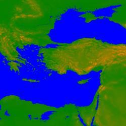
Hello Baltika, As you know TE uses 8bit height data which means there will be 256 different height levels. I think the HeightScale variables in the TerrainEditor.ini governs the highest peak you can have. Like me, you are most likely using the export/import bitmap function for the height map a lot, for airfield leveling and general geogprahical fiddling. The HeightScale=10 default value under both BitmapImport and BitmapExport will effect your map immensely. It will chop the peaks of your mountains . I found about it last night, after searching the thirdwire forums. Quoting TK: [link] The HeightScale= variableunder BitmapExport sets the height step for each index. You'll probably want to adjust this to better match your map, you want the max height in the map to be around 256 (so the HeightScale= max height / 256). Try HeightScale=10, that should cover terrain up to 2560 m in height, if you see peaks getting clippped, you can bump that up. I was having a max height of 2560m for the Anatolian Plateau which is very mountainous. So it looked like flat lands. This means I had to use a value of HeightScale=20 to get the highest peak in the region, at 5120m. Ararat / Ağrı Dağı towers over the eastern Anatolia , which is said to be where Noah's Ark landed...

-
Great improvement Baltika! Cliff tiles has given the terrain some depth, and the dark cold feeling is nicely portrayed. Keep up the good work
-
Good work ordway I been looking tho, there isnt an F-102 available right? Seems like the one we have, Delta Dart is pretty much an improved version of it (just now reading up on both) So its all cool.. edit: well ok Mike clarified it for me
-
This is an excellent package. The briefings and maps, coupled with information from Falklands War webpage and a few books, the whole conflict can be relived. I just flew the beginning 2 missions, and both the Argentine QRA scramble and the Black Buck Raid was a blast. Adrenaline pumping all the way! It's not too easy and it's not impossible but very challanging.. The AI actions are sometimes incredible and sometimes just plain dumb, depends on the situation, I just wish they had a few more variables defined and IF/then/else code inserted to their decision making routines.. In any case, Falklands terrain/campaign is wonderful, full of original objects and towns, and this mission pack just completes it. (only the first day actually So thank you comrpnt, and kesselbrut&co.
-
Thanks Wrench, looks crisp and mean ;) Can I get the anti-collision strips to glow at night? Turn-on and off with the lights.. or is it something to fix from the skin, there are a few planes that need this.
-
SFP Series
-
-
From the album: SFP Series
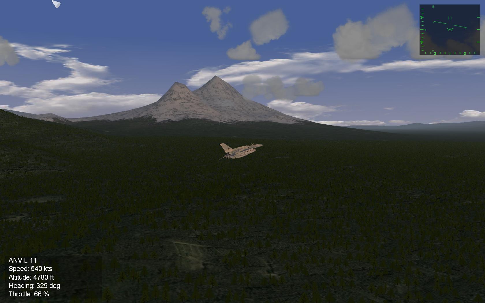
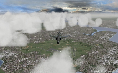
Patrolling over Cigli Airfield, Izmir. -
From the album: SFP Series
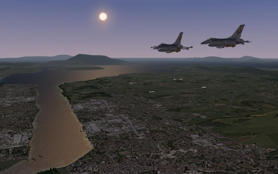
A rhino over Yesilkoy. -
From the album: SFP Series
-
You guys rock!! Thanks a lot Daniel and all contributors!
-
It's such a joy to fly, i'm loving it. Thanks a lot Kreelin and co.
-
try the folder and filenames without the space, maybe thats whats messing it up. edit: wait you tried that already?!
-
It comes with the Gripen.
-
Hey that glacier-lava rock tiles are not too shabby at all! The whole thing is definetly a patience tester, but hang in there. Oh and how in the world I missed those txt files TE created Off to try my luck on some manual height bitmap editing.
-
Good start Baltika, I like the variable landscape and hope you can cook up some tiles for it. The thing I want to ask is, (also messing around with terrain building here), the peaks.txt and sectorheight.txt. Are these used with TE? or perhaps sfmap, which i'm still trying to figure out how to use. Similar to Iceland, Anatolian landscape is very mountainous at places and the DEMs didnt give me specific peaks. so a bitmap export/import, modification phase will be a must. keep up the good work
-
edit: missed the last message and suggested the same thing
-
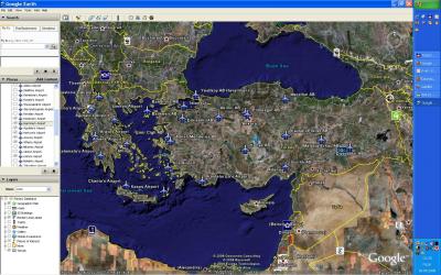
 Thanks to Gepard's article, its very easy to get started on a terrain/campaign project, but much time needs to be spent afterwards, planning and relaying the targets, tiles and all that, plus ofcourse tens of times of rebuilding from scratch - after figuring something new Right now I'm just exploring the modding side of the TK series, its as much fun as flying. I tried to get the whole Turkish borders and quite a few neighbors involved, it came out as a 1800km map! Put in some airfields with targets here and there. After lots of editing, head scracthing, coffee and smokes I get to fly over familiar territory, taking off of real airbases in my country with a F-4E 2020 Terminator that I have been working on.. Fun Stuff! I'll definetly be willing to contribute some airfield/city/target/etc work. The map I have currently is probably way too big.. Just a good discovery journey for me, dont know what it will turn out to be
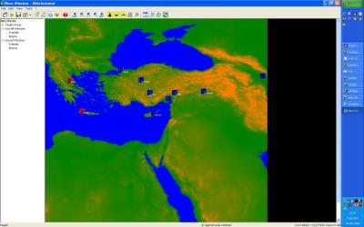
-
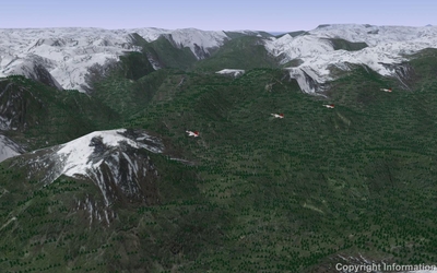
This is 1200km wide. Still the wall problems for the west side. Probably have to combine 4 des files to extend out.. havent tried. Got the TuAF Jet Bases, the Greek ones are not all correct. Had them all too, forgot to save :D Anatolian landscape is very rough, mountains and hills, also ofcourse tidal waves..
-
Read please. "will be all up soon for d\l..." Thanks Russo
-
Rename the first file, old_weapondata.ini then import/merge it onto the one that comes with MF.
-
It all works fine here. Dont forget the CockpitDataFile=Mig*_cockpit.ini definition inside the data.ini
-
Everytime I visit the battlefields in Gallipoli, I feel very emotional. It's like all the hills and trenches are full of stories of the big struggle. I salute all the men that fought there.
-
No, you hit an invisible wall before even reaching the edge of the map. I hope the Syberian map can be used by the sfp engine, its colossal in size.
-
Good story Stick. So the Mig didnt try to kill you, he ran? Chicken AI
-
Otc Will Be Update 10 Jan 07
PureBlue replied to Dave's topic in Mission/Campaign Building Discussion
Yes it is a BLAST!! I just started campaigning it yesterday, First time out , tasked to bomb a missile site SW of the island, flying lead to 8 F-100D's. At about half way, hooked up with our Migcap Phantoms from USS Coral Sea! Just about 10 miles out all hell breaks loose. The flak and explosions were so loud, I kept jumping in my seat, gave my orders to the flight, dumped my bombs in a hurry and just ran my ass out of there. jinking crazy with sams and migs all around... oh man it was so exciting! Great job guys, top notch menus, beautiful grafix, lots of fun. Thank you OTC team!