Gepard
-
Posts
6,958 -
Joined
-
Last visited
-
Days Won
347
Content Type
Profiles
Forums
Gallery
Downloads
Store
Everything posted by Gepard
-
It very sad to see how big parts of Australia become victim of mega size forest fires. Its very sad. But always if i see the pictures i ask myself, wheter the firefighters do their job properly. I remember a day during my military duty time in East Germany. It happend during a shooting training in summer. It was hot and dry. One burst of tracer ammo missed the target and caused a fire. In astonishingly short time the fire became bigger and bigger and went out of control. Me and my comrades were orderd to fight the fire at all costs, with all what we had. And to be honest, we had not very much, only our small military spades, which we called Muckerlöffel or UB-1 which stand ironically for Universalbagger (universal excavator). We shoveling the hole day and we had no chance against the fire. The forest was lost. That all guys thought. No chance. But then, we heared tank engines and short afterwards 3 pionier tanks T-55TK arrived the area. Each tank was equipped with a dozer plate. The tankers said to us: "Nice try, but now look how the profis make it the right way." The drove back some hundred meters and started to make a path (glade) mid in the forest. It needed some time, but when they finished in the forest was a deep scar of pure soil, no tree, no plant, a scar as wide as a german Autobahn. Then the boss of the tankers came to us and asked who of us had match packages. Of course all of us had matches, because lighters were rare in East Germany. Then the officers stuck his finger in his mouth, checked from which direction the wind came, and then he gave us the order enemyward ( word by wort translation of "Feindwärts", what means the direction, where the enemy is, comarable with starboard and backbord on ships) of the paved glad to light small fires. We should make two steps, then light the gras, make two steps, light the gras and so on and so on. We started to burn down the forest, but in a controlled and slow way. Our "counter fire" had to crawl against the wind, so that it not was able to become big and fast. When the big, hot and fast forets fire reached the "defence line", our small fire had "eaten" all trees and plants, so that the big fire had no food anymore and broke down in a astonishingly short time. Mid next day the fire was out. We sacrificed a smaller part of forest to save the much bigger part. We fought fire with fire. And we won. In this summer in Germany was also a big forest fire which the firefighters were unable to handle. The smoke was to smell 500 km away. After some days, when the civil authorities acknoledged, that they were unable to stop the fire they asked the Bundeswehr for help. 2 or 3 days later the Bundeswehr pionier tanks started to fight the forest fire in the same way like in my military time. After 3 days the forest fire was defeated. Perhaps the Aussis should do it in the same way. Fight fire with fire. Edit. I forgot to post a picture of the east german pionier tanks. T-55TK. Its a very helpfull beast.
-
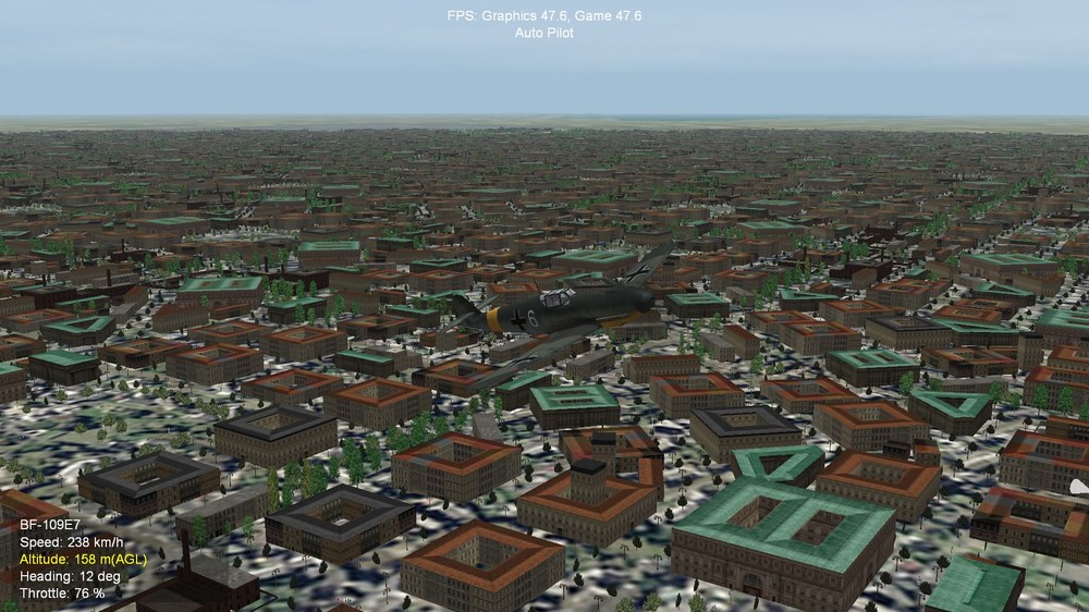
The screenshots are from which game (SF2 or WOX). And which terrain is it?
-
Which tileset do you use now? Can you post a screenshot? I have seen, that at least one or two new tiles still must created, for rivermouth into the sea and a riverfork.
-
The terrain is made with 500x500m tiles to get a better look in FE. For SF2 tiles with 2000x2000m are needed. So it is not usable for SF2. To make it work in SF2 a complete new retiling of the terrain is neccessary. I download your files in this moment. I will check them out. Edit: I have installed your files and on my computer the terrain runs fine. Perhaps the tileset neeeds to much ressources for your computer. You could try to replace it with a more simple tileset or the stock tileset from FE.

-
Post the ostpreussen.hdf, the ostpreussen.tdf and the ostpreussen_data.ini files here. I will check it out.
-
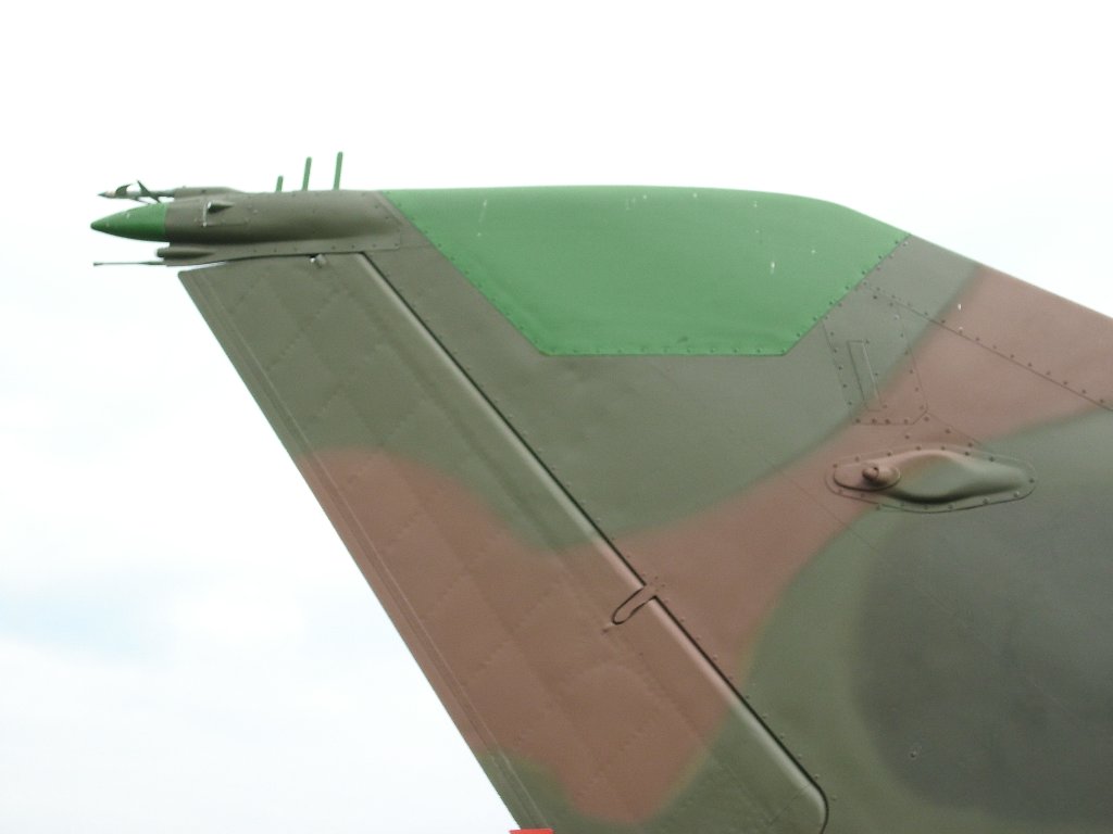
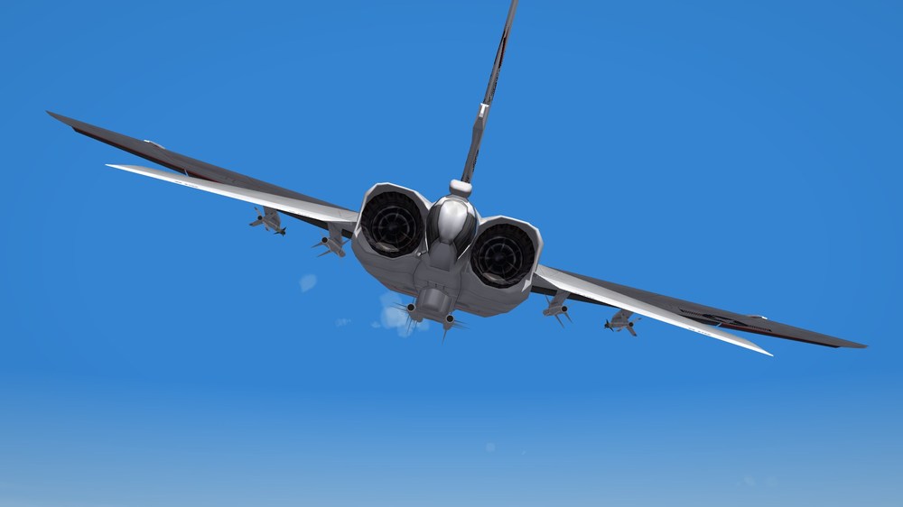
The antenna which is formed like the tip of an hunting arrow is the so called SAU antenna. SAU is a automatically landing approach system, which enables the plane to perfom an autonomous landing approach or on more modern systems an autonomous landing of the plane. SAU is part of the RSBN navigation system. RSBN is comparable with the american TACAN, but is much more precise. Normally you has two such antennas on the plane. One under the nose, the other on the tailfin. Here the SAU antenna on the tailfin of the MiG-21bisSAU

-
This happens only in this terrain? If yes, than it could be that a corrupted Ostpreussen_data.ini cause that problem. What editor do you have used? Could it be, that you tried TK's TerrainEditor? This editor has negative influence on file Ostpreussen_data.ini. If you use the TerrainEditor you must make a backup of the *_data.ini file and after editing you must use the backup file. To solve this problem you can take the Ostpreussen_data.ini file from my here posted Ostpreussen.zip as backup. There is one rule for terrain making: make backups! If something goes wrong you can go one step backward and try it again.
-
What exactly does not work? The entire terrain after your changes?
-
I think the line: NationName=GENERIC should work properly.
-
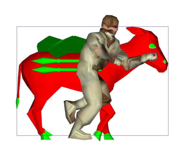
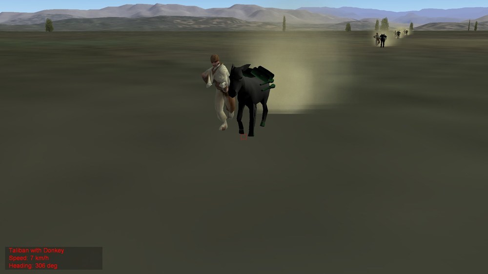
For my old Afghanistan terrain i made a Muli with a Taliban. Its old and was made for WOE, but better then nothing. Here a screen frm LOD viewer. In game the muli is grey. TalibanEseltreiber.7z Unzip in your groundobjects folder. It will appeare in Armed_recon mission as target in columns, like the Trucks. edit: ingame screenshot from Afghanistan terrain.
-
Cool skin!!!
-
Retaliator. Nice idea.


-
Looks like a North American project NR-349 Retaliator, but without third engine.
-
Someone had a E-152 as WIP. Cant remember who.
-
There is the possibility to change the callsigns of the flights. Its in one of the ini files of the flight folder.
-
Perhaps ShipSmoke? Its a stock effect.
-
Sorry, my fault. You are right, it would be perfect for 1939 and 1944/45.
-
There i cant help you. I have never heared, that a physical map can used in TFD tool. I use maps from my old school Atlas ord historical maps from net. The placement of target areas are more or less a guess. Orientation points can be structures in the HFD file which can identified, like rivers, coastlines, mountains.
-
Do you have an idea where we can find this map? To use it would make a soviet-polish war scenario so much easier.
-
To be honest, the river is to narrow. The Weichsel/Visla is close to the Baltic a big river. But i think it is not a problem. Use the standard tile, its good enough.
-
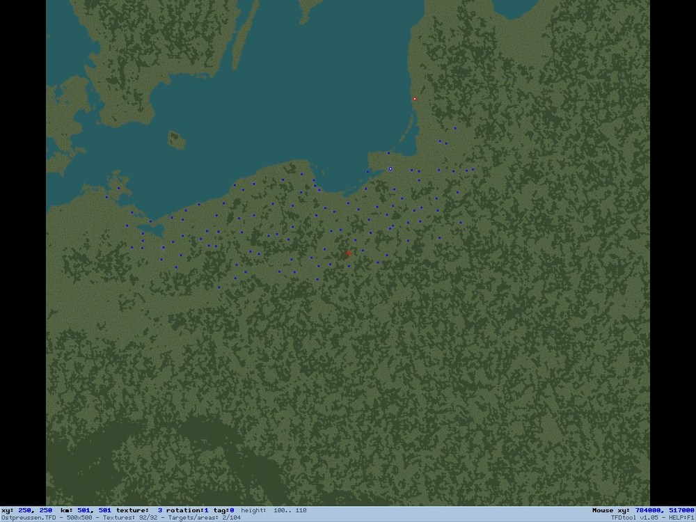
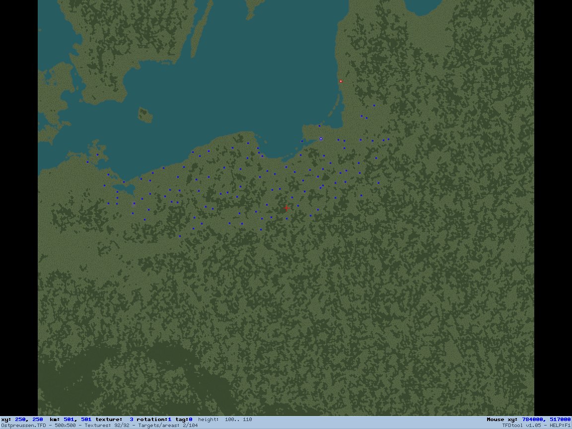
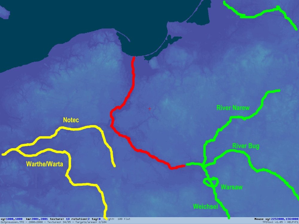
It is the correct way to follow the height path of the river. You can fix the heigh datas if they are wrong with TDF editor. The path of the river Weichsel/Wisla/Visla/Vistula/ Ви́сла is correct for the lower reaches of the river (without the Weichseldelta). But in the area you need for a soviet polish scenario the river is not tiled. The red line show the river as you placed it on the map. The green lines are rivers, which are neccessary to be placed. The green "circle" is the position of Warsaw, the polish capital, which is indispensable. The yellow lines are rivers which would be "nice to have" but not really ne ccessary. As you see, the area, where the battle called " The miracle on the Vistula" was fought is not tiled yet.
-
I check it out. But next time it would be enough if you send the ostpreussen.hdf and the tdf file.
-
On way home you could have visited the Flugplatzmuseum Cottbus or Luftwaffenmuseum Berlin Gatow. Both have nice plane collections.
-
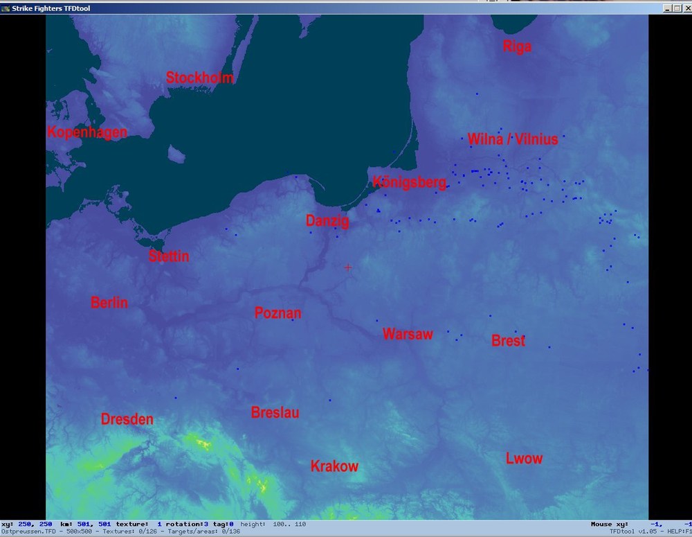
Here is the very early phase terrain which i had called Ostpreussen (East Prussia). It has no airfields, no populated target areas, no rivers, no roads. The tiling is rudimentary. Only 104 towns are placed as simple squares on the map. It need a lot of work to finish it. But if someone want to do the job, feel free to do it. Only one thing: Give me proper credit for the basic files and Jan Tuma for the tileset, which is included in the package. Ostpreussen.7z
-
I have tried to move the terrain from WOE to FE, but it allways crash to desktop. Surely it is only a minor mistake in one of the lines, which i still have to find. Basicly said. The terrain covers the area of the modern Poland, or the old german east areas Pommern, Schlesien, Ost- and Westpreussen and in the middle the old polish republic and the two southern baltic states. The big river in the mid of the terrain is the Weichsel (Wisla if you use the polish name). In the "knee" of this river Warsaw, the polish capital is situated. The outer north east bay is the Bay of Riga, Riga is the latvian capital. So the battle on the Weichsel could be part in a polish soviet scenario. The soviet attacks reached a line approx between Warsaw and Königsberg and Warsaw to Krakow. But all fights east of Brest to Kiev or Minsk are not part of the map. The status of the terrain is very early. auto placement of cities is only done for the german territory and the so called "korridor". All other things still have to done. No rivers layed, no streets, no runways, no populated target areas and so on. The red dot is the town of Memel (Kleipeda), the blue whote dot is Königsberg. Which are airfield for test reasons.