Leaderboard
Popular Content
Showing most liked content on 09/14/2022 in all areas
-
9 points
-
4 pointsHML-167 (top) VMO-6 (bottom) on the prowl for Charlie (revamps of Pasko's UH-1B. coming "soon")
-
3 points
-
2 points
Version 1.0
502 downloads
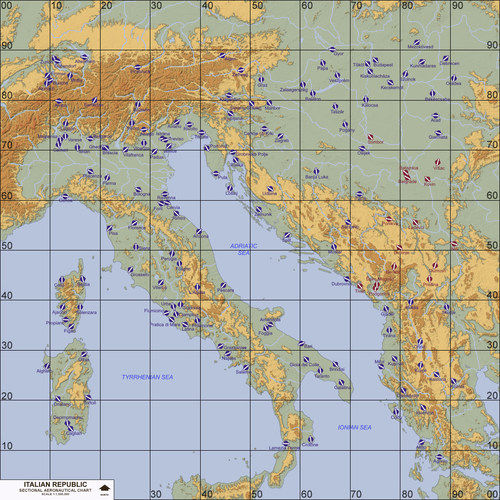
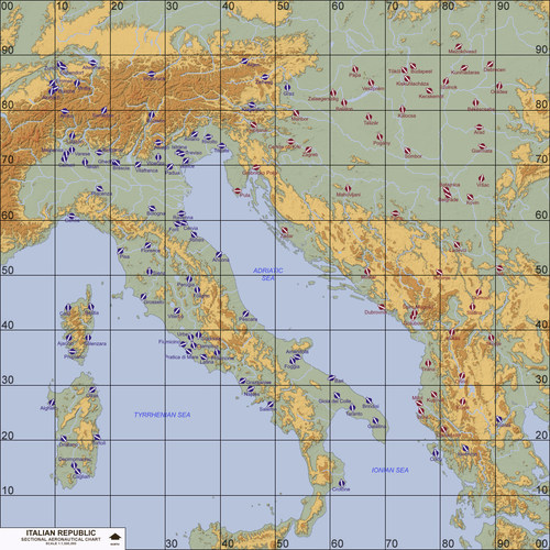
Italy, Southern Europe (1993-2006) Terrain September 13th, 2022 (1st Release) by Menrva and tiopilotos >For Strike Fighters 2, Recommended Full-5 Merged I am very proud to release a long awaited, brand new terrain made from scratch! The result of many years of dedication and sweat starting in 2017, it features thousands of manually placed tiles reproducing Real World river courses and lakes, not to mention tons of cities all accurately placed in their correct locations. This terrain portrays a pretty complex area, no wonder it never got made properly in two decades of Strike Fighters modding. It is my hope you realize the amount of time and hard effort that I have put to reproduce it with much care and detail. The terrain completely covers Italy (with the exception of Sicily, which is included in my Libya terrain), Serbia, Montenegro, Croatia, Slovenia, Bosnia-Herzegovina, Albania, Corsica (France), Liechtenstein and nice portions of Austria, Hungary, Switzerland, Macedonia, Greece and even a bit of Romania. The tileset, based on one of Stary's GermanyCE tilesets, has been recoloured and expanded with needed transition tiles and features beautiful, unique tiles by tiopilotos which reproduce real islands. Expect long and very accurate river courses, all major and some minor lakes, and tons of islands in the Adriatic Sea. Numerous target areas have been added in order to expand playability, targets of opportunity and year range; those include more than 140 airports, more than 100 SAM sites and more than 70 EW-GCI sites, all placed accurately in their correct locations as shown by well-made SAM site datasets for Google Earth. This terrain features a fresh new 250m resolution heightmap (instead of the stock 500m resolution), allowing for greater details and precision in elevation changes; overall it provides the whole terrain with a better look. The terrain spans from April 12, 1993 (the beginning of Operation Deny Flight) to June 2, 2006 (the day before Montenegro declared its independence). This terrain is adapt for the Yugoslav Wars and for what-if scenarios pitting Serbia against NATO. For gameplay purposes, Bosnia is set to Red Side alongside Serbia and Montenegro. Slovenia, Croatia and Macedonia are set to Blue Side. Airfields in Austria, Switzerland and Romania have been set to Neutral, so the AI and the player will never spawn on those by default. Targets reflect Real World events as accurately as possible. Having SF2NA is a must, as I have enabled naval ops; if your mod folder contains American, French and Italian aircraft carriers, sometimes you'll see fleets being generated in single missions. NOTE: The terrain is not fully finished. It currently misses targets for cities, such as bridges, warehouses, factories etc. If time will allow, maybe someday it will be completed properly. >Credits (in no particular order): -tiopilotos, for working on very well done island tiles which offer more unique sights in the Adriatic Sea. -swambast, who provided me with invaluable help in tracking and fixing common and uncommon bugs. -gerwin, whose TFDtool has proved to be essential in today's terrain making. If the terrain is pretty accurate to RL it's also because of him. I included his very nice Airfield 7+8 Addon Pack, too. -mue, for the improved shaders he made, which I have included and reworked for the terrain, and for the tools he made for SF2 modding. -JSF_Aggie, for his Hi-Res Runway Textures package which I have included and slightly reworked. -Coupi, for his Soviet style repaint of the stock Runway3 airfield. -luk1978, for the waternormal bitmap he shared at the SF2 screenshots thread. Your mods are very interesting! -Stary, for an old version of his GermanyCE tileset included in the Anatolia v1 terrain by PureBlue. -Gepard, for his great tutorials about terrain making, in the SF1 Knowledge Base at CombatACE. It's a gold mine! -krfrge, who has produced a tutorial for recreating SF2-like planning maps, which prompted me to work on templates and my own high quality planning maps. Thank you very much! -comrpnt, for his Approach and Airfield Lighting Pack mod packages for SF1 series, which I reworked and included. >Trivia: Some statistics of the amount of work that went into it, gathered thanks to gerwin's TFDtool. I placed manually one by one: more than 8600 rivers tiles, more than 1100 road tiles, more than 2000 city related tiles! This is just the tip of the iceberg, not counting other thousands of tiles that have been placed manually on the tilemap to better reproduce coastlines, islands and lakes, and not counting the endless hours of research since 2017 into adding all possible airports with much accuracy. >Disclaimer: This is a freeware; you are NOT allowed to redistribute it without my prior explicit consent. Any changes to the terrain package's files and/or any copy-and-paste attempts of their contents are NOT authorized if you plan to release them in other mods. But permission might be granted to those who request it to me at CombatACE. This terrain may NOT in any way, shape or form be used in any payware additions. -
2 pointsGreat Terrains @Menrva Fantastic for low flying in the valleys. If you do an update to the 1993 terrain you may want to add some more NATO nations to the Nations.ini to represent the various contributors to Operations Deliberate Force (1995) and Allied Force (1999). I've added these to my install: FriendlyNation010=RAF FriendlyNation011=RoyalNavy FriendlyNation012=WGermany FriendlyNation013=WGermanNavy FriendlyNation014=Belgium FriendlyNation015=Netherlands FriendlyNation016=Denmark FriendlyNation017=Canada FriendlyNation018=Spain FriendlyNation019=Portugal FriendlyNation020=Norway FriendlyNation021=Turkey
-
2 points
-
2 points
-
2 points
-
2 points
-
2 pointsI want to explain that this terrain work of mine is not fully complete as usual. It features all possible airports, air bases, SAM sites and radar sites, alongside extremely accurate topography with Real World river courses and lakes. However, cities are missing targets entirely, things like bridges, warehouses, factories, etc. To develop this terrain has been all but a pleasant journey, it burnt me out numerous times to the point of hating it. Moreover, I've been suffering from an health issue for a year with no clear solution in sight. It has drained most of my energy. If and when I feel better, I'll consider completing the terrain with the addition of targets in cities. I think it's best that I release it as is rather than keeping it wasted on my hard disk. For personal use only, you can modify it as much as you want. I just don't want to see the terrain being modified and/or redistributed here or elsewhere without my prior explicit consent. That's all I ask. The community has dwindled so much in recent years and this terrain comes too late, only very few fans of Strike Fighters will be enjoying it and this sort of demotivates me from doing any further terrain modding. This may well be my last terrain work, it really exhausted me to this point. If you encounter any bugs or oddities, please do not bother me about those. I know well the terrain is not perfect nor complete, but right now I have other priorities alongside my health concerns. Take care, everyone.
-
1 point
Version 1.0
347 downloads
Italy, Southern Europe (1963-1991) Terrain September 13th, 2022 (1st Release) by Menrva and tiopilotos >For Strike Fighters 2, Recommended Full-5 Merged I am very proud to release a long awaited, brand new terrain made from scratch! The result of many years of dedication and sweat starting in 2017, it features thousands of manually placed tiles reproducing Real World river courses and lakes, not to mention tons of cities all accurately placed in their correct locations. This terrain portrays a pretty complex area, no wonder it never got made properly in two decades of Strike Fighters modding. It is my hope you realize the amount of time and hard effort that I have put to reproduce it with much care and detail. The terrain completely covers Italy (with the exception of Sicily, which is included in my Libya terrain), Yugoslavia, Albania, Corsica (France), Liechtenstein and nice portions of Austria, Hungary, Switzerland, Greece and even a bit of Romania. The tileset, based on one of Stary's GermanyCE tilesets, has been recoloured and expanded with needed transition tiles and features beautiful, unique tiles by tiopilotos which reproduce real islands. Expect long and very accurate river courses, all major and some minor lakes, and tons of islands in the Adriatic Sea. Numerous target areas have been added in order to expand playability, targets of opportunity and year range; those include more than 140 airports, more than 100 SAM sites and more than 70 EW-GCI sites, all placed accurately in their correct locations as shown by well-made SAM site datasets for Google Earth. This terrain features a fresh new 250m resolution heightmap (instead of the stock 500m resolution), allowing for greater details and precision in elevation changes; overall it provides the whole terrain with a better look. The terrain spans from April 7, 1963 (the day the Socialist Federal Republic of Yugoslavia was introduced) to June 24, 1991 (the day before Slovenia and Croatia declared independence). This terrain is adapt for Cold War scenarios pitting NATO forces against the combined Red Side forces of Yugoslavia, Albania, Hungary and Romania. Airfields in Austria and Switzerland have been set to Neutral, so the AI and the player will never spawn on those by default. Targets reflect Real World events as accurately as possible. Having SF2NA is a must, as I have enabled naval ops; if your mod folder contains American, French and Italian aircraft carriers, sometimes you'll see fleets being generated in single missions. NOTE: The terrain is not fully finished. It currently misses targets for cities, such as bridges, warehouses, factories etc. If time will allow, maybe someday it will be completed properly. >Credits (in no particular order): -tiopilotos, for working on very well done island tiles which offer more unique sights in the Adriatic Sea. -swambast, who provided me with invaluable help in tracking and fixing common and uncommon bugs. -gerwin, whose TFDtool has proved to be essential in today's terrain making. If the terrain is pretty accurate to RL it's also because of him. I included his very nice Airfield 7+8 Addon Pack, too. -mue, for the improved shaders he made, which I have included and reworked for the terrain, and for the tools he made for SF2 modding. -JSF_Aggie, for his Hi-Res Runway Textures package which I have included and slightly reworked. -Coupi, for his Soviet style repaint of the stock Runway3 airfield. -luk1978, for the waternormal bitmap he shared at the SF2 screenshots thread. Your mods are very interesting! -Stary, for an old version of his GermanyCE tileset included in the Anatolia v1 terrain by PureBlue. -Gepard, for his great tutorials about terrain making, in the SF1 Knowledge Base at CombatACE. It's a gold mine! -krfrge, who has produced a tutorial for recreating SF2-like planning maps, which prompted me to work on templates and my own high quality planning maps. Thank you very much! -comrpnt, for his Approach and Airfield Lighting Pack mod packages for SF1 series, which I reworked and included. >Trivia: Some statistics of the amount of work that went into it, gathered thanks to gerwin's TFDtool. I placed manually one by one: more than 8600 rivers tiles, more than 1100 road tiles, more than 2000 city related tiles! This is just the tip of the iceberg, not counting other thousands of tiles that have been placed manually on the tilemap to better reproduce coastlines, islands and lakes, and not counting the endless hours of research since 2017 into adding all possible airports with much accuracy. >Disclaimer: This is a freeware; you are NOT allowed to redistribute it without my prior explicit consent. Any changes to the terrain package's files and/or any copy-and-paste attempts of their contents are NOT authorized if you plan to release them in other mods. But permission might be granted to those who request it to me at CombatACE. This terrain may NOT in any way, shape or form be used in any payware additions. -
1 pointView File Italy, Southern Europe (1963-1991) Italy, Southern Europe (1963-1991) Terrain September 13th, 2022 (1st Release) by Menrva and tiopilotos >For Strike Fighters 2, Recommended Full-5 Merged I am very proud to release a long awaited, brand new terrain made from scratch! The result of many years of dedication and sweat starting in 2017, it features thousands of manually placed tiles reproducing Real World river courses and lakes, not to mention tons of cities all accurately placed in their correct locations. This terrain portrays a pretty complex area, no wonder it never got made properly in two decades of Strike Fighters modding. It is my hope you realize the amount of time and hard effort that I have put to reproduce it with much care and detail. The terrain completely covers Italy (with the exception of Sicily, which is included in my Libya terrain), Yugoslavia, Albania, Corsica (France), Liechtenstein and nice portions of Austria, Hungary, Switzerland, Greece and even a bit of Romania. The tileset, based on one of Stary's GermanyCE tilesets, has been recoloured and expanded with needed transition tiles and features beautiful, unique tiles by tiopilotos which reproduce real islands. Expect long and very accurate river courses, all major and some minor lakes, and tons of islands in the Adriatic Sea. Numerous target areas have been added in order to expand playability, targets of opportunity and year range; those include more than 140 airports, more than 100 SAM sites and more than 70 EW-GCI sites, all placed accurately in their correct locations as shown by well-made SAM site datasets for Google Earth. This terrain features a fresh new 250m resolution heightmap (instead of the stock 500m resolution), allowing for greater details and precision in elevation changes; overall it provides the whole terrain with a better look. The terrain spans from April 7, 1963 (the day the Socialist Federal Republic of Yugoslavia was introduced) to June 24, 1991 (the day before Slovenia and Croatia declared independence). This terrain is adapt for Cold War scenarios pitting NATO forces against the combined Red Side forces of Yugoslavia, Albania, Hungary and Romania. Airfields in Austria and Switzerland have been set to Neutral, so the AI and the player will never spawn on those by default. Targets reflect Real World events as accurately as possible. Having SF2NA is a must, as I have enabled naval ops; if your mod folder contains American, French and Italian aircraft carriers, sometimes you'll see fleets being generated in single missions. NOTE: The terrain is not fully finished. It currently misses targets for cities, such as bridges, warehouses, factories etc. If time will allow, maybe someday it will be completed properly. >Credits (in no particular order): -tiopilotos, for working on very well done island tiles which offer more unique sights in the Adriatic Sea. -swambast, who provided me with invaluable help in tracking and fixing common and uncommon bugs. -gerwin, whose TFDtool has proved to be essential in today's terrain making. If the terrain is pretty accurate to RL it's also because of him. I included his very nice Airfield 7+8 Addon Pack, too. -mue, for the improved shaders he made, which I have included and reworked for the terrain, and for the tools he made for SF2 modding. -JSF_Aggie, for his Hi-Res Runway Textures package which I have included and slightly reworked. -Coupi, for his Soviet style repaint of the stock Runway3 airfield. -luk1978, for the waternormal bitmap he shared at the SF2 screenshots thread. Your mods are very interesting! -Stary, for an old version of his GermanyCE tileset included in the Anatolia v1 terrain by PureBlue. -Gepard, for his great tutorials about terrain making, in the SF1 Knowledge Base at CombatACE. It's a gold mine! -krfrge, who has produced a tutorial for recreating SF2-like planning maps, which prompted me to work on templates and my own high quality planning maps. Thank you very much! -comrpnt, for his Approach and Airfield Lighting Pack mod packages for SF1 series, which I reworked and included. >Trivia: Some statistics of the amount of work that went into it, gathered thanks to gerwin's TFDtool. I placed manually one by one: more than 8600 rivers tiles, more than 1100 road tiles, more than 2000 city related tiles! This is just the tip of the iceberg, not counting other thousands of tiles that have been placed manually on the tilemap to better reproduce coastlines, islands and lakes, and not counting the endless hours of research since 2017 into adding all possible airports with much accuracy. >Disclaimer: This is a freeware; you are NOT allowed to redistribute it without my prior explicit consent. Any changes to the terrain package's files and/or any copy-and-paste attempts of their contents are NOT authorized if you plan to release them in other mods. But permission might be granted to those who request it to me at CombatACE. This terrain may NOT in any way, shape or form be used in any payware additions. Submitter Menrva Submitted 09/12/2022 Category Full Terrains
-
1 pointUpdated the missile launchers and the missile location for both models, they just need to be a proved.
-
1 point
-
1 point@madvad You're a sniper in catching bugs, I should hire you. Jokes aside, it's your lucky day, it was a rather quick fix. I've re-uploaded the two terrain packages. You'll have to wait until they are re-approved. I won't be available for other bug fixing though. Anything else you people wish to see fixed or improved, send me a PM and I'll care to read it when I feel the time is right. Don't expect immediate support, I need some rest.
-
1 point
-
1 point
-
1 point
-
1 pointAs long as it is for your own use, feel free to do so. Actually, I originally set the year span to 1993-2030, but various Real World changes happened after 2006 (Montenegro got independent, grew closer to the West and later joined NATO; Macedonia got renamed to North Macedonia; Kosovo self-declared its independence, etc.) and those would require a third version of the terrain. To keep things simple and scenarios realistic, I limited the year span to 1993-2006. If you increase it to 2030, you'll see that a couple of airports disappear at given years, because they were either destroyed or abandoned, so I also took into account such events well beyond 2006.
-
1 point
Version 1.0.1
107 downloads
Hello and thank you for downloading my work. https://gkabs.net What's included: Afghan SA-7 site. All my files should include the Strike Fighters 2 Series game file (.old) and the texture required. (tested and work only for SF2) Installation: Copy files to their proper folder If you need any further help please read the Knowledge Base at: https://combatace.com/forums/forum/268-thirdwire-strike-fighters-2-series-knowledge-base/ 1.0.0 LICENSE: You are allowed to use this model and everything included for personal non-profit use for Strike fighters 1 and 2. You need to contact me for permission to use outside of this scope. gkabs@gkabs.net Credit goes to the following: Third Wire for making this outstanding game. Yakarov79 for making the SA-7 launcher and missile models as well as testing. thank you again, my friend Credit goes to https://www.textures.com as I use many of their photos to create the skins. Google for some photos and information. https://www.mixamo.com/ for using their free character making and rigging. And finally not to forget the wonderful site of https://combatace.com and all the nice members and their dedicated support for this game. Software used: 3d Max 2009 UVLayout v2 Pro Substance Painter Adobe Photoshop If you need any assistance please contact me at gkabs@gkabs.net Extra. If you want to have the Afghan show in the mission editor [MissionData] NationName=Afghanistan ServiceStartYear=1970 ServiceEndYear=1995 //GroundObjectRole=AAA <----- GroundObjectRole=MISC <------ Availability=COMMON Exported=TRUE ServiceStartYear=1975 ExportEndYear=2030 ExportAvailability=COMMON -
1 point
-
1 point
-
1 point
-
1 pointCaught a boomer on the surface somewhere off the North Cape. Positively ID'd as a Typhoon... Wow, she's big... Well, she knows she's been spotted, time to head back to the carrier...
-
1 point
-
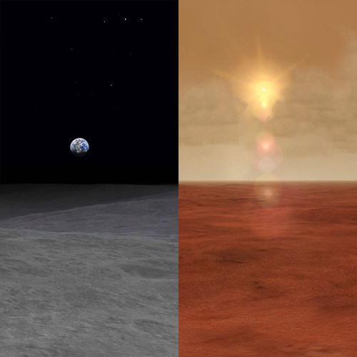
1 pointI think the guy is confusing blur with bloom. I explicitly wrote in my realSKY Readme file that bloom postprocessing is used by the game when Effects settings are set to Unlimited. This is unrelated to the mod, although realSKY provides better postprocessing given engine limitations. I wonder why I waste time writing Readme files. About effects, the best currently available are from Stary's Unified Effects package. For the ODS mod, me and guuruu have been improving those and fixing any mistakes, typos, wrongly referenced shaders, etc. Maybe some day I'll think about re-releasing them as a standalone package. Much better looking effects are simply not possible, the graphics engine is not capable of features like proper heat waves, volumetric clouds, etc. The game is old, live with it. Besides, to be asking for even better freeware mods than the ones already available is a bit insulting and annoying. I almost lost my sanity while working with obsessive care and precision on some add-ons (which are free). There are people spending their free time to make others happier, with absolutely nothing in return. So let's be grateful for what the community already offers. Rant over.
-
1 pointMenrva, special THANK YOU for all your incredible dedication and commitment in bringing these to life...Artistic terrain building is a tough and demanding skill and it always wonderful to see your updates - know that they are appreciated and keep up the great work!
-
1 pointUnfortunately, the images for my SF Series radar tutorial were split between an old anonymous image shack account that is long gone and a registered one that now requires a monthly fee to manage. I have recovered some of the images from the registered account. The original tutorial is intact in Bunyap's old Weapons Delivery Manual, so if that is still around for download, it has the complete text and images in decent text book format. Since the original knowledge base thread is locked, here is a copy with the salvaged images attached via CombatAce upload. Using radar and radar homing missiles like the AIM-7 Sparrow on Hard settings seems too hard for many people. With a little review of the way radar works and what the display indications mean, it really isn't that difficult. A basic summary: 1. Use Search Mode to detect a target on your display (vary the range scale using the <PAGE DOWN> key if necessary). 2. Use the <HOME> key to move the cursor to the target. 3. Use the <INSERT> key to lock on. 4. Center the steering dot in the ASE circle. 5. Launch when "IN RANGE". 6. Maintain target lock on until missile hits, or missile will miss. Note: Once you have locked on, you can use <CTRL><R> to visually acquire the target, which also identifies the type of aircraft (an unrealistically accurate form of IFF). Then use either <F4> to padlock the target from within the cockpit, <SHIFT><F8> to padlock the target from an external player-to-target view, or <F8> to see the target up close. Alternatively, steps 1 through 3 can be bypassed when engaging targets held visually: Select Boresight Mode and hold your gunsight exactly on the target until a lock on occurs. Then continue with step 4. The idea behind radar in the 1960s was that radio energy could be used to search for contacts by rapidly sweeping an antenna from side to side while transmitting radio energy pulses and receiving "echoes" from targets hit by those pulses. The antenna has a "beam", which is the pattern or shape of the radio transmission. Ideally, this beam is very narrow since it determines the elevation and azimuth resolution. The radar display graphs the azimuth (bearing) of the antenna versus the time (range) of the echoes. In the case of the F-4 radar as portrayed in SFP1 and WOV, the elevation of the antenna alternates between a look up and a look down angle. Each elevation angle is referred to as a bar. The F-4 radar's search pattern in SFP1 and WOV is a 2-bar scan. The F-4 has radar azimuth limits of +/- 60 degrees, which means it can see targets in a 120 degree cone centered on its nose. Illustration of horizontal aziumth sweep pattern: The 120 degree horizontal search cone is quite large, but not every target will be covered by it. There are four ways to get a target into your seach sweep: 1. Arbitrarily change course by +/- 120 degrees to cover a full 360 degrees. In reality, you should know what is behind you, so check turns of +/- 60 degrees is probably adequate. 2. Point your nose at RWR contacts. 3. Steer to the targets in the verbal reports from the ground controller. 4. Use the <M> key to bring up the map to see where to turn your nose to acquire targets known to ground control. The F-4 has radar elevation limits of +/- 60 degrees, but does not scan over that entire range. It merely permits the radar to continue a full horizontal sweep when banked 90 degrees. The vertical search is constrained to two elevation bars at +/- 1.875 degrees. The radar beam is 6.7 degrees wide and the two elevation bars overlap providing about 10 degrees of vertical coverage. Illustration of 2-bar vertical sweep pattern: While this was outstanding for its day, it is easy to see that targets might be above or below the 10 degrees of vertical search. The F-4 must periodically pitch its nose up or down to get more vertical coverage. Of course, the F-4 does not have look-down radar. If the nose is pointed down too much, the radar will be cluttered heavily with ground returns. In reality, the F-4 had major problems trying to use the radar and Sparrow missiles at low altitudes or against targets flying at much lower altitudes. The game is not quite so picky, but a target can try flying very low and using ground clutter to break lock ons and/or decoy Sparrows. Here is a typical search display from an F-4 radar in SFP1 with two targets: Once you have found a target on your search display, you have the option to acquire/track/lock on to the target. This means the radar stops sweeping rapidly and instead tries to keep the antenna pointed at the target at all times. This provides very accurate information on a single target, which is needed to launch and guide radar guided missiles such as the AIM-7 Sparrow. Tracking a single target does not permit searching for more targets. The F-4 radar has a cursor that allows you to choose which target you want to acqire. Press the <HOME> key to move the cursor. If the cursor is not on the desired target, then continue pressing the <HOME> key until the cursor is on the desired target. Here is what happens if you push the <HOME> key while a target is displayed (the cursor moves to the target): Once the cursor is in the desired position, simply press the <INSERT> key to track/acquire/lock on to the target. The sweeping strobe stops on the bearing of the contact, all other targets disappear from the display, and a range gate sweep moves up the strobe until it finds the target's range. At that point, lock on has been achieved. Here is what happens if you push the <INSERT> key while the cursor is on a target (the radar enters acquisition mode): If you successfully lock on, the radar displays additional information: closure rate using a rotating ring, allowable steering error, steering dot, and the min and max ranges of the selected weapon. There is even an IN RANGE light to let you know when the target is within firing range parameters. The notch in the range rate circle rotates to indicate closure rate. If the notch is at 12 o'clock (top of the circle), then there is no closure. As the notch moves clockwise from 12 to 3 to 6 to 9, it indicates an increase in the closure speed. As the notch moves counter-clockwise from 12 to 9, it indicates that the target is opening rather than closing. In other words, the target is moving away from the radar. Here is what the display looks like while locked on: Sparrows have two primary launch requirements: 1. Locked on to the target. 2. Target between Min and Max range limits. But just because you are able to launch a Sparrow, doesn't mean it has a chance of hitting. Other launch requirements that should be considered include: 1. Launching aircraft should not be maneuvering violently. 2. Steering dot should be within the ASE circle. 3. ASE circule changes size with range. In general, the larger the circle, the better the chance to hit. Try to hold fire until the circle is close to its maximum size. 4. Aspect of the target can render Sparrow shots impossible. The AIM-7 likes direct head-on shots form long distances and rear quarter shots from short distances. Crossing shots at the targets front quarter and beam may prove difficult, if not impossible to hit. 8. Launching aircraft should have as high a speed as practical since the missile can maneuver better, fly longer range, and impact sooner if it has more energy at the moment of launch. Here is what the F-4 radar display looks like when close to optimum firing conditions (the ASE circle is very large and the steering dot is almost centered in the circle): If you get too close to fire an AIM-7 Sparrow, the radar displays a big "X" (the phrase "too close for missiles, switching to guns" should come to mind): Vietnam Era RWR Indications: Ground threats are identified by a solid line. Air threats are identified by a dashed line. Radar mode is indicated by the length of the line: 1) Search: short steady line (1st ring) with no audio. 2) Acquisition: flashing medium line (3rd ring) with slow beeping audio. 3) Tracking/Lock-on: flashing long line (to edge of display) with fast beeping audio. Ground radar search: Ground radar acquisition: Ground radar track/lock: Air radar search: Air radar acquisition: Air radar track/lock: If there are any questions or comment, PLEASE only post them in the regular SF2 forums (General Discussion)
Important Information
By using this site, you agree to our Terms of Use, Privacy Policy, and We have placed cookies on your device to help make this website better. You can adjust your cookie settings, otherwise we'll assume you're okay to continue..

