
Leaderboard


Popular Content
Showing most liked content on 01/29/2019 in Posts
-
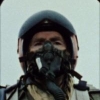
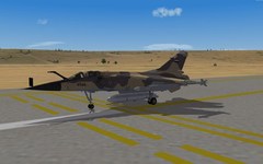
16 pointsmaking a aircraft and bring it in to the game is difficult enough but making a cockpit and try to get it work is a pain in the a..... F-4G_early cockpit , still a long way to go
-
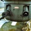
11 pointsJust another rocket test........................
-
5 pointsWorking on the Bleriot gunner today.
-
5 pointsSometimes, during a mission or when I die, it's nice to see what else is up in the sky and most recently it was this lovely Israeli Spitfire over Third Wire's best terrain.
-
4 pointsSaab-Hindustan J29H 'Gada' - No.1 Squadron, Indian Air Force
-
3 pointsThe new version of Kuril Islands terrain is 250m heighmap too. The planning map of the Kuril Islands terrain The planning map of Kuril Islands 250m As you see the new map includes mor of Hokkaido islands so that it has enough space to set more japanese airfields on it. If someone makes a new tileset for the current Kurilen Islands and wants to release it, so feel to do it. Would be a nice improvement.
-
3 pointsWell it's winter...was snowing last few days. Seriously. As always I needed to tweak something here and there... so few clicks and ini editing, and I have 3 seasons imported from Korea terrain. Well, it was more than clicks as I needed to re-create new tiles for some areas, made few changes and a few new tiles.
-
3 points
-
2 pointsGepard had a hi-res tileset for the Kuril Islands in the works, based on satellite imagery, very nice I can tell you. But it's not seasoned. You might want to join forces with him, but he is currently working on the Faroer terrain. I also made a 250m heightmap from scratch for the Kuril Islands terrain, as well as new planning maps and little tweaks here and there. But it's Gepard's terrain. First, I'd like to see his final product, then I might release a small (not standalone) enhancement package. Back to the thread, keep up the good work, JosefK! I am really liking your screenshots with those lightnings (not the F-35s, LOL!)
-
2 pointsIt looks like an estimate of "Two Weeks" would have been right on time for this project. To give you an update, I just have to finish work on the data files for the General Belgrano and give the edited ships an in game test and the Falklands 82 ships should all be ready. I would say within the next couple of days. The data files for the YAP Rising Sun ships will still be awhile yet.
-
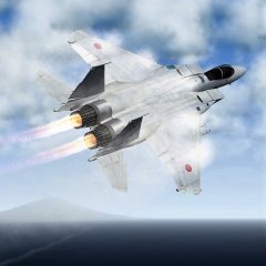
2 pointsCouldn't sleep last night so wrote an acute F-15J escort mission escorting two F-2As to attack. The final result: Su-27 Flankers going down Pair of Nanchuka patrol boats ambushed by ASM-2s.
-
2 pointsParan's first jet fighter
-
2 points@warthog64 I am in the possess of doing a full data file overhaul for the Falklands and the YAP Rising Sun ship data files. Falklands 82 ships should come first. Also that seems too weak for a US carrier due to US damage control.
-
1 pointWelcome old mate!! SFP2 ia a world better.
-
1 pointplease publish it now
-
1 point
-
1 pointIt is not you who explode; this is a collision with one of your wingman. Just change the formation in the FORMATION.INI file in the Flight folder (you may need to first extract it from MissionData.cat)
-
1 pointKorea, 1952...The bridge went down, but coming off target, the gunners were wide awake
-
1 pointFlaps.
-
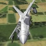
1 pointWhat a difference a week makes. Now there will be at least one JASDF F-35A mission... for more details, go to the mission pak development thread please: Requisite screenshots:
-
1 pointSome more Asian Scooters...this time from Indonesia! Actually this was the first mod I release here a looong time ago (with the help of dtmdragon - Dan ) - Now it's time for an update!
-
1 pointSupermarine Spitfire F.24 - No.303 (Polish) Squadron, RAF, 1947
-
1 point
-
1 pointLets make bouillabaisse. Its better than Fish n Chips.
-
1 pointor my pack from 2013
-
1 pointGreek Thunderchief over Cyprus, 1974
-
1 pointAnd one more screenie for this thread...couldn't resist posting this oddity. Von S


-
Popular Contributors
-
1

-
2

-
3
-
4

-
5

-
6

-
7
-
8
-
9

-
10
-

Important Information
By using this site, you agree to our Terms of Use, Privacy Policy, and We have placed cookies on your device to help make this website better. You can adjust your cookie settings, otherwise we'll assume you're okay to continue..